Moore Cove Falls Hike

This showery plunging waterfall is located in one of the most popular areas of the Pisgah National Forest, near the Davidson River in the "Land of Waterfalls". It's a delightful, beautiful walk thru fern-filled woods. And it's easy enough for families with small children to complete. This falls is highly recommended, and it could be combined with another nearby hike in the area if you want to add some more trail mileage to your day.
At A Glance
 1.4 mi round-trip
Difficulty Rating: 1.74 ![]()
Tread Condition: Few Obstacles ![]()
Climb: Climbs Gently ![]()
Climb Total: 160 ft
Configuration: Out-and-back
Starting Point: Parking area along US 276.
Trails Used: Moore Cove
Hike Start Location
Directions
From Asheville, take I-240 west, to I-26 east, to Exit 40, for the Asheville Airport and NC Hwy. 280. Turn right onto 280; follow this 4-lane highway for 16 miles toward Brevard. At the intersection with US Hwys. 276 and 64, turn right onto US 276 west. Proceed on US 276 for 6.6 miles past the Pisgan National Forest stone entrance marker. The parking area is on the right just before the highway crosses stone bridge over Looking Glass Creek.
Details
Hike Description

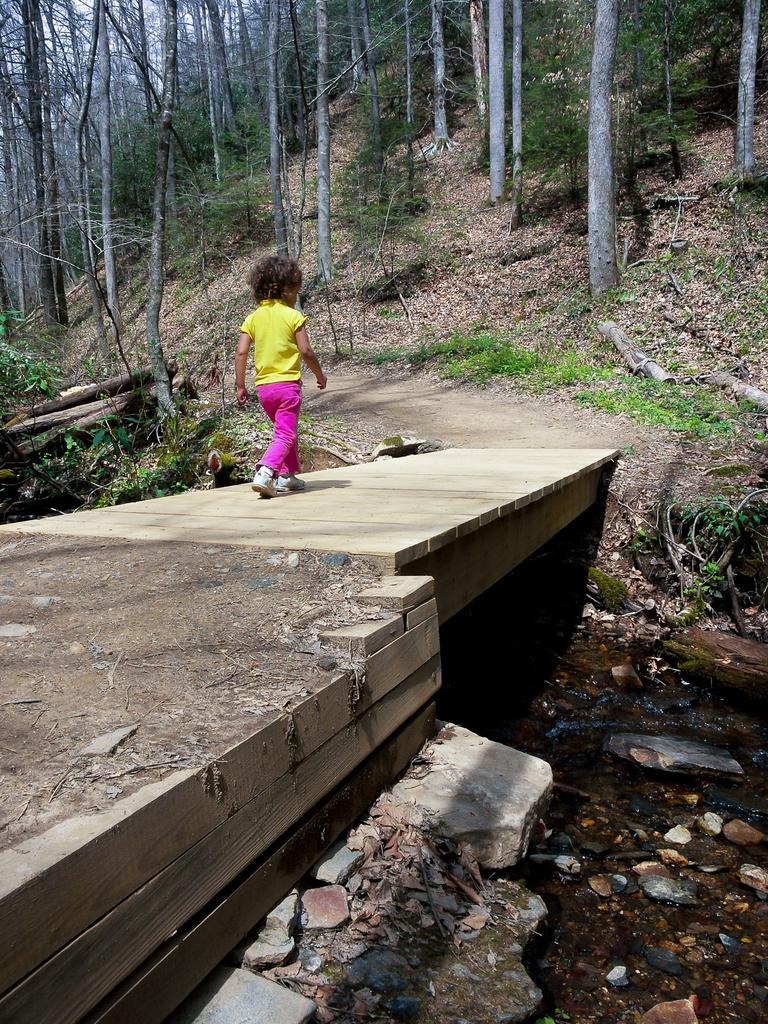
Begin the hike by crossing the sturdy wooden pedestrian bridge over Looking Glass Creek, built in June of 2007. It replaced another bridge that was just a few years old, which replaced the sketchy rock-hop or harrowing trip across the road bridge needed to get to the trail in years past. On the other side of the first bridge, the trail starts climbing - moderately at first, over some steps, before leveling out and even going downhill a bit.
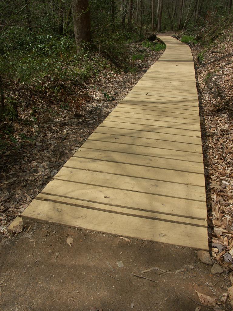
The entire Moore Cove Falls trail was re-graded in late 2011, eliminating almost all obstacles from the surface and providing sturdy wood structures for all creek crossings.
The wide, smooth trail travels through a lush, vibrant primarily cove hardwood forest the entire way to the falls. Trees such as tulip poplar, oak, and maple can be found, along with dark, lacy hemlocks (most of which have been killed, unfortunately, by the Hemlock Woolly Adelged - an exotic pest insect). An understory of rosebay rhododendron is found in places, and in other spots the steeply sloping forest floor is covered with a dense carpet of various ferns.

There are a couple of seeps located along this first section of the hike, which generally winds along the hill above Looking Glass Creek. You'll also find a couple of bridges and waterbars. At one point the trail skirts the base of a very large rock outcropping with two tall, straight birch trees growing up its face.
The trail then turns left into Moore Cove itself. After doing so, it's generally a steady, gradual climb up to the falls - but it does undulate up and down gently along the way as it winds around through the tall trees. All of the large hemlock trees are dead now, and will be shedding their limbs over the next few years before falling down completely. Since they tower over the trail, be careful on windy days! Some smaller hemlocks remain alive, for now.
You'll cross Moore Cove Creek on wooden bridges several times, and at several points along the way there are long log viaducts to keep the hiker dry through streamside wetland areas. The trail has been re-routed around all the rough sections, and some major dirt-moving was done to keep it a smooth path the whole way. Watch out for a few stray stobs and roots that remain, though.

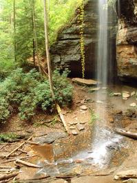
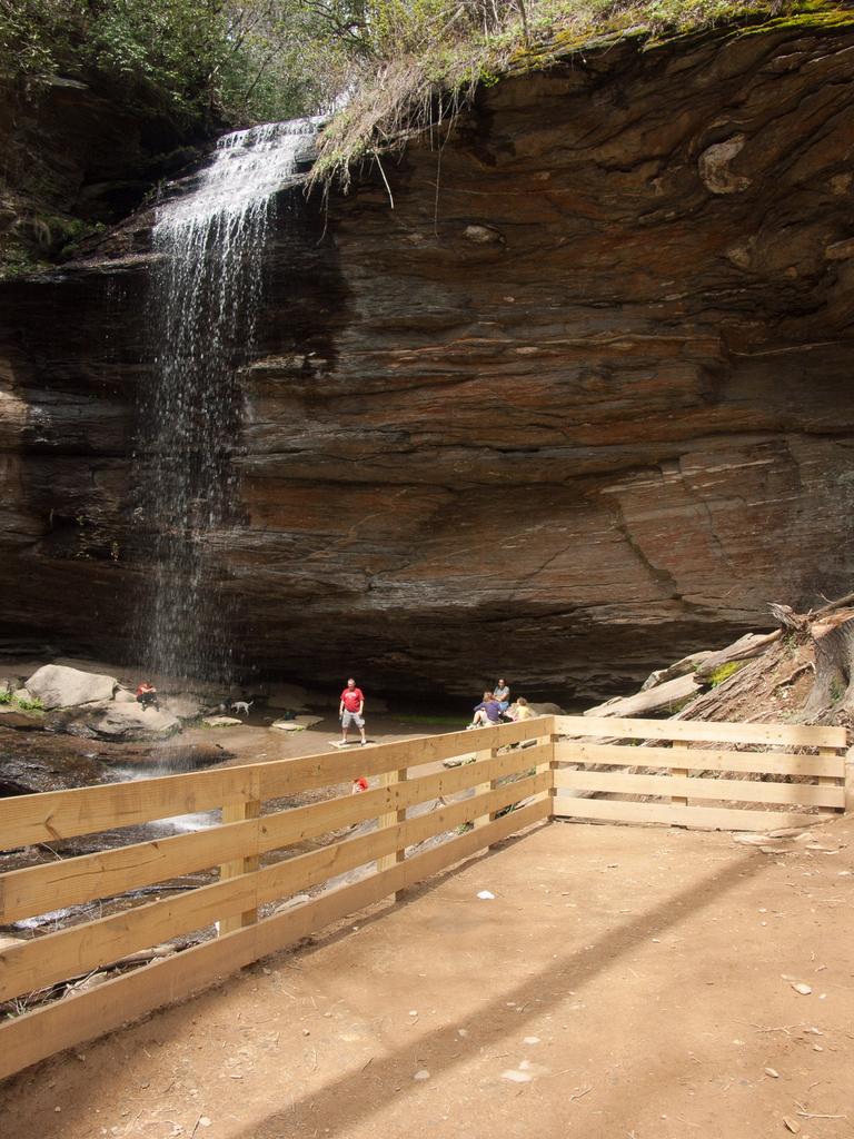
The trail ends at a large, new viewing area on the right side of the cove, with a great view of the falls. The big curved hemlocks that used to grow here have been cut down. You can still get behind the falls by going around the fence; although it's obvious that the Forest Service does not encourage this, on a hot day, the showery spray is inviting. {.clear}
Be careful on wet and slippery rocks, and do NOT attempt to reach the top of the falls. Several people have died here trying, and it is absolutely not the best view. And not only is it dangerous to you, it's destructive to the fragile plant communities that grow on the steep banks.
When you're finished enjoying the falls, return to your vehicle on the same path.
All Photos from This Hike


Map
Green highlight indicates the route to follow within the trail network for this hike.
Tip: Printing this map? You can pan and zoom the map as desired before printing to show the area you need.
Map Information
Download GPS Data
Click on a route, trail, or point on the map and select the GPS Data tab to download its data.
Data Formats
KML (Google Earth)
KML is the main file type used by Google Earth. If you have Google Earth installed, clicking the KML link should open the trail or point directly in Google Earth for viewing. This is the native file format used by Google Earth, but many other map applications can use and understand KML as well, so if you're not sure which one to download, KML is a good bet.
GPX
The GPX format stands for GPS Exchange - a free, open, XML format for exchanging GPS and map data. GPX is compatible with Google Earth, many other mapping programs, and most GPS devices (such as Garmin). Load the file directly into your GPS to help find your way on your next trip!
GeoJSON
GeoJSON is a newer, lightweight data exchange format which can be used to quickly share map data and may have a smaller size than KML or GPX. Many professional mapping and GIS applications support the GeoJSON format.
About the Map
Copyright
Base Layers
Base layers provided by OpenStreetMap, the US Geological Survey, the US Forest Service, and NC OneMap. Base layer images are subject to the respective copyright policies of their owners. Base layers may not be available at all times due to system maintenance or outages.
WNCOutdoors Base Layer
The WNCOutdoors Base layer is provided by WNCOutdoors.info. It is licensed by Creative Commons Attribution 3.0.
Trail and Marker Overlays
Trail layers and downloadable data are all original works created by WNCOutdoors with guidance from a variety of sources, including ensembles of our own GPS tracks, user contributed GPS tracks, official maps and GIS data from government agencies, and field observations. WNCOutdoors data is made freely available under the Open Database License - you are free to copy and use it for any purpose under the terms of that license (summary).
Tips
- Hover over a trail to see it highlighted. Helps to see start and end points for an individual trail.
- Scroll and zoom the map before printing, and that view will persist into the printed image.
- Click a trail for more details and to download it individually.
Feedback
Ratings
Average Rating: 2.3 (rated 96 times)
Rate It Now:

henry said: Can you stop and set up a tent on the trail to backpack?
John M said: Looking forward to seeing falls again. Its only been 40 years.
Eric said: https://www.youtube.com/watch?v=BANgmQdN1T0
jerry said: Parts of the trail follow along what appears to have been an old logging rail system of many decades ago. Look carefully, and you may be able to figure it out.
Alice said: Moore cove is always so beautiful. There is a small trail on the left side of the waterfall that is more like a climb then a hike but has a beautiful view from up high of the falls.
Stephanie Andersen said: It is absolutely magical to stand under the protruding rock, under and behind the falls, and watch the water spraying down into the pool below, backlit by sunlight.
Anthony Caputo said: great site
Dylan said: It was a nice short trail, good for little kids. The trail is just above looking glass falls, so the trail gets alot of attention. There was alot of trail work going on, so the trail was real muddy, I would advise on giving this trail some time to get cleared up, maybe a couple of months.
Matt said: The hike itself is short and sweet. It has multiple creek crossings, and a big trail-side rock. It's destination is truly beautiful: a completely accessible waterfall, a great cave for anyone who likes to boulder around, and smooth ground for barefoot play. There are large flat rocks that are perfect for laying on and soaking up the sun like a lizard. An ideal place for youngin's. The only qualm I have with this place is that if the weather is anywhere near decent, you can't count on solitude.