Flat Laurel Creek Trail

At A Glance


3.7 mi one-way
Difficulty Rating: 3.7 ![]()
Steepness: Climbs Gently ![]()
Tread Condition: Moderately Rough ![]()
Blaze Color: Orange
Trail Number: 346
Hikes That Use This Trail: Flat Laurel Creek
Description
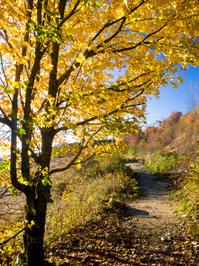
Follows an old railroad grade up from NC 215 to the end of FS 816, the Black Balsam parking area. It's a gentle climb on a wide trail; it's very rocky all the way. It's also a unique trail since it's entire length is above 5000 ft. elevation.
Starts with a crossing of Bubbling Springs Branch. You should be able to rock-hop this if the water is low; if it is extremely high it might not be a safe crossing. The trail then goes generally northeast into mixed high-elevation hardwoods. The forest transitions to mostly spruce/fir by the trail's upper end.
The trail passes over an old concrete bridge with Wildcat Falls streaming underneath it, then travels along the mountainside. There are some excellent views in more open areas. Prolific rhododendron, mountain laurel and blueberry shrubs line the trail. The trail slips into the Flat Laurel Creek valley and turns southeast; its eponymous stream has some nice cascades on the left side of the trail as the creek spills out of valley.
Above the cascades, the trail follows the creek for a ways before pulling away to the right. Flat Laurel Creek valley is indeed relatively flat. The trail passes nice campsites and through grassy, high-elevation meadows. Low forests and open meadows grow to the left with a dense spruce reforestation area to the right; several Fraser fir also line the trail. Although much maintenance has been done recently improving the surface, several stream crossings and wet areas round off the hike as it swings back to the north to meet the upper the parking area.
Intersecting Trails
This trail is located in the Black Balsam area. For a list of all the trails in that area, see the Black Balsam trails list page.
All Photos from the Trail


GPS Map
Map Information
Download GPS Data
Click on a route, trail, or point on the map and select the GPS Data tab to download its data.
Data Formats
KML (Google Earth)
KML is the main file type used by Google Earth. If you have Google Earth installed, clicking the KML link should open the trail or point directly in Google Earth for viewing. This is the native file format used by Google Earth, but many other map applications can use and understand KML as well, so if you're not sure which one to download, KML is a good bet.
GPX
The GPX format stands for GPS Exchange - a free, open, XML format for exchanging GPS and map data. GPX is compatible with Google Earth, many other mapping programs, and most GPS devices (such as Garmin). Load the file directly into your GPS to help find your way on your next trip!
GeoJSON
GeoJSON is a newer, lightweight data exchange format which can be used to quickly share map data and may have a smaller size than KML or GPX. Many professional mapping and GIS applications support the GeoJSON format.
About the Map
Copyright
Base Layers
Base layers provided by OpenStreetMap, the US Geological Survey, the US Forest Service, and NC OneMap. Base layer images are subject to the respective copyright policies of their owners. Base layers may not be available at all times due to system maintenance or outages.
WNCOutdoors Base Layer
The WNCOutdoors Base layer is provided by WNCOutdoors.info. It is licensed by Creative Commons Attribution 3.0.
Trail and Marker Overlays
Trail layers and downloadable data are all original works created by WNCOutdoors with guidance from a variety of sources, including ensembles of our own GPS tracks, user contributed GPS tracks, official maps and GIS data from government agencies, and field observations. WNCOutdoors data is made freely available under the Open Database License - you are free to copy and use it for any purpose under the terms of that license (summary).
Tips
- Hover over a trail to see it highlighted. Helps to see start and end points for an individual trail.
- Scroll and zoom the map before printing, and that view will persist into the printed image.
- Click a trail for more details and to download it individually.
Trail Segments
Trails are often made up of several connecting paths which may have different characteristics, allowed uses, and seasons. This trail is divided into multiple segments as follows:
Flat Laurel Creek - NC 215 to Sam Knob Tr.
- Allowed Uses: Hiking, Mountain Biking
- Length: 2.32 mi
Flat Laurel Creek - Sam Knob Tr. to Little Sam Tr.
- Allowed Uses: Hiking, Mountain Biking
- Length: 0.38 mi
Flat Laurel Creek - Little Sam Tr. to Ivestor Gap Parking
- Allowed Uses: Hiking, Mountain Biking
- Length: 1.07 mi
Total Calculated Length: 3.76 mi
This value is derived from our underlying map data, and it may not match officially published information.
Feedback
Ratings
Average Rating: 3.7 (rated 13 times)
Rate It Now:

Warren said: September 2, 2021. Hiked the upper portion of Flat Laurel Creek Trail after doing Sam Knob from the parking area. This trail is rated easy, maybe because the grade is very gradual. The trail condition was wet the whole way up, very rocky (small, medium and larger); narrow U-shaped tread much of the way. I did this entire trail on mountain bike about 5 years ago, from 215 parking to the top, but I would not be able to bike this now; it seems the erosion has made it too difficult for me; there are many 12”-18” drops that would stop me going up. Coming down on bike would be a challenge too. Many bushes very close to the trail, at spots, leaves you claustrophobic.
hulia kelly said: excellent information here!