Bridges Camp Gap Trail

At A Glance


1 mi one-way
Difficulty Rating: 1 ![]()
Steepness: Climbs Moderately ![]()
Tread Condition: Moderately Rough ![]()
Trail Number: 607
Description
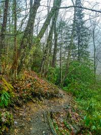
Starting on the Parkway in a mixed hardwood/spruce forest, the trail descends over a somewhat rocky path on an easy grade. You'll hear the river in the valley below. The trail passes through one switchback to the left and then into a wetter forest near the river with rhododendron and galax. The trail reaches another switchback at a campsite, and a very scenic stretch of the river.
Now heading downstream, the trail follows an old railroad grade where it passes relics from the age of widespread logging in the valley. You might see metal parts from old trains and railroad ties still embedded in the grade. The climb is very gentle and there are only a few spots with any notable obstacles. The river is below the trail and you'll get some wintertime views of several nice pools and cascades. The forest is lush and green, with lots of mossy rocks, and a few neat outcroppings.
The trail crosses into the Shining Rock Wilderness shortly before the junction with the Big East Fork (straight ahead) and Greasy Cove (left, across the river) trails. There is another nice campsite at the junction, and several small cascades worth exploring on the streams.
The Big East Fork trail continues downstream for 3.6 mi to the trailhead on US 276, while the Greasy Cove trail climbs 3.2 mi up to Ivestor Gap, making a long loop hike possible by combining this with Graveyard Ridge and the Mountains to Sea trails.
Intersecting Trails
This trail is located in the Blue Ridge Parkway Section 5 area. For a list of all the trails in that area, see the Blue Ridge Parkway Section 5 trails list page.
This trail also crosses into these trailhead areas:
All Photos from the Trail


GPS Map
Map Information
Download GPS Data
Click on a route, trail, or point on the map and select the GPS Data tab to download its data.
Data Formats
KML (Google Earth)
KML is the main file type used by Google Earth. If you have Google Earth installed, clicking the KML link should open the trail or point directly in Google Earth for viewing. This is the native file format used by Google Earth, but many other map applications can use and understand KML as well, so if you're not sure which one to download, KML is a good bet.
GPX
The GPX format stands for GPS Exchange - a free, open, XML format for exchanging GPS and map data. GPX is compatible with Google Earth, many other mapping programs, and most GPS devices (such as Garmin). Load the file directly into your GPS to help find your way on your next trip!
GeoJSON
GeoJSON is a newer, lightweight data exchange format which can be used to quickly share map data and may have a smaller size than KML or GPX. Many professional mapping and GIS applications support the GeoJSON format.
About the Map
Copyright
Base Layers
Base layers provided by OpenStreetMap, the US Geological Survey, the US Forest Service, and NC OneMap. Base layer images are subject to the respective copyright policies of their owners. Base layers may not be available at all times due to system maintenance or outages.
WNCOutdoors Base Layer
The WNCOutdoors Base layer is provided by WNCOutdoors.info. It is licensed by Creative Commons Attribution 3.0.
Trail and Marker Overlays
Trail layers and downloadable data are all original works created by WNCOutdoors with guidance from a variety of sources, including ensembles of our own GPS tracks, user contributed GPS tracks, official maps and GIS data from government agencies, and field observations. WNCOutdoors data is made freely available under the Open Database License - you are free to copy and use it for any purpose under the terms of that license (summary).
Tips
- Hover over a trail to see it highlighted. Helps to see start and end points for an individual trail.
- Scroll and zoom the map before printing, and that view will persist into the printed image.
- Click a trail for more details and to download it individually.
Feedback
Ratings
Average Rating: (rated 0 times)
Rate It Now:

L Johnson said: This is a beautiful trail with a drop dead gorgeous river. Book descriptions of this trail were difficult to follow and we never made it to the second campsite before we had to turn around due to rain. Forks in the trail are poorly marked so use the GPS attached to this site for reference. Enjoy!