Cat Gap Bypass Trail

At A Glance


0.4 mi one-way
Difficulty Rating: 0.62 ![]()
Steepness: Level ![]()
Tread Condition: Few Obstacles ![]()
Lowest Elevation: 3000 ft
Highest Elevation: 3120 ft
Climb Total: 120 ft
Blaze Color: Yellow
Trail Number: 120A
Hikes That Use This Trail: John Rock Loop
Description
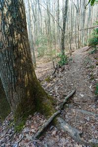
Level or gradually climbing trail cuts through the upper end of the cove that gives rise to John Rock Branch. The trail swings into smaller head-coves & around low ridges. Passes mainly through a mixed hardwood forest with some hemlocks and pines; has a few rhododendron tunnels. Makes a pleasant walk. Cuts off the climb up to Cat Gap on the Cat Gap Loop trail; makes a nice alternative for less effort.
Directions
This trail connects to the Cat Gap Loop trail at both ends. You'll have to hike Cat Gap Loop to reach it.
Intersecting Trails
This trail is located in the Davidson River area. For a list of all the trails in that area, see the Davidson River trails list page.
All Photos from the Trail


GPS Map
Map Information
Download GPS Data
Click on a route, trail, or point on the map and select the GPS Data tab to download its data.
Data Formats
KML (Google Earth)
KML is the main file type used by Google Earth. If you have Google Earth installed, clicking the KML link should open the trail or point directly in Google Earth for viewing. This is the native file format used by Google Earth, but many other map applications can use and understand KML as well, so if you're not sure which one to download, KML is a good bet.
GPX
The GPX format stands for GPS Exchange - a free, open, XML format for exchanging GPS and map data. GPX is compatible with Google Earth, many other mapping programs, and most GPS devices (such as Garmin). Load the file directly into your GPS to help find your way on your next trip!
GeoJSON
GeoJSON is a newer, lightweight data exchange format which can be used to quickly share map data and may have a smaller size than KML or GPX. Many professional mapping and GIS applications support the GeoJSON format.
About the Map
Copyright
Base Layers
Base layers provided by OpenStreetMap, the US Geological Survey, the US Forest Service, and NC OneMap. Base layer images are subject to the respective copyright policies of their owners. Base layers may not be available at all times due to system maintenance or outages.
WNCOutdoors Base Layer
The WNCOutdoors Base layer is provided by WNCOutdoors.info. It is licensed by Creative Commons Attribution 3.0.
Trail and Marker Overlays
Trail layers and downloadable data are all original works created by WNCOutdoors with guidance from a variety of sources, including ensembles of our own GPS tracks, user contributed GPS tracks, official maps and GIS data from government agencies, and field observations. WNCOutdoors data is made freely available under the Open Database License - you are free to copy and use it for any purpose under the terms of that license (summary).
Tips
- Hover over a trail to see it highlighted. Helps to see start and end points for an individual trail.
- Scroll and zoom the map before printing, and that view will persist into the printed image.
- Click a trail for more details and to download it individually.
Feedback
Ratings
Average Rating: 5.0 (rated 1 times)
Rate It Now:

Robert Foster said: Great trail! A few great climbs and then it's downhill and amazing sites. Great for dog hike as well. Our beagle loved it. We saw everything from small falls to rhododendron tunnels and so on. A lot of nice places to camp as well.