Florence Preserve Blue Trail

At A Glance


1.8 mi one-way
Difficulty Rating: 1.8 ![]()
Steepness: Climbs Moderately ![]()
Tread Condition: Moderately Rough ![]()
Blaze Color: Blue
Description
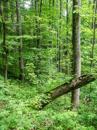
As Florence Preserve's longest trail, this one has a variety of character. From Kelly Mountain Road up to the Yellow trailhead connector, this is a narrow, slope-side trail with a couple of creek crossings on log bridges. Some neat trees grow here, and there is a relatively healthy hemlock stand beside some tiny cascades on the creek. From the yellow connector, the trail widens onto an old stream side road bed, with some more healthy and unhealthy hemlocks. From the next Yellow trail on the left up to the White trail, it's more twisty and narrow, and passes through an area devastated by Hemlock Wooly Adelgid. There are lots of dead rhododendron, as well. (Avoid this section until the hemlocks stop falling). North of the White trail intersection it levels out, pulls away from the creek, and widens again. Here it passes through a more open forest, before swinging west back into the creek drainage through another rhododendron grove. Beyond the creek crossing - on a wide, road-sized bridge - the trail passes through a small open area before winding up to Little Pisgah road.
Intersecting Trails
This trail is located in the Florence Nature Preserve area. For a list of all the trails in that area, see the Florence Nature Preserve trails list page.
This trail also crosses into these trailhead areas:
All Photos from the Trail


GPS Map
Map Information
Download GPS Data
Click on a route, trail, or point on the map and select the GPS Data tab to download its data.
Data Formats
KML (Google Earth)
KML is the main file type used by Google Earth. If you have Google Earth installed, clicking the KML link should open the trail or point directly in Google Earth for viewing. This is the native file format used by Google Earth, but many other map applications can use and understand KML as well, so if you're not sure which one to download, KML is a good bet.
GPX
The GPX format stands for GPS Exchange - a free, open, XML format for exchanging GPS and map data. GPX is compatible with Google Earth, many other mapping programs, and most GPS devices (such as Garmin). Load the file directly into your GPS to help find your way on your next trip!
GeoJSON
GeoJSON is a newer, lightweight data exchange format which can be used to quickly share map data and may have a smaller size than KML or GPX. Many professional mapping and GIS applications support the GeoJSON format.
About the Map
Copyright
Base Layers
Base layers provided by OpenStreetMap, the US Geological Survey, the US Forest Service, and NC OneMap. Base layer images are subject to the respective copyright policies of their owners. Base layers may not be available at all times due to system maintenance or outages.
WNCOutdoors Base Layer
The WNCOutdoors Base layer is provided by WNCOutdoors.info. It is licensed by Creative Commons Attribution 3.0.
Trail and Marker Overlays
Trail layers and downloadable data are all original works created by WNCOutdoors with guidance from a variety of sources, including ensembles of our own GPS tracks, user contributed GPS tracks, official maps and GIS data from government agencies, and field observations. WNCOutdoors data is made freely available under the Open Database License - you are free to copy and use it for any purpose under the terms of that license (summary).
Tips
- Hover over a trail to see it highlighted. Helps to see start and end points for an individual trail.
- Scroll and zoom the map before printing, and that view will persist into the printed image.
- Click a trail for more details and to download it individually.
Trail Segments
Trails are often made up of several connecting paths which may have different characteristics, allowed uses, and seasons. This trail is divided into multiple segments as follows:
Kelly Hill Rd. to Yellow Connector Tr.
- Allowed Uses: Hiking
- Length: 0.33 mi
Yellow Connector Tr. to Yellow Tr.
- Allowed Uses: Hiking
- Length: 0.31 mi
Yellow Tr. to White Tr.
- Allowed Uses: Hiking
- Length: 0.31 mi
White Tr. to Orange Tr.
- Allowed Uses: Hiking
- Length: 0.13 mi
Orange Tr. to Red Tr. (Meadow)
- Allowed Uses: Hiking
- Length: 0.13 mi
Red Tr. (Meadow) to Little Pisgah Rd.
- Allowed Uses: Hiking
- Length: 0.28 mi
Total Calculated Length: 1.49 mi
This value is derived from our underlying map data, and it may not match officially published information.
Feedback
Ratings
Average Rating: (rated 0 times)
Rate It Now:

No comments yet.