Summit Trail

At A Glance


0.1 mi one-way
Difficulty Rating: 0.27 ![]()
Steepness: Climbs Moderately ![]()
Tread Condition: Paved ![]()
Lowest Elevation: 6580 ft
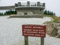
Highest Elevation: 6684 ft
Climb Total: 104 ft
Blaze Color: None
Hikes That Use This Trail: Old Mitchell, Mount Mitchell
Description
This easy leg stretcher leads from the summit parking area to the circular observation platform at the summit itself.
This is a paved path through a Fraser fir forest that was wiped out in the 1980's. All the mature firs died, but new ones sprouted everywhere to take their place. When I hiked this as a kind in the 90's, it looked like a Christmas tree farm with dead trunks still standing. As of 2020, the firs are tall enough to create a canopy and arch over the trail, creating a forest once again (albeit with some open areas, making for beautiful views that increase as you go up).
Halfway up you'll pass the old museum building, now used as a classroom by park naturalists. The Balsam Nature trail joins just past the building on the left. Use that on the return for a nice, easy loop that includes the summit.
The platform provides spectacular views from the highest point east of the Mississippi river. The summit of Mt. Mitchell is now accessible to everyone.
Intersecting Trails
This trail is located in the Mount Mitchell State Park area. For a list of all the trails in that area, see the Mount Mitchell State Park trails list page.
All Photos from the Trail


GPS Map
Map Information
Download GPS Data
Click on a route, trail, or point on the map and select the GPS Data tab to download its data.
Data Formats
KML (Google Earth)
KML is the main file type used by Google Earth. If you have Google Earth installed, clicking the KML link should open the trail or point directly in Google Earth for viewing. This is the native file format used by Google Earth, but many other map applications can use and understand KML as well, so if you're not sure which one to download, KML is a good bet.
GPX
The GPX format stands for GPS Exchange - a free, open, XML format for exchanging GPS and map data. GPX is compatible with Google Earth, many other mapping programs, and most GPS devices (such as Garmin). Load the file directly into your GPS to help find your way on your next trip!
GeoJSON
GeoJSON is a newer, lightweight data exchange format which can be used to quickly share map data and may have a smaller size than KML or GPX. Many professional mapping and GIS applications support the GeoJSON format.
About the Map
Copyright
Base Layers
Base layers provided by OpenStreetMap, the US Geological Survey, the US Forest Service, and NC OneMap. Base layer images are subject to the respective copyright policies of their owners. Base layers may not be available at all times due to system maintenance or outages.
WNCOutdoors Base Layer
The WNCOutdoors Base layer is provided by WNCOutdoors.info. It is licensed by Creative Commons Attribution 3.0.
Trail and Marker Overlays
Trail layers and downloadable data are all original works created by WNCOutdoors with guidance from a variety of sources, including ensembles of our own GPS tracks, user contributed GPS tracks, official maps and GIS data from government agencies, and field observations. WNCOutdoors data is made freely available under the Open Database License - you are free to copy and use it for any purpose under the terms of that license (summary).
Tips
- Hover over a trail to see it highlighted. Helps to see start and end points for an individual trail.
- Scroll and zoom the map before printing, and that view will persist into the printed image.
- Click a trail for more details and to download it individually.
Trail Segments
Trails are often made up of several connecting paths which may have different characteristics, allowed uses, and seasons. This trail is divided into multiple segments as follows:
Mount Mitchell Summit - Parking to Old Mitchell
- Allowed Uses: Hiking, Accessible
- Length: 263 ft
Mount Mitchell Summit - To Summit
- Allowed Uses: Hiking, Accessible
- Length: 505 ft
Mount Mitchell Summit - Mountains to Sea - to Balsam Nature
- Allowed Uses: Hiking, Accessible
- Length: 248 ft
Total Calculated Length: 0.19 mi
This value is derived from our underlying map data, and it may not match officially published information.
Feedback
Ratings
Average Rating: (rated 0 times)
Rate It Now:

No comments yet.