Little Green Trail

At A Glance


0.96 mi one-way
Difficulty Rating: 1.71 ![]()
Steepness: Level ![]()
Tread Condition: Few Obstacles ![]()
Lowest Elevation: 3660 ft
Highest Elevation: 4075 ft
Climb Total: 415 ft
Blaze Color: Green
Trail Number: 485
Description

This trail first takes you to Schoolhouse Falls (if starting on the northeast end at the Panthertown Valley trail where it crosses Greenland Creek, near the Cold Mountain entrance to the valley). It starts as a level course along the creek, where there are some bridge structures to carry you over some muddy seeps. It's a white pine forest with a few scattered Eastern Hemlock (still alive as of late 2018), and an understory thick with rhododendron and doghobble. You'll hear the falls to the left down a short set of steps. The trail dumps you out on the rocky bar at the far end of the plunge pool, river-right. This is where most people stop.
At the top of the steps, the Little Green trail continues west up Little Green Mountain (left if coming from the falls; right if coming from the Panthertown Valley trail junction). It climbs somewhat steeply through a mixed hardwood forest over steps of logs and roots. Various clubmosses line the trail in places, and some openings in the otherwise dense forest give it a neat feeling. As you approach the top of Little Green Mountain, the soil gets exceedingly thin and the trail pops out onto bare rock in places. You can study the exposed roots systems of the red maple, oak, and sourwood trees that have eroded near the trail. Clumps of huckleberry and blueberry appear near the summit, and they produce prolifically early in the season (late June on my last visit).
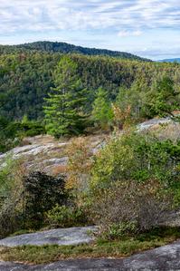
You'll arrive at the top of Little Green Mountain, where the trail enters a short coniferous forest of mostly white pine before emerging on the west-facing rocks with some spectacular views toward Granny Burrell Falls, Salt Rock and the west end of the valley. The trail then swings south, winds along the edge of the rock face in a descending fashion with views to the west the whole way. The trail re-enters the forest in a rhododendron and laurel thicket. It may be a bit difficult to follow the path at this point, but on my last trip there were ribbons marking the spots that lacked blazes.
After re-entering the forest, the trail crosses a low summit where it may also become indistinct. A few blazes would help here. It descends the north end of Little Green Mountain on a long series of steps before leveling out some, joining with an old road, swinging right, and joining with the Mac's Gap trail, making some good loop options available in both directions.
Intersecting Trails
This trail is located in the Panthertown Valley area. For a list of all the trails in that area, see the Panthertown Valley trails list page.
All Photos from the Trail


GPS Map
Map Information
Download GPS Data
Click on a route, trail, or point on the map and select the GPS Data tab to download its data.
Data Formats
KML (Google Earth)
KML is the main file type used by Google Earth. If you have Google Earth installed, clicking the KML link should open the trail or point directly in Google Earth for viewing. This is the native file format used by Google Earth, but many other map applications can use and understand KML as well, so if you're not sure which one to download, KML is a good bet.
GPX
The GPX format stands for GPS Exchange - a free, open, XML format for exchanging GPS and map data. GPX is compatible with Google Earth, many other mapping programs, and most GPS devices (such as Garmin). Load the file directly into your GPS to help find your way on your next trip!
GeoJSON
GeoJSON is a newer, lightweight data exchange format which can be used to quickly share map data and may have a smaller size than KML or GPX. Many professional mapping and GIS applications support the GeoJSON format.
About the Map
Copyright
Base Layers
Base layers provided by OpenStreetMap, the US Geological Survey, the US Forest Service, and NC OneMap. Base layer images are subject to the respective copyright policies of their owners. Base layers may not be available at all times due to system maintenance or outages.
WNCOutdoors Base Layer
The WNCOutdoors Base layer is provided by WNCOutdoors.info. It is licensed by Creative Commons Attribution 3.0.
Trail and Marker Overlays
Trail layers and downloadable data are all original works created by WNCOutdoors with guidance from a variety of sources, including ensembles of our own GPS tracks, user contributed GPS tracks, official maps and GIS data from government agencies, and field observations. WNCOutdoors data is made freely available under the Open Database License - you are free to copy and use it for any purpose under the terms of that license (summary).
Tips
- Hover over a trail to see it highlighted. Helps to see start and end points for an individual trail.
- Scroll and zoom the map before printing, and that view will persist into the printed image.
- Click a trail for more details and to download it individually.
Trail Segments
Trails are often made up of several connecting paths which may have different characteristics, allowed uses, and seasons. This trail is divided into multiple segments as follows:
Little Green - Schoolhouse Falls to Mac's Gap
- Allowed Uses: Hiking
- Length: 0.86 mi
Little Green - Panthertown Valley Tr. to Schoolhouse Falls
- Allowed Uses: Hiking
- Length: 0.16 mi
Total Calculated Length: 1.01 mi
This value is derived from our underlying map data, and it may not match officially published information.
Feedback
Ratings
Average Rating: 4.0 (rated 1 times)
Rate It Now:

[Site Admin] Jordan M. said: Andrea - good thinking to turn around. Coming darkness and a slight trip-up in locating the trail can be all it takes to turn a fun hike into a misadventure. I agree that this one needs some additional signage, but I was hoping it'd been improved since the last time I hiked it a couple of years ago. Guess not :)
Andrea Clark said: I got to the top with my husband and started to follow the trail back to finish up the loop and we got a little lost and couldn't find the trail... The sun started to go down and we only had a small day pack with us and we started to panic a little bit... We had to turn around and go back the way we came because there was no way we were going to be able to find the trail in the dark if we continued trying to follow the trail around.
James Plank said: The schoolhouse falls and the view from the top are excellent and highly recommended. Once you're on the rock face, finding the trail is difficult, and I ended up bushwhacking a bit to find the trail before it spilled back toward Mac's Gap. The couple I met on the rock face were coming from Mac's Gap and had an equally hard time finding the trail coming the opposite directions. The arrows on the rocks are helpful, but finding the trail once you leave the rock face is a challenge, and could use a sign or too....