North Harper Creek Falls Trail

At A Glance


1.3 mi one-way
Difficulty Rating: 1.3 ![]()
Steepness: Climbs Steeply ![]()
Tread Condition: Moderately Rough ![]()
Blaze Color: Yellow
Trail Number: 239
Description
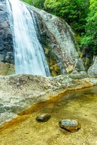
75% of this trail is in great shape; travels along an old roadbed through beautiful woods with few obstacles. Judging by the size of the trees growing on the roadbed, it's been here a while. The last little bit turns into a true foot path and is a bit rougher. Ends at the intersection with the blue-blazed North Harper Creek trail; to get the rest of the way to the falls, turn left and go down a steep portion of that path. The steep part comes out at the top of a smaller sliding cascade called Chestnut Cove Branch Falls. Turn right onto an un-named but obvious path, which comes to a creek crossing. Go upstream on either side of the creek about 100' to the falls.
Intersecting Trails
This trail is located in the Wilson Creek Area area. For a list of all the trails in that area, see the Wilson Creek Area trails list page.
All Photos from the Trail


GPS Map
Map Information
Download GPS Data
Click on a route, trail, or point on the map and select the GPS Data tab to download its data.
Data Formats
KML (Google Earth)
KML is the main file type used by Google Earth. If you have Google Earth installed, clicking the KML link should open the trail or point directly in Google Earth for viewing. This is the native file format used by Google Earth, but many other map applications can use and understand KML as well, so if you're not sure which one to download, KML is a good bet.
GPX
The GPX format stands for GPS Exchange - a free, open, XML format for exchanging GPS and map data. GPX is compatible with Google Earth, many other mapping programs, and most GPS devices (such as Garmin). Load the file directly into your GPS to help find your way on your next trip!
GeoJSON
GeoJSON is a newer, lightweight data exchange format which can be used to quickly share map data and may have a smaller size than KML or GPX. Many professional mapping and GIS applications support the GeoJSON format.
About the Map
Copyright
Base Layers
Base layers provided by OpenStreetMap, the US Geological Survey, the US Forest Service, and NC OneMap. Base layer images are subject to the respective copyright policies of their owners. Base layers may not be available at all times due to system maintenance or outages.
WNCOutdoors Base Layer
The WNCOutdoors Base layer is provided by WNCOutdoors.info. It is licensed by Creative Commons Attribution 3.0.
Trail and Marker Overlays
Trail layers and downloadable data are all original works created by WNCOutdoors with guidance from a variety of sources, including ensembles of our own GPS tracks, user contributed GPS tracks, official maps and GIS data from government agencies, and field observations. WNCOutdoors data is made freely available under the Open Database License - you are free to copy and use it for any purpose under the terms of that license (summary).
Tips
- Hover over a trail to see it highlighted. Helps to see start and end points for an individual trail.
- Scroll and zoom the map before printing, and that view will persist into the printed image.
- Click a trail for more details and to download it individually.
Feedback
Ratings
Average Rating: 5.0 (rated 2 times)
Rate It Now:

James E said: To emphasize what Steve said, there is a new leg of the trail cut in since 2015. From North Harper Creek Falls Trail, at the intersection with the blue-blazed North Harper Creek trail, you can no longer turn left, but should follow the blue blazes straight to cross the creek on the open flat rocks. Continue on the new portion of the trail for a shorter/easier route to the falls. Looking downstream, the old route descended on the left side, and the new route descends to the right of the falls.
Steve Houtchings said: On north Harper creek trail coming from TH on kawana rd, campsite on right by the top of sliding portion of n Harper falls,cross creek here. Trail is easy to miss but is shorter route that comes out at base of falls. Chestnut creek falls is about .3 miles and bard falls is about 2.5 further downstream. Hiking Harper creek to raider camp trail looping back around and coming down Harper trail starting today happy trails