Devil's Courthouse Hike

This hike takes you to the summit of Devil's Courthouse, a high-elevation rocky summit with a fantastic cliff-top overlook. But this isn't the usual route used by most casual tourists, which is a paved trail starting at a Parkway overlook. Rather, you'll hike a beautiful section of the Mountains to Sea Trail through high-elevation woods, meadows, and spruce-fir forests. The extra hiking will make reaching the summit feel like more of an accomplishment while showing you much more of what the beautiful high country area has to offer.
At A Glance
 4.3 mi round-trip
Difficulty Rating: 6.05 ![]()
Tread Condition: Moderately Rough ![]()
Climb: Climbs Moderately ![]()
Lowest Elevation: 5120 ft
Highest Elevation: 5720 ft
Climb Total: 600 ft
Configuration: Out-and-back
Starting Point: MST crossing of NC 215
Trails Used: Devil's Courthouse, Mountains to Sea Section 2, Devil's Courthouse Connector
Hike Start Location
Directions
From the junction of the Blue Ridge Parkway and NC Hwy. 215 south of Mount Pisgah, NC, take NC 215 north (toward Canton) just under 1/2 mile. A large parking pull-off is on the left just before the Mountains to Sea Trail crossing of NC 215. Park there.
If you're coming from the Canton/Waynesville area, take NC 215 south. Reset your odometer at the bridge just past the Sunburst campground & picnic area. The parking area is 7.9 miles ahead, on the right.
Details
Hike Description

The hike begins on the Mountains to Sea Trail less than 0.1 mi downhill from the main parking area along NC 215. There is another, smaller parking spot at the crossing, just before a bridge over Bubbling Spring Branch. Look for the Mountains to Sea Trail sign post and a set of steps leading uphill on the right (north).
After climbing the steps, the trail enters the forest. The first feet are rough and eroded, but the trail tread condition quickly improves. Although some eroded spots show up over the length of this hike, it is for the most part in good condition - especially relative to some of the other trails in this part of the Pisgah high country.
The trail passes through shrubby forest of mixed hardwoods and high-elevation conferous trees, a forest type you'll remain in for the entirety of the hike. In addition to the near-ubiquitous red maple and red and white oak, you'll find sweet birch, stands of American beech, a few eastern hemlocks, and areas where the trail passes in and out of dense stands of pure red spruce. In these areas, the forest floor is devoid of the usual understory shrubs, and instead carpeted by a blanket of dense spruce needles. It's a neat departure from the usual scenery in these parts. Though the spruces are more numerous, a fair number of Fraser fir grow alongside the trail - some of which are getting fairly large.
The trail climbs gently for about 0.2 mi, and then commences a bit steeper section for about the next 0.3 mi as it approaches a small unnamed tributary of Bubbling Spring Branch. The trail climbs alongside the branch where there are some shallow slides just short of what I'd call "waterfalls".
It comes to a point where the trail appears to cross the branch in between two of the small slides. However, this isn't the actual trail crossing. Instead, keep right and continue uphill beside the creek - it's blazed. The trail swings left in about 100 ft. back toward the creek below a big upturned red spruce rootball and crosses the creek on a footbridge in a stand of spruce.
Across the creek, the trail continues a moderate climb through some interesting terrain and a forest filled with American beech. There are a couple of switchbacks, one of which is below a big, neat rock outcropping. The trail then comes out on a relatively flat ridgetop area and loops around to the north of a low summit. This is a pleasant, easy, level stretch of trail.

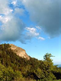
Some nice views open up off to the left of the areas around Mount Hardy, the Bubbling Spring Branch valley, and Devil's Courthouse, which appears to be in the wrong direction to reach on this hike (but which the trail approaches up ahead nevertheless).
The trail loops around the north side of the ridge, then curves back south through some beautiful fern-filled sections of birch forests. It reaches the edge of a small escarpment of sorts, then curves left to avoid dropping off the side of it. It passes through a small, grassy clearing, and then into section of dense red spruce. This patch of spruce appears to be one of the reforestation plantings that were made here after the fires of the early 1900's.

Leaving the patch of spruces behind, the trail resumes a gradual climb and then crosses a couple of tiny seeps or spring branches - the very top headwaters of the branch you crossed earlier. These are easily rock-hopped and crossed on the provided wooden bridges.

You might start to hear traffic on the Blue Ridge Parkway again down below. Just past the second tributary, look for the junction with the Devil's Courthouse Connector trail on the right and take that trail.
This short trail connects the Mountains to Sea Trail you've been on to the main Devil's Courthouse trail up ahead. It crosses over the Devil's Courthouse tunnel on the Blue Ridge Parkway along the way, but you won't notice it except perhaps that you now hear the noise of vehicles behind instead of in front of you. It dips into a low point and climbs again slightly before the next junction, which is at the end of the paved portion of the Blue Ridge Parkway's Devil's Courthouse trail.
The parking area at the overlook is less than 1/2 mile to the right, downhill (and that's how most people come to climb Devil's Courthouse). Turn left here onto a very rocky and eroded path.
This is a very heavily used portion of trail, and it's steeper than what you've hiked thus far, but fortunately it's short. It comes out into the main overlook on Devil's Courthouse with spectacular 180 degree views from south, to west, to north.
Plaques mounted on the overlook walls label the mountains you'll see with an interesting alignment-of-knobs setup. Stay within the boundaries of the overlook - due to peregrine falcon nesting sites present on the cliffs, it is illegal to leave the trail or overlook on Devil' Courthouse.

When you're finished enjoying the view, return to the connector trail on the right to re-enter the relative solitude of the National Forest, and take a left on the Mountains to Sea Trail to return to your vehicle on an almost all-downhill path.
All Photos from This Hike


Map
Green highlight indicates the route to follow within the trail network for this hike.
Tip: Printing this map? You can pan and zoom the map as desired before printing to show the area you need.
Map Information
Download GPS Data
Click on a route, trail, or point on the map and select the GPS Data tab to download its data.
Data Formats
KML (Google Earth)
KML is the main file type used by Google Earth. If you have Google Earth installed, clicking the KML link should open the trail or point directly in Google Earth for viewing. This is the native file format used by Google Earth, but many other map applications can use and understand KML as well, so if you're not sure which one to download, KML is a good bet.
GPX
The GPX format stands for GPS Exchange - a free, open, XML format for exchanging GPS and map data. GPX is compatible with Google Earth, many other mapping programs, and most GPS devices (such as Garmin). Load the file directly into your GPS to help find your way on your next trip!
GeoJSON
GeoJSON is a newer, lightweight data exchange format which can be used to quickly share map data and may have a smaller size than KML or GPX. Many professional mapping and GIS applications support the GeoJSON format.
About the Map
Copyright
Base Layers
Base layers provided by OpenStreetMap, the US Geological Survey, the US Forest Service, and NC OneMap. Base layer images are subject to the respective copyright policies of their owners. Base layers may not be available at all times due to system maintenance or outages.
WNCOutdoors Base Layer
The WNCOutdoors Base layer is provided by WNCOutdoors.info. It is licensed by Creative Commons Attribution 3.0.
Trail and Marker Overlays
Trail layers and downloadable data are all original works created by WNCOutdoors with guidance from a variety of sources, including ensembles of our own GPS tracks, user contributed GPS tracks, official maps and GIS data from government agencies, and field observations. WNCOutdoors data is made freely available under the Open Database License - you are free to copy and use it for any purpose under the terms of that license (summary).
Tips
- Hover over a trail to see it highlighted. Helps to see start and end points for an individual trail.
- Scroll and zoom the map before printing, and that view will persist into the printed image.
- Click a trail for more details and to download it individually.
Feedback
Ratings
Average Rating: 4.3 (rated 3 times)
Rate It Now:

Stephen Brenton said: On your map, Hike Start Location, you show NC Hwy 128. It should be Hwy 215. In the text you properly refer to 215.
work22 said: great hike! really enjoyed it. thanks for the writeup. done at least a dozen or more of the hikes you have listed on the site. thanks again