Dupont Waterfalls and Lakes Tour Hike

On this hike, you'll visit up to 5 of the 6 major waterfalls and 3 of the beautiful lakes in Dupont State Forest. It starts as an easy path to some of the most spectacular waterfalls in the area: Hooker, Triple, and High Falls. Covered picnic shelters with views of the falls make for excellent family outing possibilities. If you wish to continue, this will become a moderate hike taking you to Bridal Veil Falls. You'll cross the big covered bridge and pass three beautiful mountain lakes on the way there - well worth the extra effort!
At A Glance
 0.75 - 10.0 mi round-trip
Difficulty Rating: 1.04 ![]()
Tread Condition: Some Obstacles ![]()
Climb: Climbs Moderately ![]()
Lowest Elevation: 2230 ft
Highest Elevation: 2560 ft
Climb Total: 120 ft
Configuration: Partial loop, out-and-back
Starting Point: Hooker Falls Parking Area
Trails Used: Bridal Veil Falls Road, Buck Forest Road, Conservation Road, High Falls, Hooker Falls Road, Pitch Pine, River Bend, Triple Falls, Covered Bridge, Three Lakes
Hike Start Location
Directions
From Asheville, take I-240 west to I-26 east to the exit for Asheville Airport (exit 40). Head south (right) on NC 280 (4-lane highway) toward Brevard for 16 miles. Turn left on US 64 East and drive 3.7 miles. Turn right on Crab Creek Road. Drive 4.3 miles and turn right on Dupont Road. The road will climb and change names to Staton Road, then begin a long downhill, at the bottom of which is the bridge over the Little River. The parking area is on the right just before the bridge. The trail to Triple and High Falls starts on the other side of the bridge.
Details
Hike Description
This hike, which is divided into several parts, includes some of the best points of interest at Dupont State Recreational Forest. You may turn around at any time, or visit them all. While the first half of the hike is easy and perfect for families with kids, continuing on to second half is suitable for those wanting a more rigorous workout with plenty of scenic attractions.
The surface on most of the trails on this hike is gravel, with only a short section of dirt trail with some obstacles (a few rocks and roots on the Pitch Pine and Three Lakes trails). Distances shown are round trip back to the parking lot on the shortest path, not including side trails.
Note: You can easily rack up an extra mile or three visiting the base of the various waterfalls and side paths to points of interest on this hike, so keep that in mind when figuring distances!
Preamble: To Hooker Falls (Easy, 0.75 mi, negligible climb)

Though the falls is nothing spectacular since it's not very high (about 15 feet), it is pretty, and well worth the leg-stretcher required to get to it. Take the gated trail to the right of the sign board (Hooker Falls trail), and bear left at the first intersection. The trail, which is mostly level, leads about 1/4 mile through a forest of white pines and hemlocks. Some of the hemlocks have been treated for the Wooly Adelgid and are in great shape.
The trail leads to a viewpoint at the top of the falls, then continues down a small hill and turns left to reach a restored area along the river at its base, popular for swimming and sunbathing. Return to the bridge and parking lot when you're done viewing the falls.
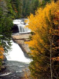
Section 1: To Triple Falls (Easy, 0.7 mi, 120 ft climb)
Note: Distances for sections 1-5 are there and back from the parking lot, and do not include the Preamble trip to Hooker Falls, so add 3/4 mile to your total hike if you decide to visit Hooker Falls first!

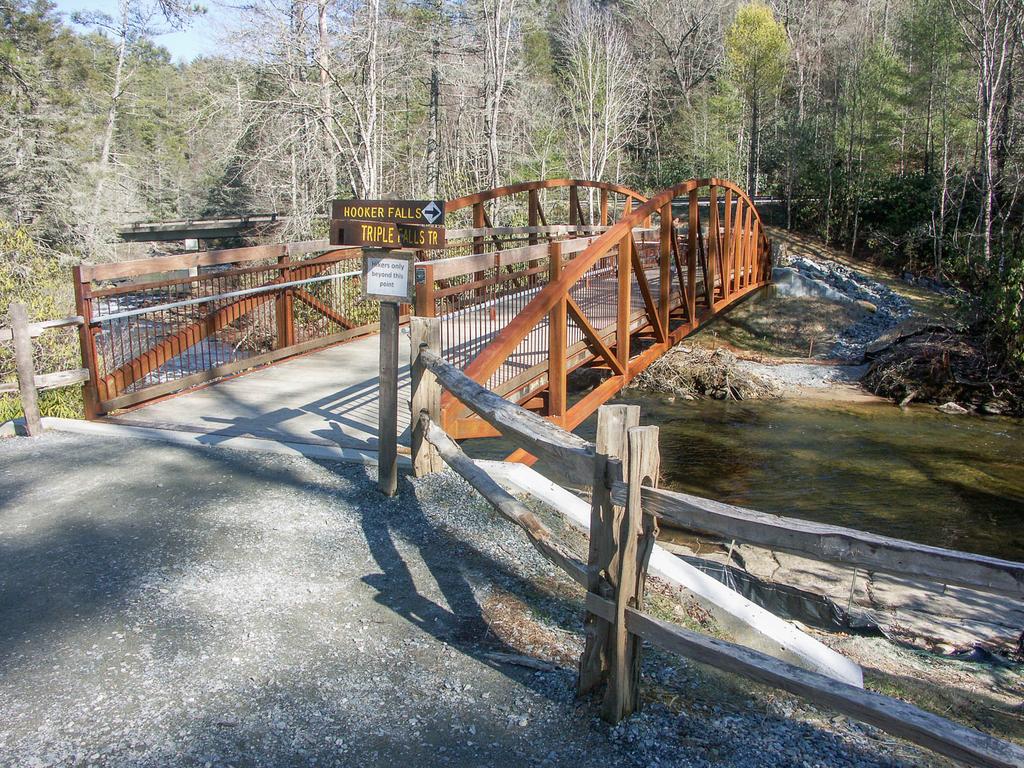
Begin by crossing the new wood and steel trail bridge over the Little River, which was added in July 2013 so hikers don't have to cross on the highway bridge anymore. On the other side, turn left on the Triple Falls trail and go under the highway bridge. The trail follows the Little River upstream into the forest.
Soon, you'll begin a short but quite steep climb up to the viewing area for Triple Falls, which is on the left directly beside the trail about 0.35 mi from the bridge. This is one of the best overlooks for the falls.
There are two points of interest past the overlook you might also want to check out: the picnic shelter (on the right) and the trail to the close-up view of the falls (on the left).
First is a short path leading to a picnic shelter with another excellent view of the falls - a great spot for a family lunch stop. Bring a picnic!
Next is the path leading down to the middle of the falls, via a long set of steps. Hear the roar of the river as it plunges from two tiers above you to a swirling pool at your level, and feel the ample wind and mist from the middle falls. You can explore the falls up-close from there, but stay on the large, dry, flat rock areas above where the lower cascade drops to the riverbed below.
Do NOT climb the rocks or go into the water. It's illegal, and people have been severely injured doing that here! Rocks that stay wet with spray can get slimy and very slippery, so stay on the dry areas.
Once you're done exploring Triple Falls, continuing on to High Falls is highly recommended. However, you may turn around here and return to your vehicle for an easy overall hike.

Section 2: To High Falls (Easy to Moderate, 1.9 mi, 240 ft climb)
High Falls is a spectacular sight. The water slides down a 150 ft high dome of exposed rock almost as wide; at several points, rooster tails launch streams of water into the air. To get to it, starting from the Triple Falls picnic shelter, go uphill on the gravel road for about 0.1 mi and take a left onto the High Falls trail.
This trail is mostly level, smooth and wide, with a few wet spots and a few rocks. The trail follows the Little River closely and it is amazing how calm and level it is between the two falls. About 0.3 mi from the turn, you'll reach the junction with the River Bend trail.
The best view of the falls is to the right on the High Falls trail after 0.2 mi steeply uphill.
To reach the base of High Falls, go left on the Riverbend Trail. The path starts out wide and level as it goes along the river, but gets a bit rockier and narrower as it comes out on the rocks around the pool at the base of the falls 0.32 mi from the High Falls trail.
Don't try to climb the rocks near the falls - there are plenty of safe places to enjoy the view. Use extreme caution if you decide to get in the water as many people do - the currents can be significant. When you're done exploring, return down the River Bend trail to the High Falls trail intersection. This adds about 0.6 mi to the hike.
You could return to your vehicle from here to keep this an easy hike; or, turn left on the High Falls trail to begin the moderate climb up to the High Falls overlook in 0.2 mi.
Just past the overlook, you can take the set of steps and a path uphill to the right to reach another picnic shelter, again with a great view.

If you are turning around here, backtrack on the High Falls trail to the Triple Falls trail. Turn right and follow the Little River back to the steel bridge and the parking area.
Section 3: to the Covered Bridge over the Little River (Moderate, 2.75 mi, 375 ft climb)
To get to the Covered Bridge visible above High Falls, follow either of the trails from the High Falls overlook or the picnic shelter uphill. Both trails join together in about 0.1 mi. Continue straight on the High Falls trail (a gentle climb on a gravel road) for 280 ft. to the Covered Bridge trail intersection. Turn left onto the Covered Bridge trail.
Covered Bridge trail climbs a bit more, goes back downhill, and then reaches Buck Forest Road in just under 1/4 mi. Turn left onto the wide Buck Forest Road to cross the covered bridge at the top of High Falls. On the right, you'll get a view of the calm, smooth river above the falls. On the left, you can see the river as it spills over the brink of High Falls.
Return by backtracking the Covered Bridge, High Falls, and Triple Falls trails if you're ending the hike here.

Section 4: To Lake Dense (Moderate, 4.5 mi, 525 ft climb)
The way to Lake Dense - called Conservation Road - was also planned to be a main subdivision road. Cross the covered bridge on Buck Forest Road and in about 250 ft, turn right onto Conservation Road. The road is level, wide, and kinda boring to hike. In less than 0.1 mi, turn left onto the Pitch Pine trail to follow a more interesting route to the lake. The Pitch Pine trail winds around through the forest, past some neat rock outcrops in cove and ridge settings, to reach Joanna Road in about 0.6 mi.
Cross Joanna Road and pick up the Pitch Pine trail again on the other side. The trail twists and turns down to Lake Dense, follows its northern shore in a westerly direction for a bit and then ends on the Three Lakes trail near the picnic shelter and dam, 0.35 mi from Joanna Road.
Lake Dense is a real gem. The water is crystal-clear, at least in cooler months (it greens up a bit in summer), and Joanna Mountain rising above the lake in the background makes for a spectacular scene. Bring your bathing suit - swimming is allowed and very inviting on a hot day! Hang out on the docks or perhaps enjoy a snack in the picnic shelter.
You may also continue along the same trail, across the dam, and through through the pines for another 0.3 mi on the Three Lakes trail to reach Lake Alford. This tiny pond is spring-fed and you can see right through its waters to the small fish which live in it.
If you're turning around here, the easiest route back is to skip the Pitch Pine trail, and instead take the Three Lakes trail back to Joanna Road; turn left; turn right on Conservation Road, then backtrack on Buck Forest Road, Covered Bridge Trail, High Falls Trail, and Triple Falls Trail.
Section 5: To Bridal Veil Falls (Moderate, 7.25 mi, 625 ft climb)

There is one more waterfall in the heart of DuPont: Bridal Veil Falls. To see it, take the Three Lakes trail past Lake Alford in 0.3 mi and continue uphill, south, past the spring feeding the small pond. The trail winds to the west past an arm of Lake Julia and then the spillway channel before reaching Conservation Road about 0.4 mi past Lake Alford.
Turn left on Conservation Road to cross the spillway on a bridge and traverse the old Reasonover Creek stream bed below the Lake Julia dam. Past the dam, the trail climbs a bit. About 0.45 mi from the Three Lakes trail, you'll reach the intersection with the Bridal Veil Falls at the horse barn area. This "trail" is another gravel road; turn right.
It's just over 1/2 mi to the falls; the gently rolling road ends in a roundabout and an easy gravel path continues straight toward the falls. Just past the Corn Mill Shoals trail junction, the path rounds a switchback to the base of the falls.
After you've seen enough - or you're forced to leave because of the time, like I always am - return to the parking area. The easiest route is to follow Bridal Veil Falls trail back to the horse barn; turn left on Conservation Road (skip the Three Lakes and Pitch Pine trails this time) and then backtrack on Buck Forest Road, Covered Bridge Trail, High Falls Trail, and Triple Falls Trail.
All Photos from This Hike


Map
Green highlight indicates the route to follow within the trail network for this hike.
Tip: Printing this map? You can pan and zoom the map as desired before printing to show the area you need.
Map Information
Download GPS Data
Click on a route, trail, or point on the map and select the GPS Data tab to download its data.
Data Formats
KML (Google Earth)
KML is the main file type used by Google Earth. If you have Google Earth installed, clicking the KML link should open the trail or point directly in Google Earth for viewing. This is the native file format used by Google Earth, but many other map applications can use and understand KML as well, so if you're not sure which one to download, KML is a good bet.
GPX
The GPX format stands for GPS Exchange - a free, open, XML format for exchanging GPS and map data. GPX is compatible with Google Earth, many other mapping programs, and most GPS devices (such as Garmin). Load the file directly into your GPS to help find your way on your next trip!
GeoJSON
GeoJSON is a newer, lightweight data exchange format which can be used to quickly share map data and may have a smaller size than KML or GPX. Many professional mapping and GIS applications support the GeoJSON format.
About the Map
Copyright
Base Layers
Base layers provided by OpenStreetMap, the US Geological Survey, the US Forest Service, and NC OneMap. Base layer images are subject to the respective copyright policies of their owners. Base layers may not be available at all times due to system maintenance or outages.
WNCOutdoors Base Layer
The WNCOutdoors Base layer is provided by WNCOutdoors.info. It is licensed by Creative Commons Attribution 3.0.
Trail and Marker Overlays
Trail layers and downloadable data are all original works created by WNCOutdoors with guidance from a variety of sources, including ensembles of our own GPS tracks, user contributed GPS tracks, official maps and GIS data from government agencies, and field observations. WNCOutdoors data is made freely available under the Open Database License - you are free to copy and use it for any purpose under the terms of that license (summary).
Tips
- Hover over a trail to see it highlighted. Helps to see start and end points for an individual trail.
- Scroll and zoom the map before printing, and that view will persist into the printed image.
- Click a trail for more details and to download it individually.
Feedback
Ratings
Average Rating: 3.8 (rated 31 times)
Rate It Now:

[Site Admin] Jordan M. said: @Audrey Culp We've updated the description with more precise distances and the *shortest route* round-trip figures based on our GIS map data, and also adds the Pitch Pine and Three Lakes trail to bypass the boring section of Conservation Road. Though you could easily do 13 miles of hiking on this trip, you can visit all the destinations listed here with an 8.0 mi hike round-trip (which includes Pitch Pine and Three Lakes one-way, and Conservation Road coming back). Adding on any of the side paths increases the mileage so I'd figure on 10 for an average hike which includes the base of the falls. We hope this helps!
Lisa Rea said: I would like to know if there are any camp sites or hotels or cabins nearby.
Jennybows said: About how long does it take to make the round trip for this hike. I seen roughly 13 miles together. And are there and spots where you can set up a small campsite along the way? Thanks.
Audrey Culp said: The trip was fantastic! Super fun with lots of chances to play in the waterfalls. I absolutely loved it. The only thing is that the total length is way way off. I hiked all 5 falls with my boyfriend and we tracked it on his iPhone and it was right at 13 miles round trip.
Karen said: Hiked the tour today /Aug 26. Fantastic!
Richie Lengel said: Thomas Cemetery Disaster An open letter to those who care to protect our state forest: My wife and I have been mountain biking at DuPont every week for several years. We drive up from Charlotte every week to do that. We LOVE this place! We contribute many dollars and many hours every year… doing are part to help maintain our beloved forest. Sometime around the middle of last winter heavy equipment moved in and started cutting down trees along Thomas Cemetery Rd. At first we didn’t pay much attention, thinking they were just cutting out a few old, diseased trees… or something? Surely this was approved by people much smarter than us? Then we noticed the activity was beginning to destroy the roadbed of one of our favorite downhill runs. We thought that surely they would be finished soon. However the months kept passing… and the destruction of the road and annihilation of the forest reached apocalyptic proportions. Then they purposely dropped several trees across the lower end of Thomas Cemetery in an attempt to limit traffic. My guess is someone thought if they limit traffic… even on the weekends when they weren’t chopping down trees… less people might notice the horrible mess they were making. Well that hasn’t worked. A LOT of people have noticed. A LOT of people want this destruction to stop immediately. It can’t be dismissed by the folks in charge with some lame excuse that they are “thinning out” the trees for the “health” of the forest… or something? I’ve been around and studied forests my whole life. One fact I’ve learned is indisputable… trees are good for forests. The time has come to stop this insanity and return DuPont to its owners… the people of North Carolina who pay the taxes and contribute directly to support it. I have two questions for anyone who cares to answer: 1. I would love to hear the reason this was approved and who approved it; and 2. When will this carnage end? A true friend of the forest. -Richie Lengel
Susan said: Where is the best area to be able to observe the blue fireflies?
hh said: Are there places to set up camp in these trails?
Angie said: Is any of the joke stroller friendly?
Michael Parker said: can I kayak on Cascade lake, and are there Trout in it? Thanks in advance.
Marty said: Are you allowed to camp on this wonderful trail?
Kay said: Does anyone know if the "tram" rides that take you near the falls are still available. I would like to take my elderly mother. Thanks
[Site Admin] Jordan M. said: Yes, the parking area is back open and the new trail bridge is in place. We've updated the description of this hike. Thanks!
Pete said: 7-17-2013. Is the Dupont Waterfalls Tour Hike open now?
deb fatkin said: Does anyone know if Hooker Falls is closed during Memorial weekend (May 26)? Where do you park to get to Triple Falls and High Falls?
[Site Admin] Jordan M. said: Thanks Bruce! And William, it looks like a great app!
William Modesitt said: Carolina Waterfalls on the iPhone! https://itunes.apple.com/us/app/carolina-waterfalls/id580563723?mt=8
Bruce said: There is one change of note. At High Falls, they removed the steep steps leading down to the base of the falls, and there's now a sign saying to reach the base of High Falls to take River Bend trail.
Jenn said: This was a great trip. There was much more water falling than I expected to see in December. Galax Trail was not an option, though, due to fallen trees blocking the entrance. Ascending the Triple Falls Trail instead was heart-pumping but do-able. The narrow trail to the base of High Falls is worth it if you are able, but be extremely careful if you venture out onto the rocks. I was cautious and still slid and fell on a slick patch. On the return trip down Triple Falls Trail, we also saw a flock of wild turkeys take off into the sky.
Dan said: Very emjoyable and can see 5 falls in one day for the adventurous. Or EASY to see 4. Grassy Creek ( 0.8 mile) and Bridal Veil ( 1.6 miles from Covered Bridge) are Easy because the elevation change is minimal and the path is a wide open, dirt road.
Eric said: It was okay. The trail keeps you from getting too close to Triple or High Falls, but puts you on an overlook literally on Grassy Creek Falls (which is great). But the trail to Grassy Creek Falls was treacherous (I went in a downpour) and potentially dangerous for over-zealous dogs.
Jay said: If you're traveling near Brevard, NC, don't miss the opportunity to see High Falls and Triple Falls. The hike is relatively easy and the views are absolutely spectacular. (Aside from the hikes described here, Dupont State Forest has dozens of other scenic trails.)