Hiking in Chimney Rock State Park
Overview
This new and growing state park is located on the edge of the Hickory Nut Gorge, around the monolithic rock formation which gives the area its name. Carved out of the side of the Blue Ridge, the Hickory Nut Gorge is an area of special geology and ecology and the park preserves some of the best of what this area has to offer.


Chimney Rock State Park is bifurcated into two areas: the tourist-oriented attraction area, which is still privately operated and charges an admission fee, and the state-managed outlying areas that are admission-free.
Fee Area: Chimney Rock at Chimney Rock State Park
The privately-managed area in the park is now known as Chimney Rock at Chimney Rock State Park.
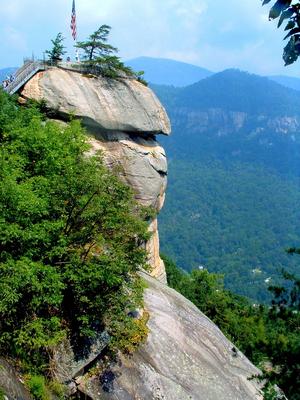
The park's namesake, a huge pillar of granite standing apart from the mountain, is located in the attraction area. It provides views that are are second to none from its flat top. You'll see the Gorge, the surrounding mountains, and the lake at the mouth of the gorge - Lake Lure.
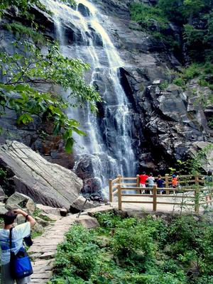
A second main landmark within the park is also within the attraction area - 404 ft Hickory Nut Falls. Both the Chimney and the Falls are dramatically visible from the highway and town of Chimney Rock below.
Admission Free Areas of the Park
A state-run area of the park, located across the Hickory Nut Gorge from the principal attraction area, is called the Rumbling Bald access. While Rumbling Bald has been used primarily by rock climbers wishing to utilize the mountain's famous boulders, it is open to all visitors. And it's more like a traditional state park than the Attraction area: it's in a more natural state, it's admission-free, and it offers one of the park’s six trails.
There is much more state-owned land outside the attraction which is not yet open to the public, but slated to become an important feature in the park's master plan.

History
Recent Developments
Many acres of land around the Hickory Nut Gorge had been purchased by the State of North Carolina with the intention of creating a new State Park. By 2005, the State had authorized the creation of Hickory Nut Gorge State Park across the gorge from the long-established, privately-owned Chimney Rock attraction.
In early 2007, the privately-owned Chimney Rock Park went up for sale, and was (thankfully) purchased from private ownership by the State to be added to the new and growing State Park. Sine the state now owned Chimney Rock Park, a much more recognizable name than Hickory Nut Gorge, the name of the entire park was changed to Chimney Rock State Park.
Due to its long tradition of being privately owned and the costs associated with the existing visitor amenities around Chimney Rock itself, a new private company was formed, Chimney Rock Management, LLC, to manage the visitor facilities in the Attraction area. This is a similar arrangement that was also used when Grandfather Mountain, another famous North Carolina tourist destination, was bought by the state. This arrangement (and the Attraction's entry fee) will remain in effect for the foreseeable future.
Hiking Trails
Hickory Nut Falls Hike


Hiking in the attraction area is rather unique, owing to the area's rugged terrain (it's basically located on the side of a cliff) yet need to appeal to a tourism-oriented audience.
Easy Options
To reach the Chimney itself by the most direct route, it's more of a stroll than a hike. You'll walk through a neat man-made tunnel in solid granite, ride an elevator 26 stories straight up, walk through a gift shop, and then take a cliff-top path leading to a set of steel and wood stairs to make the final ascent. (This route is wheelchair accessible up to the base of the stairs and chimney).
The Hickory Nut Falls trail has a natural surface and leads to one of the Park's best features. It's an easy 1.5 mile round-trip hike via the point where it connects to the road at the upper parking area, and it's one of the Best Hikes on this site.
The 0.6 mi Great Woodland Adventure trail has a natural surface with gentle climbs and is also perfect for kids. Starting at The Meadows, it is is a Kids In Parks TRACK Trail with lots of fun things to explore along the way.
More Difficult Options
Chimney Rock Tour Hike

Two of the so-called trails in the park - including the Outcroppings and Skyline trails - are primarily man-made steel and wood staircase structures, which wind their way straight up boulders and cliff faces! (The State has replaced many of the old, all-wood structures with new, sturdy ones for visitor safety and long-term stability of the structures themselves). Both offer fantastic scenery.
For hiking-oriented visits to Chimney Rock, we recommend parking at The Meadows and taking the Four Seasons trail, which has a mostly natural surface and a moderate climb, to the rest of the trail network. All the trails in the attraction area of the park can then be explored over the course of a moderate to more difficult day hike we call the Chimney Rock Tour, one of the Best Hikes on this site.
Even though these trails may seem short and highly developed to seasoned hikers, there is a lot of climbing and elevation change in the park, making them deceptively strenuous. But they're short, and it's all worthwhile - there is something great to see around every turn!
The Rumbling Bald trail, separate from the attraction area, is a recently-improved 1.5 mile loop trail which winds its way through a set of huge boulders at the base of Rumbling Bald Mountain.
This is just an overview of the trails in the park. For more details, visit the Chimney Rock Trails page.
Rumbling Bald Trail

Amenities
The park offers a variety of modern conveniences inside its Attraction area. Scattered along the Chimney Rock access road are tables and grills for picnicking. More developed amenities are in two main areas along the entrance road.
The Meadows
Just past the ticket plaza is The Meadows, an open area with views up to the top of the mountain. A picnic area, picnic pavilion, and restrooms are available at The Meadows. Use of the tables requires no extra fee and is on a first-come, first-served basis. The amenities here make this the perfect base for exploring the rest of the park on foot via the trails.
Be sure to stop in with the kids at Grady's Animal Discovery Den after hiking the Great Woodland Adventure trail to learn about animals in the park. There's also a rock climbing tower available for groups. (Advance reservations are required for climbing).
The Main Parking Area
The main parking area at the top of the entrance road provides the most direct access to the Chimney as well as access to the trail system. Located here is the tunnel to the elevator, the Cliff Dwellers and Sky Lounge gift shops (at the top and bottom of the elevator, respectively), a deli (open March - November), and restrooms.
Fees
Since long before the park was purchased by the State, a substantial fee has been charged to enter the "Attraction" area of the park. This will continue for the foreseeable future. Get more information about fees on the Park's official website.
Parts of the State Park that are not part of the original private tourist attraction, such as Rumbling Bald, do not require a fee for entry.
Map
Here's a map of the Chimney Rock State Park area. For more maps, including printed publications, see our Chimney Rock State Park maps page.
Map Information
Download GPS Data
Click on a route, trail, or point on the map and select the GPS Data tab to download its data.
Data Formats
KML (Google Earth)
KML is the main file type used by Google Earth. If you have Google Earth installed, clicking the KML link should open the trail or point directly in Google Earth for viewing. This is the native file format used by Google Earth, but many other map applications can use and understand KML as well, so if you're not sure which one to download, KML is a good bet.
GPX
The GPX format stands for GPS Exchange - a free, open, XML format for exchanging GPS and map data. GPX is compatible with Google Earth, many other mapping programs, and most GPS devices (such as Garmin). Load the file directly into your GPS to help find your way on your next trip!
GeoJSON
GeoJSON is a newer, lightweight data exchange format which can be used to quickly share map data and may have a smaller size than KML or GPX. Many professional mapping and GIS applications support the GeoJSON format.
About the Map
Copyright
Base Layers
Base layers provided by OpenStreetMap, the US Geological Survey, the US Forest Service, and NC OneMap. Base layer images are subject to the respective copyright policies of their owners. Base layers may not be available at all times due to system maintenance or outages.
WNCOutdoors Base Layer
The WNCOutdoors Base layer is provided by WNCOutdoors.info. It is licensed by Creative Commons Attribution 3.0.
Trail and Marker Overlays
Trail layers and downloadable data are all original works created by WNCOutdoors with guidance from a variety of sources, including ensembles of our own GPS tracks, user contributed GPS tracks, official maps and GIS data from government agencies, and field observations. WNCOutdoors data is made freely available under the Open Database License - you are free to copy and use it for any purpose under the terms of that license (summary).
Tips
- Hover over a trail to see it highlighted. Helps to see start and end points for an individual trail.
- Scroll and zoom the map before printing, and that view will persist into the printed image.
- Click a trail for more details and to download it individually.
Directions
From the North/West (Asheville and along the I-26 corridor)
Make your way to Asheville and take I-240 East to US 74A East. Follow 74A East for approximately 25 miles to the entrance for the Park in the town of Chimney Rock, on the right.
From the East
From the I-40 corridor - points east such as Hickory, Statesville, or Raleigh - take exit 103 for US Hwy. 64. Turn left and follow 64 West for just over 50 miles to the park entrance on the left in the town of Lake Lure. US 64 merges with Hwy. 74A in Rutherfordton; just stay on US 64 the whole way.
From the Charlotte area, take US Hwy. 74 East toward Forest City. Take exit 167 for NC Hwy. 9 North and go just under 12 miles to Lake Lure. Turn left on US Hwy. 64/74-A and go about 5 miles to the park entrance on the left.
From the South/West
Take I-26 West across the North Carolina border. Take Exit 67 for NC Hwy. 108 and go about 5 miles to NC Hwy. 9 North. Turn left on NC Hwy. 9 North and go about 9 miles to US Hwy. 64/74A. Turn left on US Hwy. 64/74A and go aout 5 miles to the park entrance on the left.
Map Information
Download GPS Data
Click on a route, trail, or point on the map and select the GPS Data tab to download its data.
Data Formats
KML (Google Earth)
KML is the main file type used by Google Earth. If you have Google Earth installed, clicking the KML link should open the trail or point directly in Google Earth for viewing. This is the native file format used by Google Earth, but many other map applications can use and understand KML as well, so if you're not sure which one to download, KML is a good bet.
GPX
The GPX format stands for GPS Exchange - a free, open, XML format for exchanging GPS and map data. GPX is compatible with Google Earth, many other mapping programs, and most GPS devices (such as Garmin). Load the file directly into your GPS to help find your way on your next trip!
GeoJSON
GeoJSON is a newer, lightweight data exchange format which can be used to quickly share map data and may have a smaller size than KML or GPX. Many professional mapping and GIS applications support the GeoJSON format.
About the Map
Copyright
Base Layers
Base layers provided by OpenStreetMap, the US Geological Survey, the US Forest Service, and NC OneMap. Base layer images are subject to the respective copyright policies of their owners. Base layers may not be available at all times due to system maintenance or outages.
WNCOutdoors Base Layer
The WNCOutdoors Base layer is provided by WNCOutdoors.info. It is licensed by Creative Commons Attribution 3.0.
Trail and Marker Overlays
Trail layers and downloadable data are all original works created by WNCOutdoors with guidance from a variety of sources, including ensembles of our own GPS tracks, user contributed GPS tracks, official maps and GIS data from government agencies, and field observations. WNCOutdoors data is made freely available under the Open Database License - you are free to copy and use it for any purpose under the terms of that license (summary).
Tips
- Hover over a trail to see it highlighted. Helps to see start and end points for an individual trail.
- Scroll and zoom the map before printing, and that view will persist into the printed image.
- Click a trail for more details and to download it individually.
