The Big Ivy (Coleman Boundary) Area
Overview
Big Ivy, long known by locals as Coleman Boundary, is a section of Pisgah National Forest below the Blue Ridge Parkway as it runs across the ridges of the Great Craggy Mountains to the east.

While the valley floor is around 2500 ft elevation, peaks in the range top out at over 6000 ft, making for a difference in elevation of over half a mile. This contributes to the variety of ecosystems found here, and the resultant rich, invigorating forest cloaks miles of trails ready for your exploration.


The area is wrapped around the upper reaches of the Ivy River. "Ivy" is a local name for mountain laurel, which grows here in abundance.
A wide variety of differing species of plants and animals exist in this area of rugged terrain. The forest growing in Big Ivy is especially rich, having an unusual origin for its soils.
Douglas Falls (Lower Approach) Hike


Hiking Trails
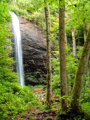
One of the area's most popular features is Douglas Falls. This spectacular, 70-foot free-falling waterfall makes an excellent destination for an easy family hike when approached from below. Or, you can take a difficult, day-long hike from the Craggy Gardens area of the Blue Ridge Parkway above. However you reach it, it's well worth a visit.
Those who approach from below will pass several other interesting features along the 8-mile long gravel access road. You'll see some smaller falls - notably Walker Falls which cascades directly beside the road - and the high cliffs of Snake's Den Rock, a popular climbing spot. The drive is almost as scenic as the hike, and passes several other trails.
Although the lower 1/2 mile of the Douglas Falls trail is by far the most used an popular in the area, many other trails can be found here. Nearly all of them connect to FS 74 and have enough room to pull off and park. The upper part of the Douglas Falls trail connects to the Mountains to Sea trail near Craggy Gardens, making a hike from the Parkway to the falls possible (but long, rough, and steep).
The Bear Pen, Corner Rock, Elk Pen, Perkins, Staire Creek, Little Andy, and Walker Creek trails climb through mixed forests from lower to higher elevations. There are streamside areas and drier areas on each, and they all follow old logging road beds. The Laurel Gap trail is more of a spongy, mossy gravel road and is less steep than the others. Loop options exist among the interconnecting trails as well.
This is just an overview of the trails in the area. For details on each individual trail, visit the Trails page or for what we consider to be the best hikes in the area visit the Hikes page.

History
The Big Ivy area is so unique it was - along with the Black Mountains just to the northeast - considered for National Park protection back in the 1930's along with the Great Smoky Mountains (which ultimately received that high status).
The main road, FS 74, has remnant CCC structures along its length and was probably built (or improved) in the first half of the 20th century. The Laurel Gap trail was created as a logging road during a spate of logging activity in the late 80's, making it one of the newer roads in the area.
The Elk Pen trail was created for the movie "The Last of the Mohicans", and used in the opening scene.
Filmmakers from 2012's "The Hunger Games" reportedly shot pre-Games scenes of Gale and Katniss in the Big Ivy area as well.
Map
Here's a map of the Big Ivy area. For more maps, including printed publications, see our Big Ivy maps page.
Map Information
Download GPS Data
Click on a route, trail, or point on the map and select the GPS Data tab to download its data.
Data Formats
KML (Google Earth)
KML is the main file type used by Google Earth. If you have Google Earth installed, clicking the KML link should open the trail or point directly in Google Earth for viewing. This is the native file format used by Google Earth, but many other map applications can use and understand KML as well, so if you're not sure which one to download, KML is a good bet.
GPX
The GPX format stands for GPS Exchange - a free, open, XML format for exchanging GPS and map data. GPX is compatible with Google Earth, many other mapping programs, and most GPS devices (such as Garmin). Load the file directly into your GPS to help find your way on your next trip!
GeoJSON
GeoJSON is a newer, lightweight data exchange format which can be used to quickly share map data and may have a smaller size than KML or GPX. Many professional mapping and GIS applications support the GeoJSON format.
About the Map
Copyright
Base Layers
Base layers provided by OpenStreetMap, the US Geological Survey, the US Forest Service, and NC OneMap. Base layer images are subject to the respective copyright policies of their owners. Base layers may not be available at all times due to system maintenance or outages.
WNCOutdoors Base Layer
The WNCOutdoors Base layer is provided by WNCOutdoors.info. It is licensed by Creative Commons Attribution 3.0.
Trail and Marker Overlays
Trail layers and downloadable data are all original works created by WNCOutdoors with guidance from a variety of sources, including ensembles of our own GPS tracks, user contributed GPS tracks, official maps and GIS data from government agencies, and field observations. WNCOutdoors data is made freely available under the Open Database License - you are free to copy and use it for any purpose under the terms of that license (summary).
Tips
- Hover over a trail to see it highlighted. Helps to see start and end points for an individual trail.
- Scroll and zoom the map before printing, and that view will persist into the printed image.
- Click a trail for more details and to download it individually.
Places to Stay
Camping
Dispersed camping is allowed anywhere within this section of the Pisgah National Forest, as long as you are 500 feet from designated trails, roads, and streams. There are several marked campsites along FS 74 which travels up to Douglas Falls. There are no developed campgrounds in the area.

Lodging
Dry Ridge Inn
Most important to your Asheville getaway is a warm welcome and courteous attention. This is what you will receive at the Dry Ridge Inn, located in Weaverville, NC. Our historical three story home has eight rooms and all include private baths, gas fireplaces, and Cable TV and DVD Player. Some can be combined to make suites for large families. Our bed and breakfast country inn is just a short drive from the Blue Ridge Parkway - ideal for recreation or simply to enjoy the enchantment of the Blue Ridge mountains. The Biltmore Estate and downtown Asheville are also just 10 minutes away, and the Coleman Boundary area is a scenic 20 minute drive. The inn provides a wonderful getaway for those romantic special occasions: honeymoons, an anniversary, or any other time when romance is in the air! Our desire is that your stay with us at our bed and breakfast accommodation be a comfortable, happy, and memorable one. You will find our home comfortable, food delicious and our spacious grounds inviting and relaxing. Enjoy a book on the porch swing or gaze into the water garden and let the waterfall soothe you.
http://www.dryridgeinn.com
Wolf Branch Cabin
This cabin is located 34 miles (or a 40-minute drive) north of downtown Asheville, on 25 private acres surrounded by trees & water. The cabin is about 12 miles from the Appalachian Trail where it crosses Sam's Gap at the NC/TN state line. Enjoy soaking in the hot tub on the deck while listening to the creek, which runs right in front of the cabin. This cabin has 2 bedrooms. The main BR is in the loft with a skylight over the bed - great for stargazing! The kitchen & 1.5 baths are fully equipped. Amenities include a gas grill, satellite TV, XM radio, extensive movie, book & CD collection, gas fireplace, W&D, privacy, and much more. Linens are provided plus Pets are Welcome!
http://www.wolfbranchcabin.com/
Directions
From Asheville
Take US 19/23 north/I-26 west for about 11 miles. Take exit 15 for Jupiter/Barnardsville (NC Hwy. 197). Turn right toward Barnardsville and follow NC 197 about 6 miles to the town of Barnardsville. Turn right onto Dillingham Road just past the old fire station and the downtown area. It's about 6 miles from here to the National Forest - stay on Dillingham Road the whole way. You will want to bear left where Haw Branch Road goes straight; left again at Dillingham Presbyterian Church and the Stony Fork Road intersection; right just past the church at Town Branch Road after crossing a narrow bridge. The road will cross two more narrow bridges and then turn into gravel FS 74, which marks the Forest Service boundary. It's 8 miles from there to the Douglas Falls parking area.
From the Craggy Gardens Area on the Blue Ridge Parkway
Many people find out about Douglas Falls and the Big Ivy area from the Craggy Gardens Visitor Center on the Blue Ridge Parkway. Starting at the visitor center, drive 2.2 miles south on the Parkway to the Craggy Gardens Picnic Area access road and turn right. Go about 1/4 mile to the top of the hill and turn left onto gravel Forest Service Road 63 (Stony Fork Road). (The gate may be closed during winter/wet/snowy weather, in which case you're out of luck). Go 6.4 miles down the mountain to the intersection with Dillingham Road at the Presbyterian Church mentioned above, and turn right. It's 1.3 miles to the National Forest entrance and FS 74.
