Looking Glass Rock Hike

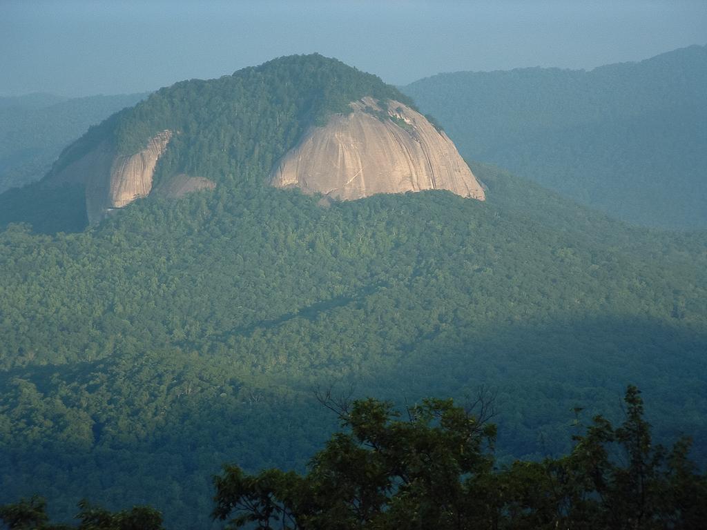
This hike takes you to the top of a Pisgah National Forest icon: the huge granitic pluton known as Looking Glass Rock. Visible from many locations along the Blue Ridge Parkway and found on postcards in every gift shop in the region, the summit of the rock provides a spectacular vista of the surrounding mountains and valleys. As such, this challenging hike has been one of the most popular in the area for a long time.
At A Glance
 6.4 mi round-trip
Difficulty Rating: 10.39 ![]()
Tread Condition: Moderately Rough ![]()
Climb: Climbs Steeply ![]()
Lowest Elevation: 2320 ft
Highest Elevation: 3969 ft
Climb Total: 1649 ft
Configuration: Out-and-back
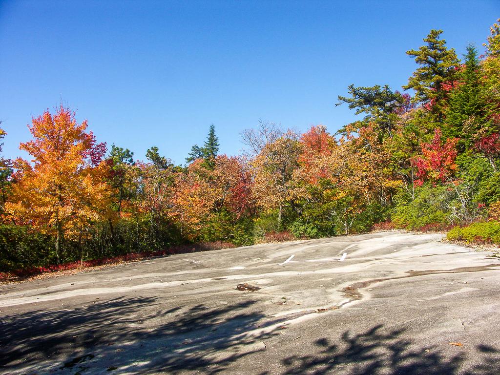
Starting Point: Parking Area on FR 475
Trails Used: Looking Glass Rock
Hike Start Location
Directions
From Asheville, NC, take I-240 west to I-26 east to the exit for the Asheville Airport (exit 40). Turn right onto NC 280; follow this 4-lane highway for 16 miles toward Brevard. At the intersection with US highways 276 and 64, turn right onto US 276 west (follow signs for Pisgah National Forest). Follow US 276 for 5.2 miles; turn left onto FR 475. The trailhead parking area is on the right after 0.4 miles.
Details
Hike Description
Begin the hike on the signed Looking Glass Rock trail at the back of the parking lot, which begins with some steps. There is only one trail, which leads all the way to the top.
The trail enters an open forest once consisting of mostly hemlock trees. These are now dead, so other species are beginning to grow and take up their space. The dead trunks still stand, so until they are completely down, watch for falling limbs, especially on windy days.
This hike isn't really known for being a water hike, but it starts by going uphill in a cove beside a small stream. This stream drains the left side of the small ridge you'll generally follow all the way up to the summit of the mountain. It runs crystal clear - when it's not dried up! The trail swings right to cross the creek on a footbridge, then ascends the ridge on the opposite side.

On this lowest section of the hike, the trail does climb, but only moderately so, and the surface is in generally good condition. You'll come around the ridge, and climb into the cove on the other side, where a larger stream flows. There are actually some nice yet small cascades on this creek during high water. Climbing upstream, the trail is high above the water on a narrow bench on the hillside. At times, it dips into side coves where it crosses some small wet-weather seeps, but no real tributaries.
Soon the trail hits the first of the many switchbacks you will encounter on your way up, and at this point the woods are thin and open. You'll be able to see the trail both below and above you as you begin winding in and out of small side coves. There are so many switchbacks that the trail never really becomes extremely steep.

As you climb, the switchbacks become tighter and more frequent and generally stick to the face of the small ridge. The forest transitions into more of a mesic one, and the trees higher up are a bit shorter than down below.
About 1/3 of the way to the top of the mountain, you'll reach a left-hand switchback with a large Carolina hemlock anchoring the tip of it. Just past the hemlock is a 30 ft sheer drop-off. You have a limited view from here of the cliffs on the north side of the mountain. Below you, during wet weather, a small trickle of water chuckles over the rocks, almost forming a waterfall. It goes without saying to be careful here if you explore near the hemlock.
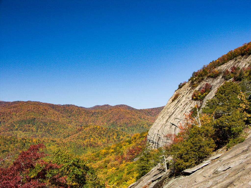
At this point, you're starting to ascend a steep band of rocks which just about completely surround the mountain. The mountain is a ridge, shaped kind of like whale surfacing from a sea of trees around it, with the part you're climbing being near the tail. The nose would be where the highest cliffs are located - and where you'll end up for the final view.
The slope is not quite as steep back on this side, which is why trees can grow on it and why the trail was built over here; on the mountain's other aspects, this cliff band are pretty much vertical and treeless. You can't see much along this section, except for some limited views in winter.
For the next few switchbacks, you'll be ascending this steeper part of the slope. The forest around the steep area consist largely of Carolina hemlocks. This is a relatively rare tree which thrives in the thin soils and high exposure areas of North Carolina's rocky mountainsides. In fact, this tree is only found in southwestern Virginia, eastern Tennessee, western North Carolina, and very small areas of upstate South Carolina and Georgia.

The trail curves into a small cove carved into the top of the ridge, with a gulch at the bottom that is dry most of the time. You'll pass a nice, large campsite on your left, then swing left and ascend the side of the cove. You're approaching the halfway point of the hike right about here, and the trail is becoming steeper and rougher as it starts ascending along the spine of the ridge.
Almost everywhere you go in the Southern Appalachian mountains, you find rhododendron and mountain laurel shrubs. There is no lack of those here either; they really become noticeable as you get higher up on the ridge. The trail slips off to the left side of the main ridge line and then you will cross a small, wet-weather tributary. When it runs, it must plunge over a waterfall at some point downstream considering that you're above the cliff band at this point. If there is water here - which there seldom is - enjoy it because there is no more along the rest of the trail.
Beyond the tributary - or damp spot - you'll swing back and forth through switchbacks as you start to pass and cross over some of the large rock slabs which characterize the top of this mountain. After a sharp left hand turn, you'll pass a flat rock slab on your left which is used as a helicopter pad, and is marked with a big "H" painted on it. And at the edge of the helipad, carved deeply into the rock, is the following text:
MAX WILSON
3-9-30
10-30-55
Mike Bailey kindly sent us the following comment on the origin of this text:
"Max" was from Asheville, NC, and was a former US Marshal (among other things). He was bigger than life and a wonderful, generous man. My brother-in-law was with Max when he "chiseled" his initials and dates into the flat granite there at the heli-pad location. Max told me on a hike up there in 1965 that he wanted to carve more "but he ran out of beer."
For this reason, you'll sometimes hear people refer to this as Max Wilson Rock.
The final push to the top of the mountain beyond the helipad is somewhat steep and eroded, so watch your footing. The actual summit itself is somewhat unimpressive - it's round and almost flat, covered by oak, mountain laurel, and rhododendron. It doesn't even quite reach 4000' in elevation (at only 3969' above sea level), so there's kind of a letdown in that, too. But there is a nice campsite on the left, just before the top. The trail will actually start downhill again before it emerges from the forest atop the major cliffs on the west-northwest face of the mountain.
The Carolina Hemlock really looks like it belongs here. You can distinguish it from the more common Eastern Hemlock by the stiffer needles which emerge from the stem at all angles, rather than in a flat plane. Its seeds are the longest of any of the native hemlocks. Adapted to the harsher conditions in which it grows, it has stiffer twigs than the Eastern Hemlock. And it has an overall shape more similar to alpine species including spruces and firs which live at higher elevations and farther north.
A few of them have fallen due to high winds in recent years. And sadly, the Hemlock Woolly Adelgid infestation is well underway here and has taken a few more, and threatens to kill the rest of them without intervention. But many of the trees on Looking Glass have been treated with insecticides and adelgid-eating predator beetles may also be in the area. As of fall 2016, many of the Carolina hemlocks on Looking Glass remain healthy and green. Let's hope they can stay that way!
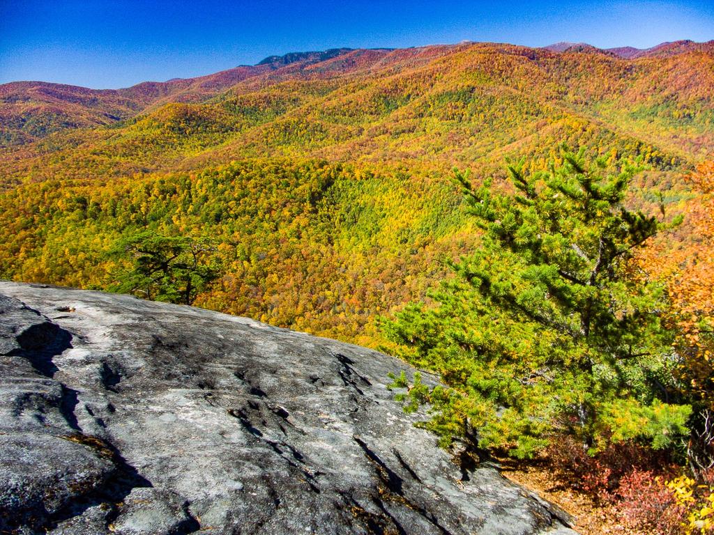

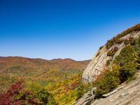
Once you pop out on the cliffs, you'll immediately see why this hike is so popular. The view is, of course, wonderful. Be careful and stay on the flatter rock at the edge of the forest, which isn't too risky if it's dry. Be especially wary if you have kids or dogs with you - it is a long way down once you go over the edge.
You'll be looking out toward the Pisgah Ridge and can see the Blue Ridge Parkway and Black Balsam Mountain looming above you. At your feet, small gullies have been carved into the rock by water seeping out of the mat of roots, soil, rocks, and forest duff that forms a thin cap on top of the mountain. Watch out for patches of water, algae, pine needles, or ice on the rock that could send you sliding as you search for that perfect spot for a photograph!
When you are finished soaking up the view, return to your vehicle via the same trail.
All Photos from This Hike


Map
Green highlight indicates the route to follow within the trail network for this hike.
Tip: Printing this map? You can pan and zoom the map as desired before printing to show the area you need.
Map Information
Download GPS Data
Click on a route, trail, or point on the map and select the GPS Data tab to download its data.
Data Formats
KML (Google Earth)
KML is the main file type used by Google Earth. If you have Google Earth installed, clicking the KML link should open the trail or point directly in Google Earth for viewing. This is the native file format used by Google Earth, but many other map applications can use and understand KML as well, so if you're not sure which one to download, KML is a good bet.
GPX
The GPX format stands for GPS Exchange - a free, open, XML format for exchanging GPS and map data. GPX is compatible with Google Earth, many other mapping programs, and most GPS devices (such as Garmin). Load the file directly into your GPS to help find your way on your next trip!
GeoJSON
GeoJSON is a newer, lightweight data exchange format which can be used to quickly share map data and may have a smaller size than KML or GPX. Many professional mapping and GIS applications support the GeoJSON format.
About the Map
Copyright
Base Layers
Base layers provided by OpenStreetMap, the US Geological Survey, the US Forest Service, and NC OneMap. Base layer images are subject to the respective copyright policies of their owners. Base layers may not be available at all times due to system maintenance or outages.
WNCOutdoors Base Layer
The WNCOutdoors Base layer is provided by WNCOutdoors.info. It is licensed by Creative Commons Attribution 3.0.
Trail and Marker Overlays
Trail layers and downloadable data are all original works created by WNCOutdoors with guidance from a variety of sources, including ensembles of our own GPS tracks, user contributed GPS tracks, official maps and GIS data from government agencies, and field observations. WNCOutdoors data is made freely available under the Open Database License - you are free to copy and use it for any purpose under the terms of that license (summary).
Tips
- Hover over a trail to see it highlighted. Helps to see start and end points for an individual trail.
- Scroll and zoom the map before printing, and that view will persist into the printed image.
- Click a trail for more details and to download it individually.
Feedback
Ratings
Average Rating: 3.5 (rated 31 times)
Rate It Now:

Jenny said: To reiterate, I would like to clarify that the Max Wilson who carved his name on the rock at the helipad was not the Max Wilson that was previously claimed (who was a US Marshall, and if you research, wasn't even born until 1929, which would make him a BABY when my grandfather first chiseled his name and date into the rock in 1930. That mans own daughter even disputed the story about it being him in this thread!) Max G. Wilson of Pisgah Forest was the man who actually did this. He was my grandfather (my mother's father.) He was born in 1912 and lived here for most of his life (also lived in Smokemont for a few years for work) He was a park ranger, as was his father, Charlie W. Wilson (also from the area) and later worked for Charlie Picklesimer at Citizens Telephone Company in Brevard.
Joseph Smith said: Me and a 85 year old friend hike looking glass rock june 2017 of this year. it was a blast. i had no ideal how fun this hike was. i took pictures of the max wilson name,thought that was pretty neat. very dangerous hike for an eldery man, but we enjoyed it very much. my friend did very well all the way up and 3/4 down, had to help him down the last 500 feet. he did very good for an 84 year old man.
Eileen said: I recently hiked this trail with my nephew and his father in memorial for husband. It was nothing like the time I hiked it in 1985 3 times and May 1992 and camped out. It is much more dangerous because there is not enough rock to sit on when a crowd gets there. It is easy to fall off the rock to your death. It happened on Aug. 23, 2015 when a 68 yr old man was walking around the rock and then disappeared. He fell 400' to the base of the mountain. [http://www.citizen-times.com/story/news/local/2015/08/23/sc-man-dies-foot-fall-looking-glass-rock/32231759/] This is all the rock that you get to sit on:[http://internetbrothers.org/images/lower_looking_glass_full.jpg]. This was on Jeff Clark's Meanderthals Hiking Blog web site about Looking Glass Trail similar to this one. [http://internetbrothers.org/2011/10/17/looking-glass-rock-trail-pisgah-national-forest/]I wrote Jeff Clark and told him I thought it was dangerous to go on this rock. And I wrote the Pisgah National Forest. In 1985, I hiked it 3 separate times spring, summer and fall. Then in May 1992, I camped out with my husband and it was great. It was beautiful. Unfortunately, I cannot find a picture of the rock that we sat on, But I did find a side view of the mountain that shows the rock face that we sat on the top and had the entire rock to walk on. Most people like to climb but the rock is protected for the peregrine falcon on the North Face and Victory Wall. [http://carolinaclimbers.org/climbing-areas/looking-glass-rock/looking-glass-rock.html]
Bryan Turner said: Please stay on trail and don't use the switchback "shortcuts".
Pam said: My husband and I hiked Looking Glass Rock in May 2016. We are from the very flat South Florida, so we weren't sure how difficult "difficult" was. But, we've hiked all over Sedona and through Yosemite so figured we'd give it a shot. I imagine this trail is probably difficult for people who don't hike or aren't very fit, but if you exercise regularly it isn't a problem. There are a lot of switchbacks at one point, but fortunately there are shortcuts through each one. We used a few of those on the way down. The trail is clear and very well marked. It's a very peaceful hike too. We made it to the top and over to the rock face where we had a sit for a little while. The entire time we were sitting, it felt like gravity was trying to suck us over the edge! Overall a long and peaceful hike with lots of scenery and wildlife (snakes).
Cheryl said: We hiked this mountain in the summer of 2007. I am from S.C. and my then boyfriend was from Boston. We were both in our early 50s! It was a wonderful hike going up, although as we got deep into the hike it became hotter and hotter. It was interesting to see the terrain changing as we continued to climb higher. Reaching the top was an esoteric experience for us both. We sat on the rock and contemplated life and love. By this time we were had removed all our clothes and were only in shorts and tank tops. I suppose we enjoyed the view at the top too long because as we started out hike back down, we realized we needed to get to the trail head quickly because darkness was coming. We tried to skip switch backs to make better time and in doing so we sorta/kinda got lost. We spent most of the time sliding down the side as we held onto vines, branches, bushes, trees. I was a newbie hiker so I didn't realize how lost or how close we were to having to spend the night on the trail (with no food or water). I followed his foot prints the entire time. We never argued...we stayed focus on what we had to do. Finally as twilight was quickly faded into darkness, we saw car headlights! Exhilaration overcame us. We were still down to the bare minimum of clothing....caked and covered with mud and sweat and scratches. Across the highway was a pond where we jumped in (sans clothing). It was the most refreshing swim I have even had. He and I are no longer together but this is a hike that will remain etched in my memory for the rest of my life.
Michael Croese said: Great write up, went on the hike today 10/20/15 perfect temp. You will be climbing all the way to the top. Good work out... Coming from Florida. Great day hike, on the way out go to the hub store. Great Bernard outdoor store that also serves local craft beer.
Mark said: It's a nice fairly easy hike for a beginner or family. The view at the top is very nice, but not spectacular. For a greater challenge I would recommend Table Rock, I thought the views were better there as well.
CC VT said: Great weather, great trail, just a little muddy. Hiked 1-8-15 for stats. Ran into est. 30-40 people, 22-16 dogs. Personally I did a lot of falling down the mountain. Ron is a kind soul. Read labels on your medication!
Jenny said: Youre welcome Kristy :) My grandfather didnt drink either, and I think that says alot about the accountability of the first story.
Kristy Wilson said: Thank you, Jenny. I knew that was not my dad. He was a US Marshal, but hated beer. He would have remembered doing something like that.
David Oppenheimer said: Aerial photos of snow on Looking Glass Rock by Performance Impressions Photography Archives - http://www.flickr.com/photos/livemusicphotography/sets/72157632775883638/
Jenny said: Im back after speaking with my mom, Christine, who is Max Wilson's daughter. I wanted to make sure I got my story completely straight before saying anything else. My grandfather was not a park ranger at the time he carved his name in the rock, as I stated before, but his father, Charlie W. Wilson was. It WAS definitely my grandfather who carved his name and these dates though, because my mother was with him as a teenager when he chiseled the date from 1955. She says he had planned to do it each time they went, but so often they ended up there without planning ahead and did not bring a chisel.
Jenny said: My grandfather is the Max Wilson who carved his name on Looking Glass rock. He was not from Asheville, he was from Pisgah Forest (he also spent some time in Smokemont, TN.) He was a park ranger when the parkway was being put in, and I think that he was helping out with that project around the time he carved his name on the rock. I know beyond a shadow of a doubt that is was him, that would be why the other Max Wilson doesnt remember doing it. I know it may seem trivial, but Im adding this because so much of the story of our heritage is already so twisted by falsities like this, and I would like make sure the truth is known, when I can help it.
Pablo said: Can I camp there? I'm a photographer and looking for cliffy places to set up my one-man tent, camp, and document it.
Bike-N-Hike said: I made the hike in mid May of 2012. I rode down from Maine on my F650GS. Thanks for the detailed write up of the hike and GPS data. I really enjoyed the hike and the area around Brevard.
Michelle Miller said: Great hike! Not for the faint of heart. Definitely one of my favorites!!
samantha gray said: i am a native to nc and i have lived right below looking glass rock all my life and im going this sunday to hike to the top im so super excited
Steve Hancock said: I'm from Georgia visiting family in the area and was able to check out this hike today. Very nice hike and the view is tremendous! It was a cold morning and the nose was covered with ice so I wasn't able to venture out. The sun hadn't reached that side of the rock by that time but my guess is a nice sunny day like today would melt by early afternoon. It has been wet recently so the trails have more water than I expected but not enough to break out my waterproof boot and my trail shoes work adequate for this hike. Enjoyed it!
Ted Hughes said: I was 5 in the Summer of '69 on vacation with my family when I first saw Looking Glass Mountain. Over the years I kept telling myself I would climb that. Realizing I am not getting any younger... my girlfriend and I hiked up there in July 2011. It was awesome!I took some great photos. I learned to carry more water next time for July... but I can't wait to climb it again!
Kristy Wilson said: I am Max's daughter and I asked him about doing this and he did not remember. I would love to know if it was really him.
Jordan said: Thanks for the information, Mike! Very interesting!
Mike Bailey said: Good write up on trail hike. I hike it at least once a year (just got back from doing it today). "Max" was from Asheville, NC, and was a former US Marshal (among other things). He was bigger than life and a wonderful, generous man. My brother-in-law was with Max when he "chiseled" his initials and dates into the flat granite there at the heli-pad location. Max told me on a hike up there in 1965 that he wanted to carve more "but he ran out of beer."