Lower Sidehill Trail

At A Glance


3.1 mi one-way
Difficulty Rating: 3.1 ![]()
Steepness: Hilly ![]()
Tread Condition: Some Obstacles ![]()
Trail Number: 137A
Description
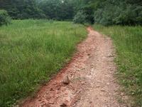
A steep climb near the south end gives way to a sidehill traverse, mostly on old road beds, before descending to lower elevations and smaller hills near the north end. This is one of the more remote-feeling sections of trail in Bent Creek. Passes through a varied forest - from dry pine/oak to moist hemlock/cove hardwoods. Rocky areas and a couple of stream crossings. Passes near research plots, grassy fields, and logged areas.
Intersecting Trails
This trail is located in the Bent Creek area. For a list of all the trails in that area, see the Bent Creek trails list page.
All Photos from the Trail


GPS Map
Map Information
Download GPS Data
Click on a route, trail, or point on the map and select the GPS Data tab to download its data.
Data Formats
KML (Google Earth)
KML is the main file type used by Google Earth. If you have Google Earth installed, clicking the KML link should open the trail or point directly in Google Earth for viewing. This is the native file format used by Google Earth, but many other map applications can use and understand KML as well, so if you're not sure which one to download, KML is a good bet.
GPX
The GPX format stands for GPS Exchange - a free, open, XML format for exchanging GPS and map data. GPX is compatible with Google Earth, many other mapping programs, and most GPS devices (such as Garmin). Load the file directly into your GPS to help find your way on your next trip!
GeoJSON
GeoJSON is a newer, lightweight data exchange format which can be used to quickly share map data and may have a smaller size than KML or GPX. Many professional mapping and GIS applications support the GeoJSON format.
About the Map
Copyright
Base Layers
Base layers provided by OpenStreetMap, the US Geological Survey, the US Forest Service, and NC OneMap. Base layer images are subject to the respective copyright policies of their owners. Base layers may not be available at all times due to system maintenance or outages.
WNCOutdoors Base Layer
The WNCOutdoors Base layer is provided by WNCOutdoors.info. It is licensed by Creative Commons Attribution 3.0.
Trail and Marker Overlays
Trail layers and downloadable data are all original works created by WNCOutdoors with guidance from a variety of sources, including ensembles of our own GPS tracks, user contributed GPS tracks, official maps and GIS data from government agencies, and field observations. WNCOutdoors data is made freely available under the Open Database License - you are free to copy and use it for any purpose under the terms of that license (summary).
Tips
- Hover over a trail to see it highlighted. Helps to see start and end points for an individual trail.
- Scroll and zoom the map before printing, and that view will persist into the printed image.
- Click a trail for more details and to download it individually.
Trail Segments
Trails are often made up of several connecting paths which may have different characteristics, allowed uses, and seasons. This trail is divided into multiple segments as follows:
Lower Sidehill - SW
- Allowed Uses: Hiking, Mountain Biking, Horseback Riding
- Length: 1.71 mi
Lower Sidehill - NE
- Allowed Uses: Hiking, Mountain Biking, Horseback Riding
- Length: 0.7 mi
Total Calculated Length: 2.4 mi
This value is derived from our underlying map data, and it may not match officially published information.
Feedback
Ratings
Average Rating: 5.0 (rated 1 times)
Rate It Now:

Mandy Warren said: If you're looking for a bit of a challenge than this one is perfect! Beautiful views! However it is a bit steep with loose gravel and lots of mud so I'd definitely be careful. Otherwise it's tons of fun.
Scottyray said: Not rideable up very steep with loose rock and slick dirt. The decent will raise you heart level fast as it is very steep.