Mackey Mountain Trail

At A Glance


8 mi one-way
Difficulty Rating: 8 ![]()
Steepness: Hilly ![]()
Tread Condition: Moderately Rough ![]()
Blaze Color: Orange (sparse)
Trail Number: 216
Description
The infamous Mackey Mountain trail starts near the top of Curtis Creek Road and heads southeast. This trail begins well enough, winding along and across the ridgeline past Sams Knob and over to Narrows Knob. It's a well-graded path in most places, but (as of 2016) the blazes and the trail fade away more and more the farther you go. The trail becomes all but indistinct before essentially petering out in several directions once reaching Mackey Mountain itself.
There are no maintained connections toward the southern end of Mackey Mountain trial, but there are several potential connections you could make back east down to Mackey Creek, south to Stillhouse Branch, or north to Locust Creek via old, abandoned routes. This should all be considered wilderness travel past Narrows Knob.
Intersecting Trails
This trail is located in the Curtis Creek area. For a list of all the trails in that area, see the Curtis Creek trails list page.
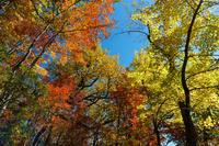
All Photos from the Trail


GPS Map
Map Information
Download GPS Data
Click on a route, trail, or point on the map and select the GPS Data tab to download its data.
Data Formats
KML (Google Earth)
KML is the main file type used by Google Earth. If you have Google Earth installed, clicking the KML link should open the trail or point directly in Google Earth for viewing. This is the native file format used by Google Earth, but many other map applications can use and understand KML as well, so if you're not sure which one to download, KML is a good bet.
GPX
The GPX format stands for GPS Exchange - a free, open, XML format for exchanging GPS and map data. GPX is compatible with Google Earth, many other mapping programs, and most GPS devices (such as Garmin). Load the file directly into your GPS to help find your way on your next trip!
GeoJSON
GeoJSON is a newer, lightweight data exchange format which can be used to quickly share map data and may have a smaller size than KML or GPX. Many professional mapping and GIS applications support the GeoJSON format.
About the Map
Copyright
Base Layers
Base layers provided by OpenStreetMap, the US Geological Survey, the US Forest Service, and NC OneMap. Base layer images are subject to the respective copyright policies of their owners. Base layers may not be available at all times due to system maintenance or outages.
WNCOutdoors Base Layer
The WNCOutdoors Base layer is provided by WNCOutdoors.info. It is licensed by Creative Commons Attribution 3.0.
Trail and Marker Overlays
Trail layers and downloadable data are all original works created by WNCOutdoors with guidance from a variety of sources, including ensembles of our own GPS tracks, user contributed GPS tracks, official maps and GIS data from government agencies, and field observations. WNCOutdoors data is made freely available under the Open Database License - you are free to copy and use it for any purpose under the terms of that license (summary).
Tips
- Hover over a trail to see it highlighted. Helps to see start and end points for an individual trail.
- Scroll and zoom the map before printing, and that view will persist into the printed image.
- Click a trail for more details and to download it individually.
Trail Segments
Trails are often made up of several connecting paths which may have different characteristics, allowed uses, and seasons. This trail is divided into multiple segments as follows:
Mackey Mountain - Cutis Creek Road to Narrows Knob
- Allowed Uses: Hiking
- Length: 1.72 mi
Mackey Mountain - Mackey Mountain to End
- Allowed Uses: Hiking
- Length: 4.11 mi
Mackey Mountain - Narrows Knob to Mackey Mountain
- Allowed Uses: Hiking
- Length: 1.02 mi
Total Calculated Length: 6.85 mi
This value is derived from our underlying map data, and it may not match officially published information.
Feedback
Ratings
Average Rating: 4.5 (rated 2 times)
Rate It Now:

Thomas Mabry said: We hiked from Curtis Creek Road to the Summit of Mackey Mountain and a bit beyond. The trail past Narrows Knob is discernible but the final push to the summit is more of a glorified Bushwack. On the other side of the summit going down toward Poplar Ridge, The trail is easy to lose despite being flagged and it’s rough due to a recent fire. All said, yes, it’s difficult but the joy is having a multifaceted hike with a few good views and a rarely travelled path. 6.88 miles RT, 1650 vertical feet