Snooks Nose Trail

At A Glance


4 mi one-way
Difficulty Rating: 9.94 ![]()
Steepness: Climbs Steeply ![]()
Tread Condition: Moderately Rough ![]()
Lowest Elevation: 1850 ft
Highest Elevation: 4750 ft
Climb Total: 2900 ft
Blaze Color: Yellow
Trail Number: 211
Description
Starting the Curtis Creek campground, the trail winds its way into the cove containing Slick Falls Branch on an old logging road, and then begins its signature climb. This is one steep trail! There are a few switchbacks, but they don't minimize the grade much at all. After passing Slick Falls on the right - which is nearly impossible to get a good view of - the trail curves across a ridge, where there is a small clearing and junction of old roads. Keep to the right here. The trail then levels out some, but only briefly. The steepest part of the climb is yet to come.
After resuming the super-steep climb on the old logging road system, the trail passes a large rock face on the left, then transitions into a purpose-built trail which is much more comfortable to hike. This section is narrower, and passes through switchbacks, easing the grade somewhat. After a pronounced turn to the north, the trail pops out of the denser forest onto the exposed ridge called Snooks Nose.
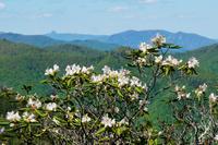
Views from Snooks Nose are fantastic, mostly to the east toward Linville Gorge and to the west toward the Blue Ridge and Black Mountains. Many people make an out-and-back hike with 3625 ft Snooks Nose as the destination, making for a hike of about 4 miles and a 1775 ft climb.
However, if you really want to earn summit bragging rights, the trail does continue up the ridge to cross 4300 ft Laurel Knob. It then descends a bit before climbing yet again to reach the Blue Ridge Parkway at the Green overlook. You can continue to the summit of Green Knob (the ultimate culmination of the Snooks Nose ridge) via a 0.2 mi section of the Green Knob trail, located about 100 yards north along the Parkway on the left. Summiting Green Knob this way makes for a 9 mile out-and-back hike with an overall climb of 3240 ft (not counting a couple hundred for ups-and-downs), going all the way up the Blue Ridge - and rivaling some of the toughest single-trail climbs in the region!
This trail is located in the Curtis Creek area. For a list of all the trails in that area, see the Curtis Creek trails list page.
This trail also crosses into these trailhead areas:
All Photos from the Trail


GPS Map
Map Information
Download GPS Data
Click on a route, trail, or point on the map and select the GPS Data tab to download its data.
Data Formats
KML (Google Earth)
KML is the main file type used by Google Earth. If you have Google Earth installed, clicking the KML link should open the trail or point directly in Google Earth for viewing. This is the native file format used by Google Earth, but many other map applications can use and understand KML as well, so if you're not sure which one to download, KML is a good bet.
GPX
The GPX format stands for GPS Exchange - a free, open, XML format for exchanging GPS and map data. GPX is compatible with Google Earth, many other mapping programs, and most GPS devices (such as Garmin). Load the file directly into your GPS to help find your way on your next trip!
GeoJSON
GeoJSON is a newer, lightweight data exchange format which can be used to quickly share map data and may have a smaller size than KML or GPX. Many professional mapping and GIS applications support the GeoJSON format.
About the Map
Copyright
Base Layers
Base layers provided by OpenStreetMap, the US Geological Survey, the US Forest Service, and NC OneMap. Base layer images are subject to the respective copyright policies of their owners. Base layers may not be available at all times due to system maintenance or outages.
WNCOutdoors Base Layer
The WNCOutdoors Base layer is provided by WNCOutdoors.info. It is licensed by Creative Commons Attribution 3.0.
Trail and Marker Overlays
Trail layers and downloadable data are all original works created by WNCOutdoors with guidance from a variety of sources, including ensembles of our own GPS tracks, user contributed GPS tracks, official maps and GIS data from government agencies, and field observations. WNCOutdoors data is made freely available under the Open Database License - you are free to copy and use it for any purpose under the terms of that license (summary).
Tips
- Hover over a trail to see it highlighted. Helps to see start and end points for an individual trail.
- Scroll and zoom the map before printing, and that view will persist into the printed image.
- Click a trail for more details and to download it individually.
Feedback
Ratings
Average Rating: 5.0 (rated 5 times)
Rate It Now:

No comments yet.