Coontree Loop Trail

At A Glance


")
3.7 mi one-way
Difficulty Rating: 3.7 ![]()
Steepness: Climbs Moderately ![]()
Tread Condition: Some Obstacles ![]()
Blaze Color: Blue
Trail Number: 144
Description
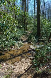
Pleasant loop; you can take this one in either direction but my preference is clockwise. Nothing spectacular, just typical creekside, mountainside and ridgetop landscapes, but it is nicely varied. Loop travels up one cove and down another. Joins with Bennett Gap trail for portion along the ridge. Mostly hemlock/cove hardwood forests near the bottom, mostly oak forest near the top with plenty of mountain laurel groves.
Intersecting Trails
This trail is located in the Davidson River area. For a list of all the trails in that area, see the Davidson River trails list page.
All Photos from the Trail


GPS Map
Map Information
Download GPS Data
Click on a route, trail, or point on the map and select the GPS Data tab to download its data.
Data Formats
KML (Google Earth)
KML is the main file type used by Google Earth. If you have Google Earth installed, clicking the KML link should open the trail or point directly in Google Earth for viewing. This is the native file format used by Google Earth, but many other map applications can use and understand KML as well, so if you're not sure which one to download, KML is a good bet.
GPX
The GPX format stands for GPS Exchange - a free, open, XML format for exchanging GPS and map data. GPX is compatible with Google Earth, many other mapping programs, and most GPS devices (such as Garmin). Load the file directly into your GPS to help find your way on your next trip!
GeoJSON
GeoJSON is a newer, lightweight data exchange format which can be used to quickly share map data and may have a smaller size than KML or GPX. Many professional mapping and GIS applications support the GeoJSON format.
About the Map
Copyright
Base Layers
Base layers provided by OpenStreetMap, the US Geological Survey, the US Forest Service, and NC OneMap. Base layer images are subject to the respective copyright policies of their owners. Base layers may not be available at all times due to system maintenance or outages.
WNCOutdoors Base Layer
The WNCOutdoors Base layer is provided by WNCOutdoors.info. It is licensed by Creative Commons Attribution 3.0.
Trail and Marker Overlays
Trail layers and downloadable data are all original works created by WNCOutdoors with guidance from a variety of sources, including ensembles of our own GPS tracks, user contributed GPS tracks, official maps and GIS data from government agencies, and field observations. WNCOutdoors data is made freely available under the Open Database License - you are free to copy and use it for any purpose under the terms of that license (summary).
Tips
- Hover over a trail to see it highlighted. Helps to see start and end points for an individual trail.
- Scroll and zoom the map before printing, and that view will persist into the printed image.
- Click a trail for more details and to download it individually.
Trail Segments
Trails are often made up of several connecting paths which may have different characteristics, allowed uses, and seasons. This trail is divided into multiple segments as follows:
West Half
- Allowed Uses: Hiking
- Length: 1.52 mi
East Half
- Allowed Uses: Hiking, Mountain Biking
- Length: 0.95 mi
Co-signed with Bennett Gap Tr.
- Allowed Uses: Hiking, Mountain Biking
- Length: 0.59 mi
Extension to US 276/Picnic Area
- Allowed Uses: Hiking, Mountain Biking
- Length: 0.2 mi
Total Calculated Length: 3.26 mi
This value is derived from our underlying map data, and it may not match officially published information.
Feedback
Ratings
Average Rating: 4.0 (rated 5 times)
Rate It Now:

Sharon K Stafford said: My sister and I hiked this lollypop loop during prime April wildflower season, seeing lots of foamflower, halberd-leaved violets, wood anemone, branch lettuce, jack-in-the-pulpit, and Shuttleworth's ginger (Hexastylis). Also saw both vernal dwarf iris and dwarf crested iris, along with showy orchis. The trail was dry this day, but I suspect the eastern arm of the loop would be very slick right after a rain, since it is bare clay surface on a steep grade in many places. Fairly strenuous in places, especially if you go counter-clockwise. A beautiful hike for a beautiful spring day, regardless.
David and Donna Sharrits said: This was a very much enjoyable hike especially when reaching the top where it looks like you are walking underneath a canopy of laurels, rhododendrons. It was beautiful! It has become a little more difficult for us now and we will miss hiking it. We are enjoying the less difficult trails now. Great experience and memories! 💖
Matt Jabs said: My wife and I loved this hike. We came into the loop via Bennett Gap (Avery Creek Rd. entrance), around the loop, then back down the same portion of Bennett Gap. It was a great hike. We especially loved hiking uphill on the winding west side of the loop. One time we were startled by a flock of grouse flying out of a thicket a few feet from us!