Pilot Rock Trail

At A Glance


3.6 mi one-way
Difficulty Rating: 3.6 ![]()
Steepness: Climbs Steeply ![]()
Tread Condition: Moderately Rough ![]()
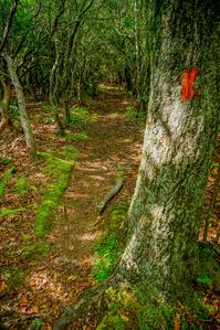
Blaze Color: Orange
Trail Number: 321
Description
Climbs somewhat steeply from Yellow Gap Road (FR 1206) up to the Buck Spring/Mountains to Sea trail near Mount Pisgah on the Parkway. Initially crosses a creek, then climbs through a cove forest gradually getting farther from it. Passes through many switchbacks along the way to the top of the dry ridge, some of which are engineered with dry-stacked rock walls and cobblestone fill. You'll also pass through natural block fields, resulting from the shedding of rocks and boulders from cliffs high up above.
An official spur trail leads to the base of Pilot Rock - the largest outcrop for which this trail is named - primarily for climbers. Other unofficial spurs lead to the top of Pilot Rock and nearby rock outcrops, providing spectacular views. Mid- and high-elevation mixed hardwood forests and northern hardwood forests start to take over as you climb, and the trail winds through thickets of twisted mountain laurel.
Beyond the Laurel Mountain Connector, passes through a dead stand of beech trees before reaching the open, grassy summit of Little Bald Mountain, 1900' above the trail's start at Yellow Gap Road. It will be noticeably cooler at the top than the bottom most days. The trail then descends a short distance down the north slope to reach the Mountains to Sea/Shut-In trail at its end.
Overall, this is an excellent trail which can be combined with others in the area - including Laurel Mountain and Thompson Creek - for loop hikes.
Intersecting Trails
This trail is located in the Mills River area. For a list of all the trails in that area, see the Mills River trails list page.
This trail also crosses into these trailhead areas:
All Photos from the Trail


GPS Map
Map Information
Download GPS Data
Click on a route, trail, or point on the map and select the GPS Data tab to download its data.
Data Formats
KML (Google Earth)
KML is the main file type used by Google Earth. If you have Google Earth installed, clicking the KML link should open the trail or point directly in Google Earth for viewing. This is the native file format used by Google Earth, but many other map applications can use and understand KML as well, so if you're not sure which one to download, KML is a good bet.
GPX
The GPX format stands for GPS Exchange - a free, open, XML format for exchanging GPS and map data. GPX is compatible with Google Earth, many other mapping programs, and most GPS devices (such as Garmin). Load the file directly into your GPS to help find your way on your next trip!
GeoJSON
GeoJSON is a newer, lightweight data exchange format which can be used to quickly share map data and may have a smaller size than KML or GPX. Many professional mapping and GIS applications support the GeoJSON format.
About the Map
Copyright
Base Layers
Base layers provided by OpenStreetMap, the US Geological Survey, the US Forest Service, and NC OneMap. Base layer images are subject to the respective copyright policies of their owners. Base layers may not be available at all times due to system maintenance or outages.
WNCOutdoors Base Layer
The WNCOutdoors Base layer is provided by WNCOutdoors.info. It is licensed by Creative Commons Attribution 3.0.
Trail and Marker Overlays
Trail layers and downloadable data are all original works created by WNCOutdoors with guidance from a variety of sources, including ensembles of our own GPS tracks, user contributed GPS tracks, official maps and GIS data from government agencies, and field observations. WNCOutdoors data is made freely available under the Open Database License - you are free to copy and use it for any purpose under the terms of that license (summary).
Tips
- Hover over a trail to see it highlighted. Helps to see start and end points for an individual trail.
- Scroll and zoom the map before printing, and that view will persist into the printed image.
- Click a trail for more details and to download it individually.
Trail Segments
Trails are often made up of several connecting paths which may have different characteristics, allowed uses, and seasons. This trail is divided into multiple segments as follows:
Pilot Rock - BRP Boundary to MST
- Allowed Uses: Hiking
- Length: 0.42 mi
Pilot Rock - Thompson Creek to BRP Boundary
- Allowed Uses: Hiking, Mountain Biking
- Length: 0.34 mi
Pilot Rock - Laurel Mt. Connector to Thompson Creek
- Allowed Uses: Hiking, Mountain Biking
- Length: 0.13 mi
Pilot Rock - FS 1206 to Laurel Mt. Connector
- Allowed Uses: Hiking, Mountain Biking
- Length: 2.29 mi
Total Calculated Length: 3.18 mi
This value is derived from our underlying map data, and it may not match officially published information.
Feedback
Ratings
Average Rating: (rated 0 times)
Rate It Now:

No comments yet.