Big Lost Cove Cliffs Trail

At A Glance


1.2 mi one-way
Difficulty Rating: 1.2 ![]()
Steepness: Hilly ![]()
Tread Condition: Some Obstacles ![]()
Trail Number: 271
Description
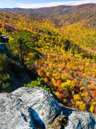
Ascends moderately through mixed hardwoods and then runs slightly downhill along the crest of the ridge on an old logging road. It descends steeply for a brief stretch into the flats right above the cliffs, in an open oak forest. There are a couple of old logging roads that diverge here; keep left at a couple of faint intersections to reach a fantastic viewpoint at the top of the cliffs. Grandfather Mountain looms in the background above Lost Cove. Stay back from the edge and don't trample the moss that grows between the rocks.
This trail is located in the Wilson Creek Area area. For a list of all the trails in that area, see the Wilson Creek Area trails list page.
All Photos from the Trail


GPS Map
Map Information
Download GPS Data
Click on a route, trail, or point on the map and select the GPS Data tab to download its data.
Data Formats
KML (Google Earth)
KML is the main file type used by Google Earth. If you have Google Earth installed, clicking the KML link should open the trail or point directly in Google Earth for viewing. This is the native file format used by Google Earth, but many other map applications can use and understand KML as well, so if you're not sure which one to download, KML is a good bet.
GPX
The GPX format stands for GPS Exchange - a free, open, XML format for exchanging GPS and map data. GPX is compatible with Google Earth, many other mapping programs, and most GPS devices (such as Garmin). Load the file directly into your GPS to help find your way on your next trip!
GeoJSON
GeoJSON is a newer, lightweight data exchange format which can be used to quickly share map data and may have a smaller size than KML or GPX. Many professional mapping and GIS applications support the GeoJSON format.
About the Map
Copyright
Base Layers
Base layers provided by OpenStreetMap, the US Geological Survey, the US Forest Service, and NC OneMap. Base layer images are subject to the respective copyright policies of their owners. Base layers may not be available at all times due to system maintenance or outages.
WNCOutdoors Base Layer
The WNCOutdoors Base layer is provided by WNCOutdoors.info. It is licensed by Creative Commons Attribution 3.0.
Trail and Marker Overlays
Trail layers and downloadable data are all original works created by WNCOutdoors with guidance from a variety of sources, including ensembles of our own GPS tracks, user contributed GPS tracks, official maps and GIS data from government agencies, and field observations. WNCOutdoors data is made freely available under the Open Database License - you are free to copy and use it for any purpose under the terms of that license (summary).
Tips
- Hover over a trail to see it highlighted. Helps to see start and end points for an individual trail.
- Scroll and zoom the map before printing, and that view will persist into the printed image.
- Click a trail for more details and to download it individually.
Feedback
Ratings
Average Rating: 3.0 (rated 3 times)
Rate It Now:

Nubs Parrot said: Went with my friend and got lost!!
Lacey said: This trail was such a fun hike. It doesn't seem to be hiked often so there are some obstacles such as fallen trees and narrow paths but it will get your heartbeat up for sure! Walking on the trail gives you beautiful views of the hardwoods but the cliffs are for sure the highlight of this trip. We took a picnic lunch with us to enjoy at the top. Pictures do not do justice to this beautiful place! If you are looking for a peaceful hike with a great view, this is it! Remember to take the first right, then take all lefts. There is a steep descend as you are appaorching the cliffs.
Erin S said: Such an amazing trail. The top makes this my favorite trail of all time. The beginning is very washed out and has gotten worse in the 30 years I've been hiking it. It's also narrow and needs to be cleaned out. At least as of August 2016. It's difficult but my 3.5 year old did it and only had to be carried a bit and she was in a bad mood. Head right at the first split then left at all others.