Potato Knob Fields Hike

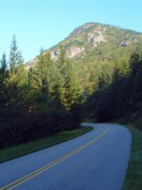
A well-known area landmark, Potato Knob is a rocky, prominent peak visible from the Blue Ridge Parkway, many points in the foothills region, and along I-40. This hike takes you on a spectacular section of the Mountains to Sea Trail below the peak with views at the end. You'll go through a pleasant spruce-fir forest, some of which was planted as a reforestation effort after the mountains were logged. The trail itself is a marvel, as gigantic rocks have been moved to form the trail surface. This trail is suitable for families with older children; younger kids may have difficulty on some of the rocky sections. Makes a great alternative to the over-crowed Craggy Gardens and Craggy Pinnacle hikes just south on the Parkway.
At A Glance
 2 mi round-trip
Difficulty Rating: 2.94 ![]()
Tread Condition: Moderately Rough ![]()
Climb: Climbs Moderately ![]()
Lowest Elevation: 5370 ft
Highest Elevation: 5720 ft
Climb Total: 350 ft
Configuration: Out-and-back
Starting Point: Parking Area on NC 128, just off the Blue Ridge Parkway
Trails Used: Mountains to Sea Section 3
Hike Start Location
Directions
From Asheville, take the Blue Ridge Parkway north for 27 miles to the entrance for Mount Mitchell State Park. Turn left onto NC 128, and go 0.6 mi. The trailhead is at the crossing of the Mountains to Sea Trail; there is a parking pulloff on the right. The trail ascends a set of steps across the road (on the left as you drive in).
Details
Hike Description
Start the hike by ascending the stairs across the road from the parking pulloff. You will see the sign for the Mountains to Sea Trail, and this trail follows white circular blazes. You will immediately pass through a staggered fence designed to keep large animals (e.g., horses) off the trail. The trail is well-blazed, and it is not difficult to stay on course.

The trail turns back to the left (south) in a grassy area, then ascends gently through a grove of spruce to reach the ridgeline. From the very start, you will notice how well this trail was built. Its design sheds water at all possible locations, and the trailbed is "outsloped" - meaning water runs across and off the edge of the trail rather than down the length of the trail. This means the trail is not eroded, an unusual state for trails at this elevation to be in, making the walk that much more pleasant. The entire trail up to the meadows is similarly built - in fact, most new sections of the Mountains to Sea Trail are this way.
As you approach the ridge, you'll notice the tall, straight spruce trees, whose dark appearance from afar in comparison to other trees give the Black Mountains their name. However, many of the spruces on this section are not the area's native Red Spruce which once grew here - they are Norway Spruce, imported from Europe and planted after the Black Mountains were logged in the early 20th century.
Valuable for its soft, resilient, slightly reddish wood, the Red Spruce were logged extensively during World War II and used for airplane propellers, leaving the mountains denuded. When it later became clear that the widespread logging was destructive to the mountain environment here, Norway spruce were selected for replanting due to their similarity to the native spruces but faster growth rate.
The two species can be distinguished (among other ways) by looking at their limb structure. The Norway spruces have conspicuously drooping twigs along the main limbs, while the Red Spruces do not.

Although the Norway Spruce are not natives, they are not really as invasive as some other non-native species in the region - they will survive if planted, but don't seem to readily sprout from seeds on their own this far south. (The problem is worse in the Northeast and southern Canada). Indeed, most of the young trees you'll see - even near the edges of the Norway spruce stands - are native Red Spruce.
A third alpine coniferous tree, the native Fraser Fir, is also seen growing beside the trail all the way up to the overlook at the end of this hike. Its longer, softer needles make it distinguishable from either of the spruces.
As you walk up the pleasant, gently sloping ridgeline on a grassy trail, you'll pass through several small openings in the forest. You'll also pass the boundary markers for the Blue Ridge Parkway property, downhill to your left.

The trail swings off the right side of the ridge in short order, and this is where some of the more remarkable trail structures can start to be seen. The trail was built by members of the Carolina Mountain Club (CMC), who took no shortcuts and keep it beautifully maintained. The CMC is one of the oldest, largest, and most active hiking and trail-related clubs in the region, and their efforts should be greatly appreciated when enjoying hikes such as this!
At one point a seep or small stream - which can cease flowing during very dry spells - oozes beneath a stone bridge. Massive stone steps carry you up around a switchback and back over the same seep once again. There are more of these types of trail structures up ahead.
The trail will round the main ridge once more and come out of the spruces. The forest you will be traveling through now is more of a mixed high-elevation forest with mostly young trees. Stands of short, straight American Beech trees, where the ground is covered with soft grass, appear at points along the way.
The beeches are under attack by a non-native disease complex consisting of an insect and fungus working in cohorts with one another. Just like the Fraser Firs, the American Chestnuts (now completely devastated), the Dogwoods and the Hemlocks, the ultimate fate of the beeches after the disease spreads everywhere they grow is still unknown.

Luckily, a few of the beech trees do seem to be naturally resistant to the disease - unlike the Hemlocks, Fraser Firs, and Chestnuts, which experience nearly 100% mortality due to their respective killers. Look for brown or orange colored leaves on affected trees during mid to late summer, often times sprinkled with the bright green of new growth as the trees attempt to recover. All the while, some individual trees remain remarkably unaffected.
Interspersed within the forest are open areas that are, at certain times of the year, overgrown with wildflowers and blackberries. This is also where you will catch your first views of the valley below off to your left. The valley is the Asheville Watershed, and the large lake at the bottom of it is the Burnett Reservoir. Asheville has one of the cleanest water sources of any city in the country thanks to these forests, and the watershed is said to protect the largest contiguous stands of Red Spruce forest in the Southern Appalachians. The steep, rocky peak above you to the right is Potato Knob (summit elevation 6420').
The trail begins to descend a bit, passing some rock outcrops on the right side, and then enters what's known as a "block field" - an area where stacks of rocks and boulders have fallen from cliffs or steep mountain peaks up above. These stone fragments were pried loose by freeze-thaw action, mainly during the last ice age.
Massive slabs of stone had to be moved to form the trail's surface. It's hard to imagine just how much effort went into hustling these boulders in to place for us to enjoy a nice, clear path across the rugged mountainside. Luckily, the trail surface here should pretty much never erode, ensuring future generation will be also able to admire this handiwork. The trail descends through a short s-curve entirely on massive, stair-stepped stones.

As you approach a ridge line arising from the slope below Potato Knob, the trail will climb through another s-curve with some stone steps, and then a spectacular view opens up to the left from a rocky outcropping.


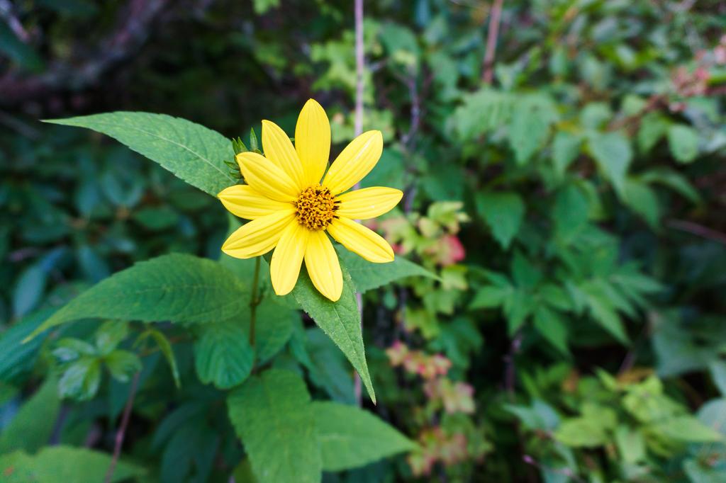
Continue just a couple hundred feet further up the trail through a grove of spruce and rhododendron to another opening which, during the spring and summer, is just brimming with wildflowers. You'll find (among others) Blackberry, Raspberry, Turk's Cap Lily, Daisy, Coneflower, Thistle, Bee Balm, St. John’s Wort, and Goldenrod (which blooms early this high up).

A large, obvious boulder sits alone in the shrubby meadow on the left side of the trail. A small side path leads up to the rock, and with a few footholds you can climb up on top of it. This rock marks the official end of this hike.

However, if you've still got some energy, the Mountains to Sea trail continues straight ahead and plunges back into deep, dark, mossy green spruce and fir forests as it resumes its (steeper) climb. It ascends to the top of the main Black Mountains ridge west of (a) Potato Knob, before going down through (b) Rainbow Gap and up to (c) Blackstock Knob. These would make nice extended destinations along this section of the Mountains to Sea Trail for longer hikes, with round-trip distances of about (a) 4, (b) 5 and (c) 7 miles from NC 128, respectively.

Enjoy the views, maybe have a snack and take some time to get re-hydrated, and then head back down to your vehicle the way you came to finish the hike.
All Photos from This Hike


Map
Green highlight indicates the route to follow within the trail network for this hike.
Tip: Printing this map? You can pan and zoom the map as desired before printing to show the area you need.
Map Information
Download GPS Data
Click on a route, trail, or point on the map and select the GPS Data tab to download its data.
Data Formats
KML (Google Earth)
KML is the main file type used by Google Earth. If you have Google Earth installed, clicking the KML link should open the trail or point directly in Google Earth for viewing. This is the native file format used by Google Earth, but many other map applications can use and understand KML as well, so if you're not sure which one to download, KML is a good bet.
GPX
The GPX format stands for GPS Exchange - a free, open, XML format for exchanging GPS and map data. GPX is compatible with Google Earth, many other mapping programs, and most GPS devices (such as Garmin). Load the file directly into your GPS to help find your way on your next trip!
GeoJSON
GeoJSON is a newer, lightweight data exchange format which can be used to quickly share map data and may have a smaller size than KML or GPX. Many professional mapping and GIS applications support the GeoJSON format.
About the Map
Copyright
Base Layers
Base layers provided by OpenStreetMap, the US Geological Survey, the US Forest Service, and NC OneMap. Base layer images are subject to the respective copyright policies of their owners. Base layers may not be available at all times due to system maintenance or outages.
WNCOutdoors Base Layer
The WNCOutdoors Base layer is provided by WNCOutdoors.info. It is licensed by Creative Commons Attribution 3.0.
Trail and Marker Overlays
Trail layers and downloadable data are all original works created by WNCOutdoors with guidance from a variety of sources, including ensembles of our own GPS tracks, user contributed GPS tracks, official maps and GIS data from government agencies, and field observations. WNCOutdoors data is made freely available under the Open Database License - you are free to copy and use it for any purpose under the terms of that license (summary).
Tips
- Hover over a trail to see it highlighted. Helps to see start and end points for an individual trail.
- Scroll and zoom the map before printing, and that view will persist into the printed image.
- Click a trail for more details and to download it individually.
Feedback
Ratings
Average Rating: 4.6 (rated 7 times)
Rate It Now:

Austin said: Beautiful trail through 'enchanted forests' with lovely grasses, wildflowers and berries and no poison ivy! However the Carolina Mountain Club sign was nowhere to be found on any of the rocks at the overlooks causing us to walk farther thinking we had missed the final overlook. If you continue on trail beyond the first mile described you go up to huge rocky ledges with a large cavy area in deep shady forest with no overlooks. Trail is amazingly laid out with so many stepping stones to climb but not advisable for small children much beyond the overlook at 1 mile. If you venture into forest beyond overlook, be sure to pay attention to the white circle trail markers to avoid taking a wrong turn around some of the bends. Only drawback was on a Saturday, there is too much noise pollution from loud motorcycles. Next time we will go on a quieter weekday or earlier morning .
Jana said: One of the most beautiful trails in the area. We hiked past the designated end of this hike and the trail kept getting more beautiful and more diverse. The only reason I did not rate it 5 stars is because of the traffic noise that can be heard for the first mile of the hike due to its proximity to the Blue Ridge Parkway. Still worth it and highly recommended. :)