Mount Pisgah Hike

A classic Blue Ridge Parkway hike, this trail continues onto National Forest land to climb to the summit of one of the area's most well-known peaks, which lends its name to numerous other things throughout the region. Mount Pisgah is part of the original tract of land sold by the Vanderbilts to the federal government to establish Pisgah National Forest. Easily visible from most of downtown Asheville, Mount Pisgah's 5721 ft summit supports the transmission tower for WLOS-TV, channel 13. The trail itself is a rocky, steep climb through Northern hardwood forests, and rhododendron and mountain laurel tunnels, to the summit where 360 degree views await!
At A Glance
 3 mi round-trip
Difficulty Rating: 4.83 ![]()
Tread Condition: Moderately Rough ![]()
Climb: Climbs Moderately ![]()
Lowest Elevation: 4980 ft
Highest Elevation: 5730 ft
Climb Total: 750 ft
Configuration: Out-and-back
Starting Point: Mount Pisgah Parking Area, Blue Ridge Parkway milepost 407.6
Trails Used: Mount Pisgah
Hike Start Location
Directions
From Asheville, take the Blue Ridge Parkway south to the Mount Pisgah Parking Area, on the left, at milepost 407.6. Park at the second parking area; the first is for the Buck Springs trail.
Details
Hike Description
The trail starts at the back of the parking area behind the large sign board. At the parking lot, you are just shy of 5000 ft in elevation and you are in the midst of the high-elevation northern hardwood forest. You will be in this forest, largely dominated by oaks, all the way to the summit - although you will see some birches, maples, beeches, spruce, and many other less common species mixing in at times.

In the first half of the hike, you will gain about 200 ft in elevation. The other 550 ft are gained in the second half, so the second half is much steeper. The entire hike is very rocky. There are some rooty and wet sections as well.
The trail begins a gentle climb along the slopes of Little Pisgah Mountain. The trees are a bit taller here than on the summit, but still quite gnarled and twisted. Some of them are hollow, and you may see animals (or people!) inside. As usual in these mountains, the sound of a rushing stream not far away can be heard. This particular stream is in the valley to your left as you wrap around the upper part of its watershed.
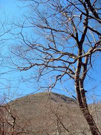
This stretch of trail offers wintertime views of Mt. Pisgah itself. In the summer, the cool, high-elevation woods offer a nice respite from the heat even if you don't hike all the way to the top.

You will reach the crest of the ridge between Little Pisgah Mountain and Mount Pisgah itself, and begin the more difficult part of the climb. This is where many turn back. The trail ahead travels up the ridgeline for a while where it becomes moderately steep. Then, you'll slip off the south side of the ridge onto on a very steep section of trail. There are some difficult step-ups and off-camber rocky sections. This is the steepest part of the climb.
After the climb moderates some, the trail will enter a long mountain laurel tunnel. It's not as steep, but it is still very rocky - almost one big rock staircase. The trail achieves a side ridge, switches back and then follows this ridge to the top of the summit, making a few turns through a stand of American Beech trees.
At the summit, you'll find the transmission tower for WLOS-TV, channel 13, and an observation deck. This kind of ruins any feeling of being in the wilderness, but the view is spectacular. On a clear day, you can see the parking area, the Campground & Pisgah Inn to the east; the Shining Rock Wilderness Area to your west (with Cold Mountain at its northern end); the Great Smoky Mountains farther to the west; and to the north, the city of Asheville, Craggy Mountains, and Mount Mitchell.

When you're finished soaking up the views, return to your vehicle on the same path.
Connecting Trails: Those staying at the Pisgah Inn can walk from the Inn north on the Buck Spring trail for 1.4 miles, past the old Buck Spring Lodge site, to the Mt. Pisgah Parking Area. From there, you can hike on up Mt. Pisgah itself. From the parking area, the Shut - In trail also heads north along the Blue Ridge Parkway toward Asheville. The Shut-In trail is the original route from the Biltmore Estate to the Buck Spring lodge, built as a mountain getaway for George Vanderbilt, owner of the famous Biltmore. The North Carolina Mountains to Sea Trail follows both the Buck Spring and Shut-In trails, and connects to trails in Pisgah National Forest in both directions.
All Photos from This Hike


Map
Green highlight indicates the route to follow within the trail network for this hike.
Tip: Printing this map? You can pan and zoom the map as desired before printing to show the area you need.
Map Information
Download GPS Data
Click on a route, trail, or point on the map and select the GPS Data tab to download its data.
Data Formats
KML (Google Earth)
KML is the main file type used by Google Earth. If you have Google Earth installed, clicking the KML link should open the trail or point directly in Google Earth for viewing. This is the native file format used by Google Earth, but many other map applications can use and understand KML as well, so if you're not sure which one to download, KML is a good bet.
GPX
The GPX format stands for GPS Exchange - a free, open, XML format for exchanging GPS and map data. GPX is compatible with Google Earth, many other mapping programs, and most GPS devices (such as Garmin). Load the file directly into your GPS to help find your way on your next trip!
GeoJSON
GeoJSON is a newer, lightweight data exchange format which can be used to quickly share map data and may have a smaller size than KML or GPX. Many professional mapping and GIS applications support the GeoJSON format.
About the Map
Copyright
Base Layers
Base layers provided by OpenStreetMap, the US Geological Survey, the US Forest Service, and NC OneMap. Base layer images are subject to the respective copyright policies of their owners. Base layers may not be available at all times due to system maintenance or outages.
WNCOutdoors Base Layer
The WNCOutdoors Base layer is provided by WNCOutdoors.info. It is licensed by Creative Commons Attribution 3.0.
Trail and Marker Overlays
Trail layers and downloadable data are all original works created by WNCOutdoors with guidance from a variety of sources, including ensembles of our own GPS tracks, user contributed GPS tracks, official maps and GIS data from government agencies, and field observations. WNCOutdoors data is made freely available under the Open Database License - you are free to copy and use it for any purpose under the terms of that license (summary).
Tips
- Hover over a trail to see it highlighted. Helps to see start and end points for an individual trail.
- Scroll and zoom the map before printing, and that view will persist into the printed image.
- Click a trail for more details and to download it individually.
Feedback
Ratings
Average Rating: 3.0 (rated 42 times)
Rate It Now:

Marybeth Juratovic said: Hiked up there many years ago Got close to the peak and was stopped by a crew working on the tower. They saw my T-shirt and allowed us up to view it all They were Malrite Communicaions and my shirt was WMMS Cleveland.
David said: This was a very nice hike, especially for those who want a shorter hike. It was not too difficult, although we definitely worked up a sweat on parts of the way up (overdressed). The trail was very pretty with a couple of views on the way up, and the almost 360 view at the top was great, except for the giant radio tower...that is the worst part. But, hiking at a leisurely pace and stopping plenty, especially at the top, it took my girlfriend and I 2 hours up and back. You could easily do it in less time and the views are great :)
[Site Admin] Jordan M. said: Tim - no links in comments yet, but you can still copy 'n paste ;) But we're going to work on getting a much better comments system soon. Thanks for the info!
Tim H. said: If they allow links to pictures to Mt.Pisgah: http://www.romanticasheville.com/mt_pisgah.htm
Tim H. said: I would clarify that the trail location is just a couple shot minutes from Pisgah Inn coming from Asheville. The Trail parking sign is clearly marked, turn in there but remember to drive to the very last parking lot to the trail head. You can see the tower at the top of the trail from the parking lot (but you may not want to show it to the weak kneed hikers until they get down as it looks intimidating. lol. People do bring there dogs up there also. I would say that this trail is moderate to a lighter severe because at least one spot you will have to use your hands to help you up a few short steps. But don't let that discourage you because the view is well,well worth it. I am not sure how long it takes to walk the 1.5 miles to the top (one day I will try to walk and not run up it) but I can tell you my best time running up is 30.53 minutes! Why you ask? Cause its there! I do come down slow, to clean the trail of lose rocks and I actually stop and sit frequently to enjoy the hidden views between the trees on the way down. You may sweat on the way up and because the temperature drops up there it gets cold bring another shirt or sweater, sunglasses too. Oh and for some reason people coming down the mountain always lie and say "your almost there" My experience is its because they were "just there" but they are now coming down the mountain,and you will be there eventually or longer
keller fox said: FYI An intruder vandalized the home on top of little Mt. Pisgah last week, possibly on Saturday, 3/4.