Glen Falls Hike

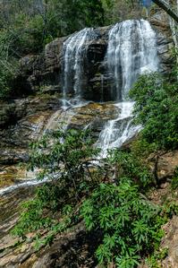
This trail takes the hiker through a pleasant forest of hardwoods and pines to one of the spectacular waterfalls of the Blue Ridge Escarpment. As Overflow Creek plunges over the ledge below one of the East's highest towns, you really get two falls in one. It forms two distinct tiers of falls totaling over 200' in height, each with an entirely different look and feel. Makes for an excellent half-day hike, and it's a great trail for familes and older children.
At A Glance
 1.1 mi round-trip
Difficulty Rating: 2.06 ![]()
Tread Condition: Moderately Rough ![]()
Climb: Climbs Steeply ![]()
Lowest Elevation: 3070 ft
Highest Elevation: 3500 ft
Climb Total: 430 ft
Configuration: Out-and-back
Starting Point: Glen Falls Parking Area
Trails Used: Glen Falls
Hike Start Location
Directions
From the corner of Main Street and NC 106 in Highlands, follow NC 106 West for 1.6 miles. Turn left at the sign for the Glen Falls Scenic Area, then IMMEDIATELY right onto the gravel road. The road crosses a bridge and ends after 1 mile in a small cul-de-sac. Park here.
Details
Hike Description

Begin the trail behind the sign board. A trail leading up Chinquapin Mountain immediately turns right. Stay straight on the Glen Falls trail, which begins level and wide.
You'll come upon a nice overlook off the escarpment on the left. To the right is a fire pit with some sittin' logs. The view is of the Blue Valley, and the foothills and beyond to (on a clear day) the South Carolina Piedmont region.
The trail turns right here, and begins a moderately steep downhill through a mixed forest of medium-aged trees (though some reach fairly impressive sizes). You'll find lots of galax on the ground and plenty of rhododendron and mountain laurel along the way. On its way down, the trail has many steps built in to ease your descent, but with lots of roots, a wet spot or two, and some erosion, the trail is moderately rough overall.
You'll reach a switchback near some cascades above the falls. A side path leads to a small overlook with railing to keep onlookers out of the creek and off the slick rocks. This would be a good idea - you don't want to use these cascades as a waterslide!
The trail pulls away from the creek and you'll reach another split. Turn right to reach the creek again, and another railed overlook at the brink of the main upper falls. Here you get a spectacular view of the water spilling over the sheer rock cliff, as well as the distant mountains and valleys afar. The side path is a bit rougher than the main trail, but very short.

Return to the split, and go straight. The trail travels away from the creek for a short while, around the nose of the ridge, letting you get a through-the-woods view of the next cove East. The trail switches back again to the right, then heads back toward the creek before coming out at the bottom of the upper falls.


The water comes down in two distinct falls; the right side generally has more water. Be careful if you decide to venture very near the falls - the bank is steep and slippery, and the rocks are slippery as well. There is a large flat area great for safe viewing that won't damage you or the fragile environment. In normal or low water flow, it is possible to get out onto the rocks below the falls. But it's not exactly flat, and the creek immediately begins its drop over the second set of falls, so it's not recommended.
The trail makes a left at the falls, which marks the tip of another switchback, and continues down the ridge. You'll wind through another set of short switchbacks before coming out at the base of the lower falls.
You're closer to the creek than at the upper overlook, but the rocks still aren't level. The creek does continue over another, small falls, so be careful here as well if you go out on any rocks. A perfectly safe viewing area is located on the trail at the edge of the creek, so enjoy the view from there.
Though the creek does go over another small falls below the middle tier, it's not as nice as the upper two. Most visitors will be content with seeing the main upper and lower drops, so this hike ends here.
Return to your vehicle on the same path. Remember: it's all uphill, so allow extra time for the return trip!
All Photos from This Hike


Map
Green highlight indicates the route to follow within the trail network for this hike.
Tip: Printing this map? You can pan and zoom the map as desired before printing to show the area you need.
Map Information
Download GPS Data
Click on a route, trail, or point on the map and select the GPS Data tab to download its data.
Data Formats
KML (Google Earth)
KML is the main file type used by Google Earth. If you have Google Earth installed, clicking the KML link should open the trail or point directly in Google Earth for viewing. This is the native file format used by Google Earth, but many other map applications can use and understand KML as well, so if you're not sure which one to download, KML is a good bet.
GPX
The GPX format stands for GPS Exchange - a free, open, XML format for exchanging GPS and map data. GPX is compatible with Google Earth, many other mapping programs, and most GPS devices (such as Garmin). Load the file directly into your GPS to help find your way on your next trip!
GeoJSON
GeoJSON is a newer, lightweight data exchange format which can be used to quickly share map data and may have a smaller size than KML or GPX. Many professional mapping and GIS applications support the GeoJSON format.
About the Map
Copyright
Base Layers
Base layers provided by OpenStreetMap, the US Geological Survey, the US Forest Service, and NC OneMap. Base layer images are subject to the respective copyright policies of their owners. Base layers may not be available at all times due to system maintenance or outages.
WNCOutdoors Base Layer
The WNCOutdoors Base layer is provided by WNCOutdoors.info. It is licensed by Creative Commons Attribution 3.0.
Trail and Marker Overlays
Trail layers and downloadable data are all original works created by WNCOutdoors with guidance from a variety of sources, including ensembles of our own GPS tracks, user contributed GPS tracks, official maps and GIS data from government agencies, and field observations. WNCOutdoors data is made freely available under the Open Database License - you are free to copy and use it for any purpose under the terms of that license (summary).
Tips
- Hover over a trail to see it highlighted. Helps to see start and end points for an individual trail.
- Scroll and zoom the map before printing, and that view will persist into the printed image.
- Click a trail for more details and to download it individually.
Feedback
Ratings
Average Rating: 4.5 (rated 2 times)
Rate It Now:

LEMH said: Does anyone know how busy this hike gets during the summer? I am looking at taking a group of children out to explore the Highlands/Cashiers area and would like to take them on hikes and to see waterfalls in places that may not be too overcrowded during the summer. Any advice would be appreciated!
Gina anderson said: I loved the beautiful waterfalls. Going down was easy but coming back up was steep. We had lots of fun plus the weather was awesome. Thanks
Hiking Diva said: No offense, but this is not a difficult trail at all. Yes, there is a little bit of elevation going back up, but it is well-shaded and even benches for the less-fit ones. Horrible to dissuade people from experiencing it because of some elevation considering how short a hike and how impressive a view. Lots of cool mushrooms, toads, flowers and fungi to note along the way to slow your pace.
Zidi Gleman said: What an awesome hike. Spotted the sign "Glenn Falls 1 mile" from the Hwy 106. U - turned and had a most beautiful afternoon hiking to the bottom and back. Just plain awesome walk. Thank you to all who worked so hard at building and maintaining all those steps. It certainly added to the pleasure of my day. Again thank-you "trail angles" for your efforts. Sincerely - Zidi
Jeannine said: This is a beautiful area. My husband and I had a picnic lunch sitting on a large rock in the middle of the creek down almost a mile on a sunny warm October day. There was a waterfall at our feet, and one to look at when we turned around. It doesn't get any better than that!