Deep Gap Trail

At A Glance


3.8 mi one-way
Difficulty Rating: 3.8 ![]()
Steepness: Hilly ![]()
Tread Condition: Very Rough ![]()
Blaze Color: Orange
Trail Number: 179
Description
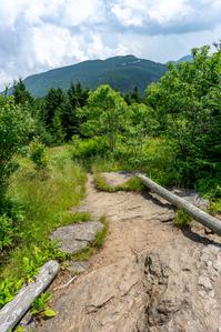
Starting from the picnic area, Deep Gap trail descends to a gap through a dense forest of Fraser fir that have regenerated since the die-off in the 1980's due to Balsam Woolly Adelgid. This is a great place to explore what the native fir forests once looks like, and the trees are approaching maturity (they don't live very long on average). A "fir wave" (line of dying trees due to wind exposure) is approaching the ridge, so it probably won't be long before the views open up again here. Enjoy it now!
The first section of trail is in superb condition as it received a major rehabilitation in the mid-2010's. The trail is a solid gravel-sand surface with massive stone steps to take the hiker over and around any obstacles. Pas the bottom of a long set of descending stairs, the trail reaches the edge of the "fir wave" and amazing views open up to the northwest.
The trail crosses Mt. Craig (2nd highest mountain in the East), Big Tom, Cattail Peak, and Potato Hill (all above 6000 ft) before descending to Deep Gap. Deep gap is a popular National Forest campsite. There are spectacular views in places, with balds on Mt. Craig and dense spruce-fir forests with some mixed high-elevation hardwoods elsewhere. High elevation rugged trail with lots of exposure, with very steep and rough sections. No water along the way.
The Forest Service refers to this trail as the Black Mountains Crest trail once it leaves State Park property. Many people (including official State Park maps) consider it Deep Gap all the way to the gap, but others consider the entire trail - including that within Mt. Mitchell State Park - to be the Black Mountains Crest trail. Whatever you call it, it's the same path. To make an arbitrary decision, we'll draw the dividing line at Deep Gap for now until more of a consensus should arise.
Intersecting Trails
This trail is located in the Mount Mitchell State Park area. For a list of all the trails in that area, see the Mount Mitchell State Park trails list page.
All Photos from the Trail


GPS Map
Map Information
Download GPS Data
Click on a route, trail, or point on the map and select the GPS Data tab to download its data.
Data Formats
KML (Google Earth)
KML is the main file type used by Google Earth. If you have Google Earth installed, clicking the KML link should open the trail or point directly in Google Earth for viewing. This is the native file format used by Google Earth, but many other map applications can use and understand KML as well, so if you're not sure which one to download, KML is a good bet.
GPX
The GPX format stands for GPS Exchange - a free, open, XML format for exchanging GPS and map data. GPX is compatible with Google Earth, many other mapping programs, and most GPS devices (such as Garmin). Load the file directly into your GPS to help find your way on your next trip!
GeoJSON
GeoJSON is a newer, lightweight data exchange format which can be used to quickly share map data and may have a smaller size than KML or GPX. Many professional mapping and GIS applications support the GeoJSON format.
About the Map
Copyright
Base Layers
Base layers provided by OpenStreetMap, the US Geological Survey, the US Forest Service, and NC OneMap. Base layer images are subject to the respective copyright policies of their owners. Base layers may not be available at all times due to system maintenance or outages.
WNCOutdoors Base Layer
The WNCOutdoors Base layer is provided by WNCOutdoors.info. It is licensed by Creative Commons Attribution 3.0.
Trail and Marker Overlays
Trail layers and downloadable data are all original works created by WNCOutdoors with guidance from a variety of sources, including ensembles of our own GPS tracks, user contributed GPS tracks, official maps and GIS data from government agencies, and field observations. WNCOutdoors data is made freely available under the Open Database License - you are free to copy and use it for any purpose under the terms of that license (summary).
Tips
- Hover over a trail to see it highlighted. Helps to see start and end points for an individual trail.
- Scroll and zoom the map before printing, and that view will persist into the printed image.
- Click a trail for more details and to download it individually.
Trail Segments
Trails are often made up of several connecting paths which may have different characteristics, allowed uses, and seasons. This trail is divided into multiple segments as follows:
Deep Gap/Black Mountain Crest - Picnic Area to Mount Craig
- Allowed Uses: Hiking
- Length: 0.77 mi
Deep Gap/Black Mountain Crest - Mount Craig to Big Tom Spur
- Allowed Uses: Hiking
- Length: 0.7 mi
Deep Gap/Black Mountain Crest - Big Tom Spur to State Park Boundary
- Allowed Uses: Hiking
- Length: 0.85 mi
Black Mountain Crest - State Park Boundary to Deep Gap
- Allowed Uses: Hiking
- Length: 1.3 mi
Total Calculated Length: 3.62 mi
This value is derived from our underlying map data, and it may not match officially published information.
Feedback
Ratings
Average Rating: 3.7 (rated 6 times)
Rate It Now:

[Site Admin] Jordan M. said: Hi everyone, We've updated our Trail listings to indicate that all distances are one-way - they're just statistics on a named trail. The Hike distances are for the total hike length (also indicated). We've also updated the one-way Length for this trail to 3.8 mi. That's what our GPS data says and it matches the NC High Peaks Trail Association's calculation. Round-trip would be 7.6 mi. The State Park lists it at 4.3 mi nowadays.
Christopher Baldwin said: I think the distance from the summit of Mount Craig to Deep Gap Campground is only 3.5 miles. At least one comment said 4.5 miles but I think this is wrong. I have ordered a great book on the top 500 hikes in NC and I will be able to verify things for sure. A friend and I are planning to hike March 17 from the base of Mount Mitchell at Black Mountain Campground to the summit of Mount Mitchell to the summits of Mount Craig, Mount Tom, Cattail Peak and Potato Hill and then descend to Deep Gap Campground all as a day hike. If anyone wants to join us, contact me: Christopher Baldwin ChrisBaldwin8@Me.com 704-650-8833
Joe said: My son and I just did this trail 8/10-11, out and back to Deep Gap. My GPS watch (which doesn't like to give me full credit for distances) said only 3.4 mi, while the guy in the gift shop said 3.8, which I thought was supposed to be right. Anyway, perfect weather days, we took 2.5 hrs each day with full packs. He has been working out at a gym, and though I'm a competitive runner, he had me panting the whole trip trying to keep up. Many 1-2 ft steps up/down wears out the legs fast! Definitely need to be sure footed and careful if hauling a pack. I wore hiking boots, though not the $200 variety. We found a camp site in the woods just past Deep Gap - there are many if you look, including some behind rocky areas. Very cool locations, though finding room for a 3-man tent was a bit challenging in the treed sites. We also were able to find water about .4 mi down the "fire road"-to the left once you get to Deep Gap. Look for water dripping down rock faces to the right, from under the tundra. We combined a few small roots to get a good stream of water that filled a 32 oz bag in a minute or so. Be sure to filter. Overall, an excellent, though arduous and exhausting hike. Camp sites are great and the weather was just perfect. Note: there had been bear sightings recently, so be sure to hang your food away from your tent and wrap the rope around the tree trunk as high as possible. Better yet, have a bear canister or odor-proof bags which I had (got mine at REI), though we still hung it.
Donnie said: I am going overnight camping at Deep Gap the first weekend in April, does anyone know if snow is a real possibility at that time of year at that elevation? Thanks
steve said: Gary I just back today from an overnight at Deep Gap. It is 4.3 very tough miles. It rained whole time so made it very slick. I can normally hike 2-3plus miles an hour but this trip took me 4 hours one way. I am in no way an expert hiker but hike a lot and have pretty good lightweight gear. I hate to admit it but this trail smoked me pretty bad. It is though a really nice hike. Hope this helps you. Oh yea might have been just rain related but was extremely windy all night and most all of today...I mean like howling batten down the hatches.
MEade O Bradshaw said: This site needs to let people know if its one way, Round trip or loop. I beleive many people have gotton in a mess because f the lack on info
Gary Pelletier said: We are planning a overnight back pack trip from Mt. Mitchell to a cabin on North fork of Cattail Creek. Camping one night at or near Deep Gap. About Aug, 29 can anyone tell me about his hike? Gary in Denver
Evan said: The 4.5 Mile distance is from The parking lot at Mt. Mitchell Summit one way to Deep Gap Campground. Potato Hill is along this route. It is not the final destination.
Clayton said: Expect rain if camping at Deep Gap. The hike is fun. Very grueling at parts because of strenuous, steep steps and slippery rock faces. Some rocks have ropes tied to allow an easier descent. This route has beautiful views!
Jordan said: I believe the 4.5 mile distance is a one way figure.
Felix said: Is this 4.5 mile hike roundtrip from Mt. Mitchell to Potato hill or just one way?