Big Tom Gap Trail

At A Glance


0.35 mi one-way
Difficulty Rating: 0.35 ![]()
Steepness: Climbs Steeply ![]()
Tread Condition: Very Rough ![]()
Blaze Color: Blue
Trail Number: 191-A
Description
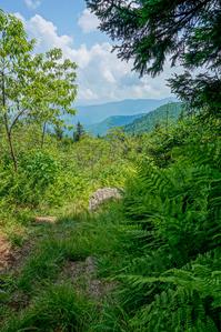
This narrow trail is extremely steep and follows the slope more or less directly uphill. However, it is short. The bottom portion climbs over a rock jumble and the middle section has more of a dirt tread. The trail passes through several openings, and provides good views including Maple Camp Bald to the northeast. It offers loop opportunities with the Buncombe Horse Range Trail, Mount Mitchell Trail and the Black Mountain Crest/Deep Gap trails.
Intersecting Trails
This trail is located in the Mount Mitchell State Park area. For a list of all the trails in that area, see the Mount Mitchell State Park trails list page.
This trail also crosses into these trailhead areas:
All Photos from the Trail


 from Big Tom Trail")

 Trail Sign")

GPS Map
Map Information
Download GPS Data
Click on a route, trail, or point on the map and select the GPS Data tab to download its data.
Data Formats
KML (Google Earth)
KML is the main file type used by Google Earth. If you have Google Earth installed, clicking the KML link should open the trail or point directly in Google Earth for viewing. This is the native file format used by Google Earth, but many other map applications can use and understand KML as well, so if you're not sure which one to download, KML is a good bet.
GPX
The GPX format stands for GPS Exchange - a free, open, XML format for exchanging GPS and map data. GPX is compatible with Google Earth, many other mapping programs, and most GPS devices (such as Garmin). Load the file directly into your GPS to help find your way on your next trip!
GeoJSON
GeoJSON is a newer, lightweight data exchange format which can be used to quickly share map data and may have a smaller size than KML or GPX. Many professional mapping and GIS applications support the GeoJSON format.
About the Map
Copyright
Base Layers
Base layers provided by OpenStreetMap, the US Geological Survey, the US Forest Service, and NC OneMap. Base layer images are subject to the respective copyright policies of their owners. Base layers may not be available at all times due to system maintenance or outages.
WNCOutdoors Base Layer
The WNCOutdoors Base layer is provided by WNCOutdoors.info. It is licensed by Creative Commons Attribution 3.0.
Trail and Marker Overlays
Trail layers and downloadable data are all original works created by WNCOutdoors with guidance from a variety of sources, including ensembles of our own GPS tracks, user contributed GPS tracks, official maps and GIS data from government agencies, and field observations. WNCOutdoors data is made freely available under the Open Database License - you are free to copy and use it for any purpose under the terms of that license (summary).
Tips
- Hover over a trail to see it highlighted. Helps to see start and end points for an individual trail.
- Scroll and zoom the map before printing, and that view will persist into the printed image.
- Click a trail for more details and to download it individually.
Feedback
Ratings
Average Rating: 5.0 (rated 1 times)
Rate It Now:

Parkway Hiker said: This is probably the toughest leg of trail I've ever done in my life. We did the 6-mile loop along the Mt. Mitchell, Buncombe Horse Range, and Black Mountain Crest trails. Highly recommended, but be ready for a serious workout. The Big Tom Gap connector is not really a trail per say, but a rocky runoff, which gives you an idea of the terrain in this area. It's so steep and rugged that the only way up is to follow the runoff. It is, however, well-blazed and easy to follow, but definitely not recommended in wet weather. We had one or two nice views on the way up, along with many breaks, although there isn't much room to lounge around on this trail. As we approached the top of the ridge and the Black Mountain Crest trail, the weather changed abruptly from sunny and warm to foggy and cold, which was actually welcome after sweating it out on the way up. The rest of this loop is no walk in the park, either, but this particular 0.4 mile section will kick your ass in a very memorable way. I'll be back.