Cove Creek and Caney Bottom Hike

Beautiful Pisgah scenery abounds on this classic loop hike, which travels past several nice waterfalls, through some flats above the Davidson River valley, and around seepage bogs and open, fern-filled woods. It's moderate overall; some of the initial climbs are steep, but short, with some short sections of rougher trail.
At A Glance
 4.2 mi round-trip
Difficulty Rating: 5.75 ![]()
Tread Condition: Moderately Rough ![]()
Climb: Climbs Moderately ![]()
Lowest Elevation: 2560 ft
Highest Elevation: 3050 ft
Climb Total: 500 ft
Configuration: Loop with out and back extension
Starting Point: Access Road for Cove Creek Group Camp on FR 475, near the Pisgah Fish Hatchery.
Trails Used: Caney Bottom, Cove Creek, Cove Creek Falls
Hike Start Location
Directions
From Asheville, take I-240 west to I-26 east to exit 40, NC Hwy. 280/Asheville Airport. Turn right onto NC 280; follow this 4-lane highway for 16 miles toward Brevard. At the intersection with US highways 276 and 64, turn right onto US 276 west. Proceed on US 276 for 5.2 miles. Turn left on FS 475, following signs for the Pisgah Center for Wildlife Education and Fish Hatchery. You'll pass the fish hatchery on the left after 1.4 miles. Drive 1.8 miles past the fish hatchery to where the pavement ends (at the road to Cove Creek Group Campground just before a small bridge) There is a parking area on the left; park there.
Details
Hike Description
Begin the hike on the road leading uphill along the creek in a general northerly direction. Your first main destination will be Cove Creek Falls. There is more than one way to get to the waterfall, which I'll describe below.
Both routes begin on the gravel road behind the gate; there is a large sign board on the right. The road fords the creek after 500 feet or so; follow the trail to the right which leads to a nice footbridge, then joins back with the road. Continue up the road; the hike along this section is pleasant. The creek will now be to the east and you will pass several small cascades with potholes in the rock. The road climbs gently toward the group camping area.

Unfortunately, you will see many dead Eastern Hemlock trees along this road, as you will along most of this hike. As of January 2014, almost all of them were dead. They were once a defining characteristic of this cove; now, something else will have to slowly take their place.
Heading straight up the creek to the falls is both the easiest and the simplest way to get there, and puts you at the better (east) side viewing area. But it does take you through the group campground, which you might want to avoid if it's occupied. So I'll describe two different ways to reach the falls from here, one which goes up the east side and the other which goes up the west side of the creek. You might want to look at the map below to see what I mean here.
Option 1: Straight to the Falls
The Caney Bottom trail will exit the road uphill to your left, just before the first big clearing for the group camp. Do not take this trail yet, just go straight. Pass through the large clearing for the first group camp. The road will enter the woods near a pit toilet on the other side of the clearing. To the right of that is a small "sliding rock" with a nice pool at the bottom. This makes a popular place to cool off during the summer, and, yes, people do use the bumpy rock as a waterslide!
The road will reach another ford of Cove Creek a short distance beyond the first clearing. Go left on the path close to the creek where you'll find another footbridge. Join the road again; you'll then enter the second group camping area in another large clearing. The gravel road ends in the clearing; bear left toward the pit toilet building to stay near the creek. A trail starts upstream along the east side of the creek at the north end of the clearing by the pit toilets; take that.

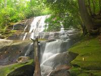
Now you'll just follow this path upstream on the east side of the creek all the way to Cove Creek Falls, even though its name will change a couple of times. The blue-blazed Caney Bottom trail joins in two different places, first coming in from the left at a log bridge and then exiting up the hill to the right. Just keep going straight up the east side of the creek. After the Caney Bottom trail exits to the right, the unofficial but easy to follow path continues upstream on an old roadbed. It soon starts climbing more substantially, going up and down some just before reaching the falls, about 850 feet past the Caney Bottom trail bridge. The viewing area on this side of the creek is vastly better than on the west side where most people unfortunately wind up.
Option 2: Via Caney Bottom Trail
To bypass the group camping area, take the Caney Bottom trail where it exits the road on the left. This winds its way uphill on the slopes above the campground, dipping into some small coves and going around the nose of a ridge on an old road bed. You'll reach a junction with the Cove Creek trail which continues straight up the old road bed. Caney Bottom trail drops off the road to the right.
(This is where many guides will tell you to turn and take an unofficial trail up the west side of Cove Creek to reach the falls; don't do that because that trail is crappy. #1 it's muddy, #2 it's more steep, #3 it's eroded, and #4 foot traffic is impacting the critical habitats of some small seeps and tributaries that join the main creek on that side. Bad.)
Continue straight onto the Cove Creek trail.
After a couple more small cove traverses and a short climb, you'll hear the waterfall below you on the right. Keep going. An official, signed spur trail to the falls will appear a short distance above the top of the falls on the right. Take that spur path, which switchbacks down to the crappy trail no one should be using, then reaches the falls on the west (wrong) side from the viewing area. Cross the creek to the east side for the best view.
It may be a tricky crossing if you want dry feet. The water is usually shallow above the large rocks, and there are big logs to step on, but use caution since there is a small boulder drop just downstream from the pool under the logs.
Beyond the Falls
Regardless of how you get there, after you're done enjoying the falls, there's more to enjoy on this hike! Cross the creek back to the west side and take the official trail back uphill.
It will pass below a rock outcrop an climb up to the intersection with the crappy trail on the left. Turn right to stay on the official trail. This takes you up to a point near the top of the falls and it's somewhat steep. It's short, though - my 4 year old had no problem negotiating it while holding my hand. The path splits; take either fork uphill. They both go to the same place after 100 feet or so. When you reach the junction with the yellow-blazed Cove Creek trail, turn right, north, uphill.

The Cove Creek trail is wide, on an old logging road bed, and easy to follow. It's not nearly as steep or rough as some of the unofficial paths back near Cove Creek Falls - in fact, the roughest part of the hike is now behind you. The trail does climb gently, through a varied forest of mixed hardwoods and (formerly) hemlocks along tributary creeks.
There weree a couple of rotting log bridges list time I hiked here - another aspect of this area the Forest Service needs to look at closely. Near the top of the climb, a longer, nicer wooden bridge crosses the main stem of the creek.
Just past the bridge, the trail climbs some steps and bears right; it is well-signed and blazed. Sections of trail in this area have been re-worked recently. In one area, the erosion gulley which used to be the road is so deep, the trail was re-located onto a bench cut into the side of the gulley itself! At least this does keep the trail tread out of the bottom of the gulley and out of the mud.
The character of the land changes as you approach the upper end of the loop as well. There are flats and a large forest opening to the left of the trail at one point. It's almost flat enough to be considered a small plateau, and this area lets the streams gather enough water before dropping into the Davidson River valley and forming their waterfalls.
You'll reach another log bridge, the trail will turn right, and then you'll reach a trail intersection. The Cove Creek trail goes left and intersects gravel road FS 225B in about 1/2 mile. The trail you want is straight ahead, and it's the Caney Bottom trail. This marks the highest point on the hike - it's all downhill from here.
The Caney Bottom trail is not open to bicycles, although mountain bikers have been known to poach the trail from time to time. It's a bad idea if they don't want ALL the trails in this area closed to bikes. You might remind them of that if you see someone riding here!
The Caney Bottom trail does follow some old logging roads in places, but it's mostly custom-built tread. Its character is much different from the Cove creek trail - it's a bit rougher, but never very difficult. The trail generally follows the creek downstream. The upper part of the creek is slow and lazy, and some small bogs contribute trickles of clean mountain water into the main stream. Parts of the trail near the creek are thickly hemmed in with dog hobble and moist, mossy logs lie everywhere.
As you head downstream, the creek suddenly drops over a small series of falls and cascades to your left. It's difficult to get a closer view of this first set of falls by leaving the trail. If you do try, be careful - the banks are steep, easily eroded and covered with fragile vegetation (as well as some not-so-fragile but frustrating thickets of rhododendron). The first falls is not the nicest, anyway.

The creek levels out, and the trail descends to catch up with it before the water drops over a larger, more significant falls. This one is easily visible from the trail but almost impossible to get to the base of. Just beyond the falls, the trail travels through an open section of woods with the ground carpeted in ferns. The trail catches up with the creek one final time, before it drops into another set of cascades. This last series of falls is smaller than the one above, and it lies between huge boulders in a very wet, dank cove.
This third distinct set of cascades marks the last on this hike, and the trail will begin a slight uphill climb as it wraps around the end of the ridge between this and Cove Creek. The trail will intersect with a couple of different trails leading out of the group camping area; you can bear left on either of them and pick up the gravel road you came in on, or stay straight on the Caney Bottom trail (which makes a slight climb to a left turn and then comes out on the gravel road) to return to the parking area.
All Photos from This Hike


Map
Green highlight indicates the route to follow within the trail network for this hike.
Tip: Printing this map? You can pan and zoom the map as desired before printing to show the area you need.
Map Information
Download GPS Data
Click on a route, trail, or point on the map and select the GPS Data tab to download its data.
Data Formats
KML (Google Earth)
KML is the main file type used by Google Earth. If you have Google Earth installed, clicking the KML link should open the trail or point directly in Google Earth for viewing. This is the native file format used by Google Earth, but many other map applications can use and understand KML as well, so if you're not sure which one to download, KML is a good bet.
GPX
The GPX format stands for GPS Exchange - a free, open, XML format for exchanging GPS and map data. GPX is compatible with Google Earth, many other mapping programs, and most GPS devices (such as Garmin). Load the file directly into your GPS to help find your way on your next trip!
GeoJSON
GeoJSON is a newer, lightweight data exchange format which can be used to quickly share map data and may have a smaller size than KML or GPX. Many professional mapping and GIS applications support the GeoJSON format.
About the Map
Copyright
Base Layers
Base layers provided by OpenStreetMap, the US Geological Survey, the US Forest Service, and NC OneMap. Base layer images are subject to the respective copyright policies of their owners. Base layers may not be available at all times due to system maintenance or outages.
WNCOutdoors Base Layer
The WNCOutdoors Base layer is provided by WNCOutdoors.info. It is licensed by Creative Commons Attribution 3.0.
Trail and Marker Overlays
Trail layers and downloadable data are all original works created by WNCOutdoors with guidance from a variety of sources, including ensembles of our own GPS tracks, user contributed GPS tracks, official maps and GIS data from government agencies, and field observations. WNCOutdoors data is made freely available under the Open Database License - you are free to copy and use it for any purpose under the terms of that license (summary).
Tips
- Hover over a trail to see it highlighted. Helps to see start and end points for an individual trail.
- Scroll and zoom the map before printing, and that view will persist into the printed image.
- Click a trail for more details and to download it individually.
Feedback
Ratings
Average Rating: 5.0 (rated 2 times)
Rate It Now:

Kim & Glen, Intrepid Trippers said: The map above does not include the roads (ie 275B). Where is the distance & other info about the complete yellow blaze trail, the Cove Creek trail ending at 275B - not Caney Bottom. Looks like Caney Bottom was part of the loop we missed (which we were told to avoid in the Waterfall guide!!!) We are new hikers. All is good. Proud of our accomplishment. Definitely a 5 star adventure for us!!!
Kim & Glen, Intrepid Trippers said: We planned to hike 4.5 mi Cove Creek Loop. Although we had 2 Pisgah National Park maps & "Great Waterfalls of NC" guide book, since trails were unnamed & directions confusing on maps, we followed the yellow blaze trail, thinking it was the loop. NOT. It ended at 275B, a gravel road with NO signs. Fortunately, we decided to retrace our steps back to Cove Creek Group Campground, for a roundtrip of 10+ mile hike!!! It was gorgeous, the falls were all ours for 30 min, as was most of the trail. BUT we need better DETAILED maps!!! Any suggestions!!!
Shannon said: We did this hike this weekend with four kids, ages 8-12. We followed the directions exactly and had a great time. It took us 2 hours and 20 minutes, with one stop for lunch. You don't need sunscreen, but you definitely want bug spray!
[Site Admin] Jordan M. said: Hmm...I wonder if we're talking about the same trails, then. I'd have to agree that sticking to the the *official* trails to the falls - left on Caney Bottom from the road, straight on Cove Creek, then right at the sign for the falls - would be the *best* way to visit the falls. And you wouldn't have to cross the creek at all, as you said. But that's not the way most guides recommend! There are two "goat trails" leading up the creek - one on each side - and the one on the left is much worse. It's what most guides recommend: left on Caney Bottom from the road, *right* on Caney Bottom where it meets Cove Creek, and then left on the "crappy" goat path before the bridge. So, my opinion is that if you're going to use one of the goat paths and cross the creek twice - which most people will end up doing to get a better view - best to use the right path. But I do agree that less experienced hikers, or those with small children, should stick to the official trails and just peek around the boulder for a view of the falls.
Cas Godwin said: Enjoyed the hike 4/27/14, but we didn't find the "crappy" part of the trail to be crappy at all. Your suggested trail (straight on up at the left-turning bridge) was pretty much a goat path that some goats would probably refuse. And although it may be true most people taking the "crappy" trail may cross the creek twice at the waterfall, truth is, you could avoid crossing it at all via the crappy way. Your suggested way left no choice but to cross. Nice description, great trail, and we'll be back, but I'd suggest first-timers on that trail to take the "standard" route, with the falls as a short side trip.
Don Ross said: These directions were excellent and I really enjoyed the hike, especially the falls. Thanks for posting it.