Buncombe Horse Range Trail

At A Glance


18.5 mi one-way
Difficulty Rating: 27.16 ![]()
Steepness: Climbs Moderately ![]()
Tread Condition: Moderately Rough ![]()
Lowest Elevation: 2840 ft
Highest Elevation: 5850 ft
Climb Total: 3200 ft
Blaze Color: White Diamond
Trail Number: 191
Hikes That Use This Trail: Mount Mitchell
Description
This is the third-longest trail in the Appalachian District, after the Appalachian Trail and Mountains to Sea Trail. It also has one of the highest average elevations of any trail in the region, with a long stretch above 5000 ft topping out at about 5800 ft on Commissary Ridge.
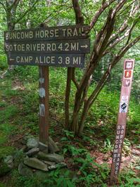
Starting on the south end at FS 472, S. Toe River Road, the trail climbs 1800 ft up its namesake ridge through Salt Rock Gap to the junction with the old railroad grade/Mountains to Sea Trail near the headwaters of Right Prong. It passes through beautiful enchanted red spruce groves along this stretch.
The trail then turns north onto the old railroad grade and, in addition to open areas with grasses, mountain laurel, rhododendron, and blueberry shrubs, runs through stands of non-native Norway spruce as well as red spruce and Fraser fir, with views of above-6,000 ft peaks. Good camping spots are found near Commissary Hill and Maple Camp Bald, just outside Mount Mitchell State Park, where there are a few (signed) junctions.
It continues north of the point where the Mount Mitchell/Mountains to Sea trail leaves the shared path (to descend to Black Mountains Campground), on a lesser-used portion of the old railroad grade, before beginning its long descent of Maple Camp Ridge to Colbert Creek. Note that the trail switchbacks heavily below Maple Camp Bald and pay close attention to the trail signs and blazes because the trail crosses open fields and many intersections.
Intersecting Trails
This trail is located in the Black Mountains & Toe River area. For a list of all the trails in that area, see the Black Mountains & Toe River trails list page.
This trail also crosses into these trailhead areas:
All Photos from the Trail


GPS Map
Map Information
Download GPS Data
Click on a route, trail, or point on the map and select the GPS Data tab to download its data.
Data Formats
KML (Google Earth)
KML is the main file type used by Google Earth. If you have Google Earth installed, clicking the KML link should open the trail or point directly in Google Earth for viewing. This is the native file format used by Google Earth, but many other map applications can use and understand KML as well, so if you're not sure which one to download, KML is a good bet.
GPX
The GPX format stands for GPS Exchange - a free, open, XML format for exchanging GPS and map data. GPX is compatible with Google Earth, many other mapping programs, and most GPS devices (such as Garmin). Load the file directly into your GPS to help find your way on your next trip!
GeoJSON
GeoJSON is a newer, lightweight data exchange format which can be used to quickly share map data and may have a smaller size than KML or GPX. Many professional mapping and GIS applications support the GeoJSON format.
About the Map
Copyright
Base Layers
Base layers provided by OpenStreetMap, the US Geological Survey, the US Forest Service, and NC OneMap. Base layer images are subject to the respective copyright policies of their owners. Base layers may not be available at all times due to system maintenance or outages.
WNCOutdoors Base Layer
The WNCOutdoors Base layer is provided by WNCOutdoors.info. It is licensed by Creative Commons Attribution 3.0.
Trail and Marker Overlays
Trail layers and downloadable data are all original works created by WNCOutdoors with guidance from a variety of sources, including ensembles of our own GPS tracks, user contributed GPS tracks, official maps and GIS data from government agencies, and field observations. WNCOutdoors data is made freely available under the Open Database License - you are free to copy and use it for any purpose under the terms of that license (summary).
Tips
- Hover over a trail to see it highlighted. Helps to see start and end points for an individual trail.
- Scroll and zoom the map before printing, and that view will persist into the printed image.
- Click a trail for more details and to download it individually.
Trail Segments
Trails are often made up of several connecting paths which may have different characteristics, allowed uses, and seasons. This trail is divided into multiple segments as follows:
FS 472 to Mountains to Sea Trail at NC 128
- Allowed Uses: Hiking, Horseback Riding
- Length: 4.58 mi
Mountains to Sea Trail at NC 128 to Camp Alice
- Allowed Uses: Hiking, Horseback Riding
- Length: 3.27 mi
Camp Alice to Commissary Campsite & Mount Mitchell Trail
- Allowed Uses: Hiking, Horseback Riding
- Length: 0.54 mi
Commissary Campsite to Mountains to Sea and Mount Mitchell Trail
- Allowed Uses: Hiking, Horseback Riding
- Length: 320 ft
Mountains to Sea and Mount Mitchell Trail to Maple Camp Bald
- Allowed Uses: Hiking, Horseback Riding
- Length: 8.54 mi
Total Calculated Length: 16.98 mi
This value is derived from our underlying map data, and it may not match officially published information.
Feedback
Ratings
Average Rating: (rated 0 times)
Rate It Now:

No comments yet.