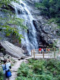
Hickory Nut Falls Hike

This moderate hike takes you out-and-back through a vibrant forest to the base of Hickory Nut Falls. This is a very high and neat waterfall. You'll travel along the base of the cliffs that form the edge of the Hickory Nut Gorge and the Falls. Trees along this trail are large and interpretive signs help you identify points of interest in the geography and the ecology. At the base of Hickory Nut Falls, enjoy a splash of cold mountain water on a hot day - or just relax in the beauty of one of the highest waterfalls in the East!
At A Glance
 1.5 mi round-trip
Difficulty Rating: 2 ![]()
Tread Condition: Some Obstacles ![]()
Climb: Climbs Gently ![]()
Lowest Elevation: 1760 ft
Highest Elevation: 1900 ft
Climb Total: 200 ft
Configuration: Out-and-back
Starting Point: Lower parking area at Chimney Rock Park
Trails Used: Hickory Nut Falls
Hike Start Location
Directions
From Asheville, take I-240 East to US 74-A. Follow US 74-A to the Chimney Rock Park entrance gate and pay the entrance fee (more information about the entrance fee). Park in either of the top parking lots - the well-signed trail starts at the lower of the two.
Details
Hike Description
Note: There is a fee to enter Chimney Rock Park. Get more information on the park's web site.
Hickory Nut Falls is not only one of the tallest waterfalls in the region, but it was arguably made more notable by its appearance in the movie The Last of the Mohicans. Formerly called the "Forest Stroll" trail, the path leading to its base has been more aptly named the Hickory Nut Falls trail since the park came under state ownership. And that's good, since the waterfall is the trail's main destination - and one of the top destinations in the park!

That's not to say Forest Stroll was a totally inappropriate moniker, though, since that's what the hike to the falls entails. You'll enjoy walking through the mixed hardwood forest along almost the entire route.
Shortly after heading under the entrance sign and gate, you'll reach the intersection with the Outcroppings trail on the left, which takes the form of a sturdy, elaborate set of stairs (newly reconstructed in 2012). That "trail" goes up toward the main parking area and the Chimney. Keep straight on the Hickory Nut Falls trail.
Next you'll reach the Four Seasons trail which descends a set of steps on the right. As its name indicates, the trail is open all year long and can be used as a longer route to get to Hickory Nut Falls from the Meadows area. Keep straight again here.
Passing through the next gate puts you solidly on the path to the base of the falls. There are no other intersections beyond the second gate.
Although the trail is not difficult, there are a couple of moderate climbs and at times the surface is quite rocky. Signs along the route explain various points of interest and depict the ecology of the environment through which you are traveling. Various plants are introduced and aspects of the geography are discussed, and there are plenty of wildflowers to be found, admired, and photographed (but not picked!) during the growing season.

One sign depicts a deep erosion gully as a natural factor in the shaping of this mountain. In general, it's true that erosion has resulted in nearly all of the topography we see today in the southern Appalachians. At the gully in question, however, it appears that when the old road which now forms this trail was cut in, it greatly exacerbated the rate of erosion on the uphill side, making this particular gully a somewhat man-made phenomenon. Nevertheless, this is an interesting spot with the deep, rocky ravine reaching right up to the base of the sheer rock cliffs looming above you.
You can see plenty more evidence of how erosion factors into the creation of the surrounding topography. During a heavy rainstorm some years back, a major section of the trail slid away and a huge, beefy bridge was built to replace it. The bridge is sturdy and wide and can easily carry a loaded pickup truck. Just beyond the bridge, you'll round a small ridge, where you'll be near the base of the falls and begin to hear them.
The trail ends in a paved area with a picnic table, and a narrower path heads left up a set of steps to a viewing area at the base of the falls. It is relatively safe to rock-hop and explore the stream right at the base of the falls since it is flat there, but it is generally frowned upon and signs will admonish your decision if you do that. So stay very close to the base of the falls, since the stream has more tall cascades below the small flat area.
Once you're done exploring and marveling at the falls and huge cliff walls, return to your vehicle on the same path.
All Photos from This Hike


Map
Green highlight indicates the route to follow within the trail network for this hike.
Tip: Printing this map? You can pan and zoom the map as desired before printing to show the area you need.
Map Information
Download GPS Data
Click on a route, trail, or point on the map and select the GPS Data tab to download its data.
Data Formats
KML (Google Earth)
KML is the main file type used by Google Earth. If you have Google Earth installed, clicking the KML link should open the trail or point directly in Google Earth for viewing. This is the native file format used by Google Earth, but many other map applications can use and understand KML as well, so if you're not sure which one to download, KML is a good bet.
GPX
The GPX format stands for GPS Exchange - a free, open, XML format for exchanging GPS and map data. GPX is compatible with Google Earth, many other mapping programs, and most GPS devices (such as Garmin). Load the file directly into your GPS to help find your way on your next trip!
GeoJSON
GeoJSON is a newer, lightweight data exchange format which can be used to quickly share map data and may have a smaller size than KML or GPX. Many professional mapping and GIS applications support the GeoJSON format.
About the Map
Copyright
Base Layers
Base layers provided by OpenStreetMap, the US Geological Survey, the US Forest Service, and NC OneMap. Base layer images are subject to the respective copyright policies of their owners. Base layers may not be available at all times due to system maintenance or outages.
WNCOutdoors Base Layer
The WNCOutdoors Base layer is provided by WNCOutdoors.info. It is licensed by Creative Commons Attribution 3.0.
Trail and Marker Overlays
Trail layers and downloadable data are all original works created by WNCOutdoors with guidance from a variety of sources, including ensembles of our own GPS tracks, user contributed GPS tracks, official maps and GIS data from government agencies, and field observations. WNCOutdoors data is made freely available under the Open Database License - you are free to copy and use it for any purpose under the terms of that license (summary).
Tips
- Hover over a trail to see it highlighted. Helps to see start and end points for an individual trail.
- Scroll and zoom the map before printing, and that view will persist into the printed image.
- Click a trail for more details and to download it individually.
Feedback
Ratings
Average Rating: 3.3 (rated 45 times)
Rate It Now:

No comments yet.