Douglas Falls Trail

At A Glance


2.7 mi one-way
Difficulty Rating: 5.48 ![]()
Steepness: Climbs Steeply ![]()
Tread Condition: Moderately Rough ![]()
Lowest Elevation: 4190 ft
Highest Elevation: 5300 ft
Climb Total: 1290 ft
Blaze Color: White
Trail Number: 162
Hikes That Use This Trail: Douglas Falls (Lower Approach)
Description
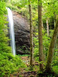
From FS 74, the trail begins as an easy, 0.5 mile route to its spectacular eponymous waterfall - a great family hike. There are a few tricky sections (including one where a fallen tree has exposed some slick bedrock), but overall the route is in fairly good shape. The trail passes through a virgin forest, including a former hemlock grove containing (formerly) very large trees, before coming out on the stream below the falls. It's possible to cross the stream and walk into the grotto behind the falls for a neat view out into the forest. This is the Douglas Falls - Lower Approach Hike.
Most people stop at the falls, but if you're continuing up to the Mountains to Sea Trail, look for where the trail veers left up a set of rock steps just before reaching the falls. From there, it meanders uphill to a large boulder sitting below the cliff band, overlooking the falls. It then continues uphill along the cliff band, wraps around the end of that, and continues its climb in the stream valley above the falls. The trail passes through the Craggy Wilderness Study Area and the environment from here up to the Mountains to Sea Trail is remote and pristine, though the trail is blazed.
You'll wrap into the next cove south and pass The Cascades, another high waterfall that's difficult to see in the summer and during low water flow. The trail moves into rich, old-growth northern hardwood forests blanketed in mosses and ferns as it climbs including some enormous old hemlocks (which, sadly, are all now dead). The trail climbs through a series of switchbacks as it nears the terminus at the Mountains to Sea Trail.
Turning right (south) on the Mountains to Sea Trail leads to the Parkway and the Craggy Gardens Visitor Center. Those wishing to access to the falls on a much more difficult, rugged, and steep hike than from the lower parking area can start at the visitor center, hike down to the falls, and back out again for a round-trip of about 7 miles. This is the Douglas Falls - Upper Approach Hike.
Intersecting Trails
This trail is located in the Big Ivy (Coleman Boundary) area. For a list of all the trails in that area, see the Big Ivy (Coleman Boundary) trails list page.
All Photos from the Trail


GPS Map
Map Information
Download GPS Data
Click on a route, trail, or point on the map and select the GPS Data tab to download its data.
Data Formats
KML (Google Earth)
KML is the main file type used by Google Earth. If you have Google Earth installed, clicking the KML link should open the trail or point directly in Google Earth for viewing. This is the native file format used by Google Earth, but many other map applications can use and understand KML as well, so if you're not sure which one to download, KML is a good bet.
GPX
The GPX format stands for GPS Exchange - a free, open, XML format for exchanging GPS and map data. GPX is compatible with Google Earth, many other mapping programs, and most GPS devices (such as Garmin). Load the file directly into your GPS to help find your way on your next trip!
GeoJSON
GeoJSON is a newer, lightweight data exchange format which can be used to quickly share map data and may have a smaller size than KML or GPX. Many professional mapping and GIS applications support the GeoJSON format.
About the Map
Copyright
Base Layers
Base layers provided by OpenStreetMap, the US Geological Survey, the US Forest Service, and NC OneMap. Base layer images are subject to the respective copyright policies of their owners. Base layers may not be available at all times due to system maintenance or outages.
WNCOutdoors Base Layer
The WNCOutdoors Base layer is provided by WNCOutdoors.info. It is licensed by Creative Commons Attribution 3.0.
Trail and Marker Overlays
Trail layers and downloadable data are all original works created by WNCOutdoors with guidance from a variety of sources, including ensembles of our own GPS tracks, user contributed GPS tracks, official maps and GIS data from government agencies, and field observations. WNCOutdoors data is made freely available under the Open Database License - you are free to copy and use it for any purpose under the terms of that license (summary).
Tips
- Hover over a trail to see it highlighted. Helps to see start and end points for an individual trail.
- Scroll and zoom the map before printing, and that view will persist into the printed image.
- Click a trail for more details and to download it individually.
Trail Segments
Trails are often made up of several connecting paths which may have different characteristics, allowed uses, and seasons. This trail is divided into multiple segments as follows:
Falls to Mountains to Sea Trail
- Allowed Uses: Hiking
- Length: 2.17 mi
Lower Parking Area to Falls
- Allowed Uses: Hiking
- Length: 0.53 mi
Total Calculated Length: 2.7 mi
This value is derived from our underlying map data, and it may not match officially published information.
Feedback
Ratings
Average Rating: (rated 0 times)
Rate It Now:

Robert Singleton said: I have been to the lower falls several times, but was unable to find the trail that leads up to the Mountain-to-Sea trail. I would appreciate any directions.