Perkins Trail

At A Glance


1.44 mi one-way
Difficulty Rating: 2.93 ![]()
Steepness: Climbs Steeply ![]()
Tread Condition: Moderately Rough ![]()
Lowest Elevation: 3810 ft
Highest Elevation: 4500 ft
Climb Total: 690 ft
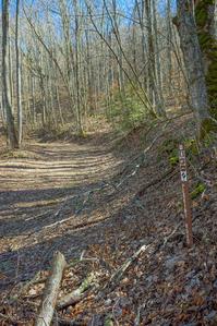
Blaze Color: Orange
Trail Number: 175
Description
Also known as Perkins Road. Climbs steeply on an old road bed from FS 74 to the Laurel Gap trail. Starts in a fairly nondescript cove hardwood forest setting but quickly reaches some areas with very large, impressive trees as it winds its way up into the Walker Branch cove. As it rounds the nose of the ridge, descends slightly to cross Walker Branch at a confluence of its two main upper forks. This is a neat spot with big bluffs overlooking the creek and the water tumbling into a deep gorge-like setting below.
Beyond the first crossing, the trail becomes covered with cobblestones and it makes a 2nd crossing back to river left in short order. The forest changes, with more northern hardwood species, a few Red Spruce struggling to reach for sunlight beneath the hardwoods, and even a few surviving hemlocks. The trail parallels the stream for a short distance, before turning right, south, for the final connection up to the Laurel Gap trail.
Intersecting Trails
This trail is located in the Big Ivy (Coleman Boundary) area. For a list of all the trails in that area, see the Big Ivy (Coleman Boundary) trails list page.
All Photos from the Trail


GPS Map
Map Information
Download GPS Data
Click on a route, trail, or point on the map and select the GPS Data tab to download its data.
Data Formats
KML (Google Earth)
KML is the main file type used by Google Earth. If you have Google Earth installed, clicking the KML link should open the trail or point directly in Google Earth for viewing. This is the native file format used by Google Earth, but many other map applications can use and understand KML as well, so if you're not sure which one to download, KML is a good bet.
GPX
The GPX format stands for GPS Exchange - a free, open, XML format for exchanging GPS and map data. GPX is compatible with Google Earth, many other mapping programs, and most GPS devices (such as Garmin). Load the file directly into your GPS to help find your way on your next trip!
GeoJSON
GeoJSON is a newer, lightweight data exchange format which can be used to quickly share map data and may have a smaller size than KML or GPX. Many professional mapping and GIS applications support the GeoJSON format.
About the Map
Copyright
Base Layers
Base layers provided by OpenStreetMap, the US Geological Survey, the US Forest Service, and NC OneMap. Base layer images are subject to the respective copyright policies of their owners. Base layers may not be available at all times due to system maintenance or outages.
WNCOutdoors Base Layer
The WNCOutdoors Base layer is provided by WNCOutdoors.info. It is licensed by Creative Commons Attribution 3.0.
Trail and Marker Overlays
Trail layers and downloadable data are all original works created by WNCOutdoors with guidance from a variety of sources, including ensembles of our own GPS tracks, user contributed GPS tracks, official maps and GIS data from government agencies, and field observations. WNCOutdoors data is made freely available under the Open Database License - you are free to copy and use it for any purpose under the terms of that license (summary).
Tips
- Hover over a trail to see it highlighted. Helps to see start and end points for an individual trail.
- Scroll and zoom the map before printing, and that view will persist into the printed image.
- Click a trail for more details and to download it individually.
Feedback
Ratings
Average Rating: 4.0 (rated 1 times)
Rate It Now:

susan said: All said, of Douglas Falls, Bear Pen, Elk Pen and Perkins, tie between Bear Pen and Perkins at this time (and time of year) . Not outstanding in any way EXCEPT the Walker Creek crossing made a terrific spectacle. Neat coulee where 2 forks converge. Massive rock on south side, stand on top of falls. At very top of trail some long views possible. Tread biked out mud toughs for a bit of upper 1/4. Most steep happens along creek section over cobbly rocks. Much water on them when I was there. I like a real trail: various tread, a tad of challenge, a 'special event' - so this rates. 5/30 4 -8p