Trails in the Blue Ridge Parkway Section 2 Trailhead Area

Here is a list of all trails in the Blue Ridge Parkway Section 2 Trailhead area.

Each trail has its own printable page with all the information and links, including (where available):

  • directions to the starting point
  • difficulty
  • length
  • elevation change
  • a map
  • photos from along the way, and
  • a detailed description and trail directions.

For general information about the Blue Ridge Parkway Section 2 trailhead, see the Blue Ridge Parkway Section 2 Trailhead page.

Need to find trails by another method? Go back to Trails.

Bass Lake Trail

Easy
  • Open to carriages, horses, and hikers.
  • 1.7mi, ,

Beacon Heights Trail

Moderate
  • 0.22mi, ,

Black Bottom Trail

Easy
  • Open to carriages, hikers and horses.
  • 0.5mi, ,

Boone Fork Trail

Moderate
  • 4.9mi, ,

Cascades Trail

Moderate
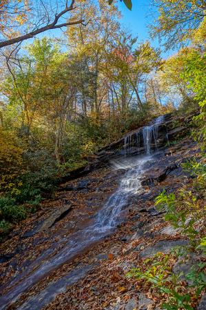
  • Travels through a mixed cove/northern hardwood forest to the Cascades, a high, sliding waterfall that drains the Blue Ridge. Interpretive signs. Gravel surface in places; steeper & rougher near the Cascades.
  • 0.5mi, ,

Cold Prong Pond Loop Trail

Easy
  • This is a short, easy loop around what either used to be or only sometimes is a pond. Whether or not a pond exists, there is definitely a grassy, weedy opening in the forest with a small stream flowing out of one side. The loop is nearly level with...
  • 0.3mi, Climbs Gently, Few Obstacles

Deer Park Trail

Moderate
  • Open to carriages, horses, and hikers.
  • 0.8mi, ,

Duncan Trail

Moderate
  • Open to carriages, horses and hikers.
  • 2.5mi, ,

Figure Eight Trail

Easy
  • 0.7mi, ,

Flat Top Mountain Trail

Moderate
  • Open to carriages, horses and hikers.
  • 3mi, ,

Linn Cove Viaduct Access Trail

Easy
  • This easy, paved path provides access to the underside of the Linn Cove Viaduct, an engineering marvel of the Blue Ridge Parkway. This structure was built from the top down, allowing the fragile environment beneath it to be relatively undisturbed....
  • 0.15mi, ,

Maze Trail

Moderate
  • Open to carriages, horses, and hikers.
  • 2.3mi, ,

Mountains to Sea Section 5 Trail

Most Difficult
  • **Beacon Heights to Devil's Garden Overlook** Beacon Heights, BRP mp 305.3 (near Grandfather Mountain) to Blowing Rock (US-321) BRP mp 291.9. Among the co-signed trails followed by the Mountains to Sea Trail on this stretch is the exceptionally...
  • 90.3mi, Hilly, Moderately Rough

Price Lake Loop Trail

Moderate
  • 2.3mi, ,

Rich Mountain Trail

Moderate
  • Open to carriages, horses, and hikers.
  • 3mi, ,

Rock Creek Bridge Trail

Easy
  • Open to carriages, horses, and hikers.
  • 1mi, ,

Tanawha Trail

Moderate
  • This excellent trail, completed in 1993, follows the contours of Grandfather Mountain above the Blue Ridge Parkway. It travels through interesting and diverse geology and forest environments, including northern hardwood forests and spruce-fir...
  • 13.5mi, Hilly, Moderately Rough

The Lump Trail

Easy
  • This easy trail travels up "the lump", a cleared hillside located beside the Parkway. This hill is great for flying kites and/or model airplanes, which you will often see people doing.
  • 0.3mi, ,

Tompkins Knob Trail

Easy
  • This easy path leads to the historic Jesse Brown Cabin.
  • 0.6mi, ,

Trout Lake Trail

Easy
  • Open to horses and hikers.
  • 1mi, ,

Watkins Trail

Easy
  • Open to carriages, horses and hikers.
  • 3.3mi, ,

Nearby Trails

The following trails cross into this trailhead area, but are primarily accessed from another trailhead:

Daniel Boone Scout Trail

More Difficult
  • Ascends 2000 feet from the Blue Ridge Parkway to Calloway Peak - 5964' in elevation. The upper half is rough, but has great views, including one of the Linn Cove Viaduct on the Blue Ridge Parkway. A few in-place ladders and cables help hikers up the...
  • 3.0mi, Climbs Steeply, Moderately Rough
  • Grandfather Mountain State Park Trailhead

Nuwati Trail

Easy
  • Follows an old logging road. Easy but rocky; ends at Storyteller's Rock and a spectacular view of the Boone Bowl valley and up to Calloway Peak. Stream crossings, rhododendron tunnels, a spring channeled through a sluice, a stand of big-tooth aspens,...
  • 1.2mi, Climbs Gently, Some Obstacles
  • Grandfather Mountain State Park Trailhead

Asutsi Trail

Moderate
  • Used to access the Tanawha Trail and east side trails on Grandfather Mountain when the Blue Ridge Parkway is closed. Travels from US 221 to the Tanawha trail near the Boone Fork Parking Area.
  • mi, Climbs Moderately, Some Obstacles
  • Grandfather Mountain State Park Trailhead

Related Pages