Catawba Falls Trail

At A Glance


1.5 mi one-way
Difficulty Rating: 1.5 ![]()
Steepness: Climbs Moderately ![]()
Tread Condition: Moderately Rough ![]()
Blaze Color: None
Description
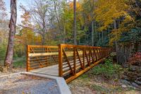
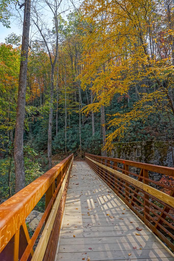
Currently undergoing improvements, the trail follows an old road from a huge new parking area, built in spring 2012. The first part is an easy walk on an old road bed through level woods. The river is far to the right, and an old pine plantation is on the left. The old road veers right to cross the river at the trail's old ford, but the trail goes left, slightly uphill, to a new, impressive footbridge over the Catawba River, installed in July 2016.
The river has a history as a power source for the town of Old Fort. Just to the left of the the footbridge is the remains of the old powerhouse. Other infrastructure for the power generator can be seen upstream.
On the other side of the bridge, the trail continues uphill on the old road through some nice forests. The Catawba River begins picking up gradient and you'll hear it cascading down to the left, until you pass just above a larger cascade. Be cautious of the sheer drop to the left of the trail at this point.
The cascade is just below the old dam which once supplied water to the powerhouse via a big wood-stave pipe that exited on the river right side of the dam. Look for a big hole there now.
Past the dam, look for another building foundation on the right. The Forest Service plans to remove the dam and this building at some point in the future.
Beyond the dam, the trail crosses Clover Patch Branch, an easy rock-hop, and then continues an easy ascent to Chestnut Branch. Right now the trail is a real mess at Chestnut Branch, but the Forest Service has plans to install another bridge there to aid the crossing. Just work your way up between the two channels of Chestnut Branch and pick up the trail heading upstream on the other side. A gigantic hemlock log dam marks the spot (and may make a good way across, if it's not wet and slippery).
Currently, the trail ends a short distance (and rocky climb) past the Chestnut Branch crossing at Lower Catawba Falls. An unofficial scramble path continues up the right side of the lower falls to the base of the upper falls. However, this path is just plain unsafe - parts of it are so steep you need rock climbing skills, and a fall would send you tumbling over the lower falls (which has actually happened here, and recently).
The Forest Service plans improvements to the trail to Upper Falls as well. Until that's done, it is signed as closed and dangerous.
This is one of the finest waterfalls in the region, but the lower falls isn't particularly photogenic except in just-right conditions. It's really something to look at, however, and a shallow pool at the flat base makes a great spot for wading (when the water is low).
This trail is located in the Catawba Falls area. For a list of all the trails in that area, see the Catawba Falls trails list page.
All Photos from the Trail


GPS Map
Map Information
Download GPS Data
Click on a route, trail, or point on the map and select the GPS Data tab to download its data.
Data Formats
KML (Google Earth)
KML is the main file type used by Google Earth. If you have Google Earth installed, clicking the KML link should open the trail or point directly in Google Earth for viewing. This is the native file format used by Google Earth, but many other map applications can use and understand KML as well, so if you're not sure which one to download, KML is a good bet.
GPX
The GPX format stands for GPS Exchange - a free, open, XML format for exchanging GPS and map data. GPX is compatible with Google Earth, many other mapping programs, and most GPS devices (such as Garmin). Load the file directly into your GPS to help find your way on your next trip!
GeoJSON
GeoJSON is a newer, lightweight data exchange format which can be used to quickly share map data and may have a smaller size than KML or GPX. Many professional mapping and GIS applications support the GeoJSON format.
About the Map
Copyright
Base Layers
Base layers provided by OpenStreetMap, the US Geological Survey, the US Forest Service, and NC OneMap. Base layer images are subject to the respective copyright policies of their owners. Base layers may not be available at all times due to system maintenance or outages.
WNCOutdoors Base Layer
The WNCOutdoors Base layer is provided by WNCOutdoors.info. It is licensed by Creative Commons Attribution 3.0.
Trail and Marker Overlays
Trail layers and downloadable data are all original works created by WNCOutdoors with guidance from a variety of sources, including ensembles of our own GPS tracks, user contributed GPS tracks, official maps and GIS data from government agencies, and field observations. WNCOutdoors data is made freely available under the Open Database License - you are free to copy and use it for any purpose under the terms of that license (summary).
Tips
- Hover over a trail to see it highlighted. Helps to see start and end points for an individual trail.
- Scroll and zoom the map before printing, and that view will persist into the printed image.
- Click a trail for more details and to download it individually.
Feedback
Ratings
Average Rating: 4.0 (rated 1 times)
Rate It Now:

Josh said: Hiked the Catawba Falls trail today (6/25/17). The trail to the lower falls is about 1.5 miles and pretty easy. Moderate elevation and no major rocks or roots. The lower falls were interesting as the water gets diverted as it cascades down creating several mini-falls. I imagine it looks different every time you go based on the amount of water coming down. The upper falls is an entirely different story. It is a short hike up the right side of the lower falls. However it is extremely steep and does not have very good footing. Someone has installed ropes in certain portions of the trail. The ropes, while not essential, made ascending and, in particular, descending much easier and safer. I would not recommend traversing this trail with small children or pets (I left my wife, kid and dogs at the lower falls). I would also recommend good hiking shoes and would not attempt it after a strong rain (slippery). The hike is worth it. The upper falls are gorgeous. According to news reports a hiker died at the upper falls the day before. I don't know the details but hike with caution.