Profile Trail

At A Glance


3.3 mi one-way
Difficulty Rating: 7.66 ![]()
Steepness: Climbs Steeply ![]()
Tread Condition: Moderately Rough ![]()
Lowest Elevation: 3800 ft
Highest Elevation: 5675 ft
Climb Total: 2100 ft
Blaze Color: Red with hiker symbol
Hikes That Use This Trail: Grandfather's Profile
Description
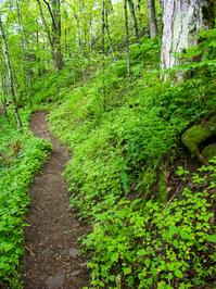
Probably the best way to "summit" Grandfather Mountain is via this fantastic trail, and I believe it's one of the finest trails in the state. The trail first winds through lush mid-altitude cove hardwood forests, with a few stream crossings and scenic cascades, one of which near the start is on a sturdy bridge. It climbs moderately at first and more steeply higher up, with many switchbacks. Sections created by master trailbuilders are laid from massive, flat stones arranged in stair-step fashion. The trail passes several views (both up and down), including one of the old man's "profile" which gave rise to the mountain's name. There are lots of big trees, rock features, and good water at Shanty Spring. Beyond that point it shoots straight up the mountain, gets very steep and rocky and transitions into the spruce-fir forest zone closer to the summit. The trail is generally well signed and blazed.
This trail is part of the Grandfather's Profile hike; see the hike description for more trail details.
Intersecting Trails
This trail is located in the Grandfather Mountain State Park area. For a list of all the trails in that area, see the Grandfather Mountain State Park trails list page.
All Photos from the Trail


GPS Map
Map Information
Download GPS Data
Click on a route, trail, or point on the map and select the GPS Data tab to download its data.
Data Formats
KML (Google Earth)
KML is the main file type used by Google Earth. If you have Google Earth installed, clicking the KML link should open the trail or point directly in Google Earth for viewing. This is the native file format used by Google Earth, but many other map applications can use and understand KML as well, so if you're not sure which one to download, KML is a good bet.
GPX
The GPX format stands for GPS Exchange - a free, open, XML format for exchanging GPS and map data. GPX is compatible with Google Earth, many other mapping programs, and most GPS devices (such as Garmin). Load the file directly into your GPS to help find your way on your next trip!
GeoJSON
GeoJSON is a newer, lightweight data exchange format which can be used to quickly share map data and may have a smaller size than KML or GPX. Many professional mapping and GIS applications support the GeoJSON format.
About the Map
Copyright
Base Layers
Base layers provided by OpenStreetMap, the US Geological Survey, the US Forest Service, and NC OneMap. Base layer images are subject to the respective copyright policies of their owners. Base layers may not be available at all times due to system maintenance or outages.
WNCOutdoors Base Layer
The WNCOutdoors Base layer is provided by WNCOutdoors.info. It is licensed by Creative Commons Attribution 3.0.
Trail and Marker Overlays
Trail layers and downloadable data are all original works created by WNCOutdoors with guidance from a variety of sources, including ensembles of our own GPS tracks, user contributed GPS tracks, official maps and GIS data from government agencies, and field observations. WNCOutdoors data is made freely available under the Open Database License - you are free to copy and use it for any purpose under the terms of that license (summary).
Tips
- Hover over a trail to see it highlighted. Helps to see start and end points for an individual trail.
- Scroll and zoom the map before printing, and that view will persist into the printed image.
- Click a trail for more details and to download it individually.
Trail Segments
Trails are often made up of several connecting paths which may have different characteristics, allowed uses, and seasons. This trail is divided into multiple segments as follows:
Profile - Parking to Old Trail
- Allowed Uses: Hiking
- Length: 0.78 mi
Profile - Along Watauga River
- Allowed Uses: Hiking
- Length: 0.13 mi
Profile - Watauga River to Foscoe View
- Allowed Uses: Hiking
- Length: 0.72 mi
Profile - Foscoe View to Profile Campsite
- Allowed Uses: Hiking
- Length: 0.86 mi
Profile - Profile Campsite to Profile View
- Allowed Uses: Hiking
- Length: 0.24 mi
Profile - Profile View to Shanty Spring
- Allowed Uses: Hiking
- Length: 0.36 mi
Profile - Shanty Spring to Grandfather Tr
- Allowed Uses: Hiking
- Length: 0.25 mi
Total Calculated Length: 3.34 mi
This value is derived from our underlying map data, and it may not match officially published information.
Feedback
Ratings
Average Rating: 3.2 (rated 22 times)
Rate It Now:

No comments yet.