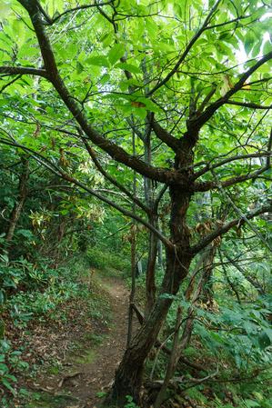
Climbing from Wash Creek Road uphill, the trail follows the ever-diminishing namesake stream along an old road bed, crossing it after a short distance. The forest is a typical cove hardwood variety with plenty of rhododendron and both healthy and...
Follows the creek uphill, starting in a clearing. Travels through mostly white pine and dead hemlocks, then into hardwoods mixed hardwoods near the small stream. Crosses and then ends on FS 5001, making a loop hike possible.
Follows one of the larger tributaries of the North Mills River. Many creek crossings on the lower half. Steep climb up the Pisgah Ridge on the upper half. High elevation change.
Creekside, backcountry trail. Numerous water crossings will require wading; not passable in high water. May require pathfinding skills - trail disappears into the creek at times. Passes small dam on Bradley Creek.
Connects the South Mills River trail with the middle of Squirrel Gap trail. Starting near the old Cantrell Creek Lodge site, the trail follows Cantrell Creek upstream on the river right side to where the former trail continues upstream (now part of...
Typical streamside trail for the most part, with cove hardwood forests, hemlocks, fern gardens and log bridges. Some muddy sections are out there, but the trail is mostly dry. It passes through some open meadows rimmed with flowering dogwoods near...
This is a short, but fairly steep connector trail, which enables some long loops for all users. This trail will take you through a nice stand of cove hardwoods, made up mostly of yellow poplar and oak. In the winter, you can see some of the distant...
Long, narrow, backcountry singletrack trail which reaches high elevations. Climbs gradually from Yellow Gap Road (FR 1206) to the Buck Spring Trail; however, there are a few steep sections. Several unmarked trails join from either side, so keep an...
The trail follows an old railroad grade; you may notice some of the old ties still in the ground. It follows or crosses the Middle Fork of the North Mills River for its entire length. You will pass some wildlife fields, which are maintained by the...
From the S. Mills River trail, climbs on an eroded old roadbed through nondescript forest to a nice campsite in a gap, just after crossing a small stream. The trail makes a hard right to the north on another road bed, which heads uphill into the...
In what could be one of the most bizarre naming situations in all of Pisgah, this trail is neither in a cove nor is it a loop. Rather, the best reasoning I can come up with for its name is that this ridge-top trail *enables* you to hike a loop above...
Starting at the eastern end, this trail begins by following Slate Rock Creek. This is an easy to moderate grade with several stream crossings. Slate Rock Creek is typical of mountain streams, with small cascades and an abundance of mosses and ferns....
Climbs somewhat steeply from Yellow Gap Road (FR 1206) up to the Buck Spring/Mountains to Sea trail near Mount Pisgah on the Parkway. Initially crosses a creek, then climbs through a cove forest gradually getting farther from it. Passes through many...
Poundingmill is a lightly used trail which connects the South Mills River and Squirrel Gap trails (#133 and #147, respectively). It is a moderate climb at first as it follows Poundingmill Branch almost the entire way. There are numerous stream...
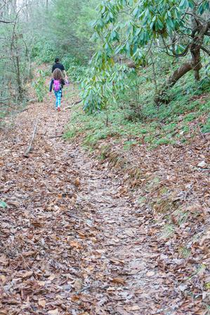
As its name implies, this trail follows the river (South Mills) and Bradley Creek, both of which you cross several times. Scenic. Expect to get wet up to your knees on this one. Impassible in high water.
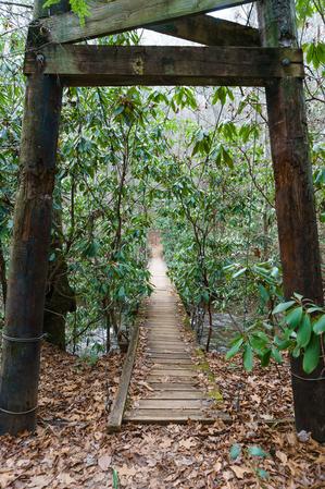
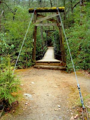
This is a stream side trail along an old road bed for much of its length; pulls away from the river along one section around High Falls. Crosses the river using bridges (concrete and suspension bridges) and fords it many times as well. There are some...
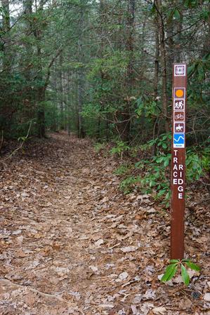
The upper end of this trail, above FS 5097 (Neverending Road), was recently rerouted onto a much more reasonable grade with a few switchbacks, to replace the old, extremely steep and rocky drop down from Trace Ridge. It's now an easy climb or...
This is a long, backcountry trail. It's purpose-built trail that doesn't follow many logging roads - a rarity in Pisgah. From where this trail leaves the Bradley Creek Trail, it follows an easy grade to the old Mullinax homeplace where there is a...
Climbs steeply from FS 1206 to the Pilot Rock trail near the summit of Little Bald Mountain. Starts in a cove with one significant creek crossing, through young cove forest. Winds up passing through several switchbacks into an older, yet shorter,...
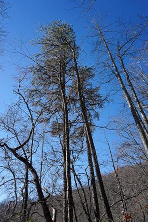
The upper portion above the Trace Ridge trailhead follows an old roadbed up the ridge all the way to the Blue Ridge Parkway. Rocky; steep. Very eroded in places. Dry pine-oak forests can be found along the nondescript ridge.
Downhill from the...
Long ridgeline trail which undulates up and down over the various knobs on its summit. Very steep in places; has some issues with erosion as well. It winds onto the edge of private land in places; stay on the trail. Travels through a typical...
Climbs from the Mills River up to Wagon Road Gap on the Turkey Pen Gap trail through a pleasant cove forest. It enables the only (day hike) loop from the Turkeypen trailhead parking using the Turkey Pen Gap trail.
The bottom-most portion passes...
Short connector from Hendersonville Reservoir Road, FS 142, to the Trace Ridge trail on an old road bed. Crosses a small seep and passes into a recently logged area near the junction.
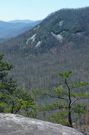
This heavily-used trail features incredible views, hiking along a needle-sharp ridgeline, and lots of rock outcroppings and boulders. The trail itself is notable (unfortunately) for its heavily eroded sections. Either through erosion or work to...
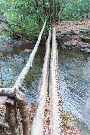
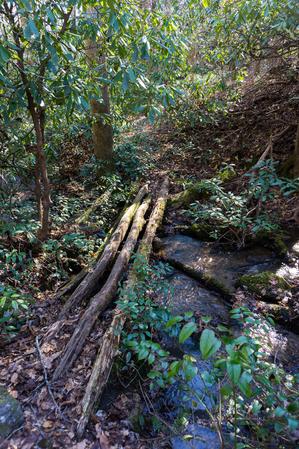
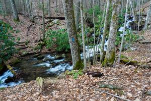
This fairly long trail has several creek crossings on its south end. These are completed via either log bridges or rock-hops and wades. The stream runs through a beautiful cove hardwood forest. There were formerly dense hemlock groves with some huge...
Pleasant, easy trail travels through the lowlands beside Foster Creek, in a rather detached section of Pisgah National Forest. No intersections with any other trails (except the old logging road). Mostly white pine and cove hardwood forests, with an...
An excellent loop which travels around the bottom of a unique valley. This is the "Cradle of Forestry in America", where modern forestry techniques were first developed, taught & practiced. Trail is mostly level with a few small hills on north...
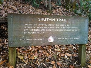
The Shut-In Trail is a long, historic route which shares the path with the Mountains to Sea Trail. It travels from NC 191 near Bent Creek and Asheville to the Mount Pisgah parking area. George W. Vanderbilt, builder of the famous Biltmore Estate near...
**Pisgah Inn to Black Mountain Campground**
Pisgah Inn, BRP mp 408.6 to Folk Art Center, BRP mp 382: from the Pisgah Inn to the Mount Pisgah Parking Area, the trail is co-signed as the Buck Spring trail. This leads past the old Buck Spring Lodge...
**Waterrock Knob to Pisgah Inn**
From Waterrock Knob to Flat Gap, the trail follows the Blue Ridge Parkway closely at most times. It gains some distance from the motor road on the southwest slope of the ridge line from there to Haywood Gap.
From...


")