Linville Falls - Erwin's View Hike

Linville Falls has two main trails: Erwin's view and Plunge Basin. Erwin's view is the easier of the two, and stops at three main overlooks: Upper Falls, Chimney View, and the eponymous Erwin's View. This trail passes through a majestic forest of old-growth hemlock and white pines, to spectacular cliff-top views of one of the most scenic and photographed waterfalls in the East. Spectacular views of the falls, the surrounding mountains, and the Linville Gorge await.
At A Glance
 1.5 mi round-trip
Difficulty Rating: 2.18 ![]()
Tread Condition: Some Obstacles ![]()
Climb: Few Hills ![]()
Lowest Elevation: 3160 ft
Highest Elevation: 3360 ft
Climb Total: 300 ft
Configuration: Out-and-back
Starting Point: Linville Falls Visitor Center
Trails Used: Erwins View
Hike Start Location
Directions
From Asheville: There are several acceptable routes to get to Linville Falls from Asheville.
Via the Blue Ridge Parkway: Access the Blue Ridge Parkway. From US 70 (Tunnel Road), it's about 67 miles to the spur road to Linville Falls on the right. Turn right and park at the visitor center.
Via Burnsville: Slightly quicker is to head West on Interstate 26 from Asheville. Take exit 9, for US-19 N, toward Spruce Pine/Burnsville. In Spruce Pine, turn right at NC-226 and go just under 5 miles to the Blue Ridge Parkway. Turn left onto the ramp, then left (North) on the Parkway, and travel about 14 miles to the Linville Falls area. Turn right on the spur road to falls, and park at the Visitor Center.
The Quickest Route: This route is also the least scenic, but will get you there the fastest. Take I-240 E to I-40 E and go about 18 miles. Take exit 72 to merge onto US-70 toward Old Fort. Go about 11 miles and turn left on US-221. Stay on 221 for about 22 miles until you reach the Blue Ridge Parkway. Turn right up the ramp; turn left (North) on the Parkway and go about a mile. Turn right on the spur road to falls, and park at the Visitor Center.
Details
Hike Description

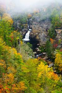
This wide, well-maintained trail takes you to three spectacular views of Linville Falls on the west side of the gorge - Upper Falls (.5mi), Chimney View (.7mi), and Erwin's View (.8mi), passing through a majestic evergreen forest along the way.
Although the park literature calls this a "strenuous" climb, it is only so by a casual Parkway visitor's standard so don't let that turn you away. If you're that casual Parkway visitor, there is one decent workout to be had near the middle of the hike, but you can take it slow - and it's worth doing in order to enjoy the spectacular forest you're walking through anyway. Side trails to the first two overlooks are a bit rougher, with some rock steps, but well worth the effort. But overall, as trails go, this one is just moderate.
Starting from the visitor center (straight through the breezeway), cross over the Linville River on a wide concrete bridge. Past the bridge, the trail follows the tranquil river through a forest with some large trees, then climbs away from the river a bit. You'll meander up and down, crossing over small tributaries. Pass through a small, open meadow, and then reach an intersection with a side trail on the right. That trail leads to the overflow and winter time gravel parking lot. Continue straight.

Just ahead is the signed intersection with the spur to the Lower Falls overlook. It is 500' and slightly downhill to the overlook. The side trail passes through some more large trees, and through a slot in a large, broken rock. At the overlook, looking upstream, you'll see the 15 ft. Upper Falls and the huge pool below them. Downstream, you see into the neat slot canyon above the lower falls. It's a neat view, but not as dramatic as the view of the entire falls from Chimney View or Erwin's View up ahead. To reach those, go back to the intersection with the main trail.
Continuing uphill on the main trail from the intersection, you'll pass beside another open meadow. The size of the trees growing here has a real impact on the scenery. On the left grows a huge Eastern hemlock; on the right, a big, spidery white pine with long, lanky limbs. Just beyond this meadow, the trail begins the most significant climb on the hike.
Despite the climb, the surface still mostly smooth, and there are plenty of places to stop and rest. Besides, the forest you are in is worth a closer look anyway! This is an old growth forest, consisting largely of Eastern Hemlocks, White Pines, and to a lesser extent, Carolina Hemlocks. Historically, these three evergreens thrived in the acidic soils found here. Unfortunately,the Hemlocks are in decline due to the Hemlock Wooly Adelgid infestation that took place during the mid 2000's.
The Eastern Hemlock trees directly beside the trail were treated to fight off the adelgids, and while a few died anyway, most remain healthy. However, a vast swath of forest off to the south of the trail wasn't treated and has completely died. You'll have to use your imagination - maybe with the help of our old photo - to conjure what it looked like when the tall, dark evergreen trees went as far up the little side valley as you could see from the trail.

As you crest the top of this hill, you'll come to the side path to Chimney View on the left. Some tall white pines grow there. It's a short path down a steep set of steps (and, unfortunately, eroded water bars) from there to the overlooks, which are WELL worth the climb back out to see the view. Don't skip this one.
From Chimney View, there is an excellent view of the falls just up the river from your location. You can see the cliffs surrounding the falls, and you get a view directly down to the river itself. Below you, between the overlook where you're standing and the river's edge is a huge cliff. Standing off from the base of the cliff are two tall pillars of rock that look like chimneys, hence the overlook's name. There is also a good view down the gorge and to the surrounding ridges from the overlook. The rarer Carolina Hemlock grows in its conical form on the rock outcrops around this overlook. A few have died, but thankfully most remain healthy through the Park Service's treatment plan.
To continue to Erwin's View, hike back up the steps to the main trail and turn left. Back on the main trail, it's just a short distance to Erwin's View. The trail does climb up some more, and it's a tad rougher than the rest of the trail up to this point - but still quite moderate overall.
There are actually two overlooks at Erwin's View. The first one you come to is down on the right and has a great view of the gorge downstream. Check it out, then climb up to your left just a few feet to the main overlook. It's on top of a large, flat boulder which you'll reach by climbing up a set of wooden steps.
You're a bit farther from the falls here than at Chimney View, and you not only get a spectacular view of those, but also of the surrounding mountains and ridges. There is a nice crop of healthy Carolina hemlock trees, whose form resembles the spruces and firs you'd find higher up the mountains more than their Eastern hemlock cousins. Their presence gives the overlook a neat, alpine feel.

At this point you've climbed to an elevation of 3330', and it's the highest point on the hike. This marks the end of the hike as well; return to your vehicle on the same trail.
All Photos from This Hike


Map
Green highlight indicates the route to follow within the trail network for this hike.
Tip: Printing this map? You can pan and zoom the map as desired before printing to show the area you need.
Map Information
Download GPS Data
Click on a route, trail, or point on the map and select the GPS Data tab to download its data.
Data Formats
KML (Google Earth)
KML is the main file type used by Google Earth. If you have Google Earth installed, clicking the KML link should open the trail or point directly in Google Earth for viewing. This is the native file format used by Google Earth, but many other map applications can use and understand KML as well, so if you're not sure which one to download, KML is a good bet.
GPX
The GPX format stands for GPS Exchange - a free, open, XML format for exchanging GPS and map data. GPX is compatible with Google Earth, many other mapping programs, and most GPS devices (such as Garmin). Load the file directly into your GPS to help find your way on your next trip!
GeoJSON
GeoJSON is a newer, lightweight data exchange format which can be used to quickly share map data and may have a smaller size than KML or GPX. Many professional mapping and GIS applications support the GeoJSON format.
About the Map
Copyright
Base Layers
Base layers provided by OpenStreetMap, the US Geological Survey, the US Forest Service, and NC OneMap. Base layer images are subject to the respective copyright policies of their owners. Base layers may not be available at all times due to system maintenance or outages.
WNCOutdoors Base Layer
The WNCOutdoors Base layer is provided by WNCOutdoors.info. It is licensed by Creative Commons Attribution 3.0.
Trail and Marker Overlays
Trail layers and downloadable data are all original works created by WNCOutdoors with guidance from a variety of sources, including ensembles of our own GPS tracks, user contributed GPS tracks, official maps and GIS data from government agencies, and field observations. WNCOutdoors data is made freely available under the Open Database License - you are free to copy and use it for any purpose under the terms of that license (summary).
Tips
- Hover over a trail to see it highlighted. Helps to see start and end points for an individual trail.
- Scroll and zoom the map before printing, and that view will persist into the printed image.
- Click a trail for more details and to download it individually.
Feedback
Ratings
Average Rating: 2.4 (rated 103 times)
Rate It Now:

[Site Admin] Jordan M. said: @Kelsey These photos are combined from a few different trips. The fall color photos were from October 12, 2014. There's a shot of some pink flowers by a little bridge which was in September, but no fall color at that point! Those (and other late summer/fall wildflowers) do bloom into October, though.
Kelsey said: What month are these photos in with the full bloom but all yellow leaves turning
Vann Helms said: The walk through the ancient Hemlock forest is almost as exciting as the falls vista. Go mid-week to avoid the crowds. Don't miss it....