Ridgewalk Hike

Following the mostly level upper portion of the Bennet Gap trail, this is an easy hike along a ridge to some great views. It's one of the easiest true hikes into the kind of neat environment typical of a rugged Appalachian ridgetop that we could find. Watch the forest transition as you hike and the ridge becomes drier, rockier, and narrower. This hike is suitable for families with children, where learning opportunities abound, and makes a great destination of its own or addition to another hike in the area.
At A Glance
 1.4 mi round-trip
Difficulty Rating: 1.76 ![]()
Tread Condition: Some Obstacles ![]()
Climb: Few Hills ![]()
Lowest Elevation: 3516 ft
Highest Elevation: 3580 ft
Climb Total: 125 ft
Configuration: Out-and-back
Starting Point: Avery Creek Road (FR 477) at Bennett Gap, between the Pink Beds and the Pisgah Horse Stables
Trails Used: Bennett Gap
Hike Start Location
Directions
From Asheville, take I-240 west to I-26 east. Take exit 40 for the Asheville Airport/NC 280 and turn right (south) Follow NC 280 for 16 miles, through Mills River to Brevard. At the intersection with US 64/276, turn right onto US 276 and enter the Pisgah National Forest. Go 2.3 miles and turn right on gravel FS 477. Follow 477 for about 4.8 miles (it's twisty and narrow in places) uphill. The Bennett Gap trail starts on the left just before the top of the mountain at an old gate. There is parking for 4-5 cars on the right. (Don't be confused by some other old roads leading off to the left in the same vicinity as the Bennett Gap Trail - it is well used, signed, and blazed, so you'll know it when you're there).
FS 477 can become somewhat rough between periods of maintenance, and may be tricky to navigate with an average passenger car at times - though it's usually not impassible. The section of FS 477 from the trailhead north to its other junction with US 276 may be in better shape - use a map and come south on FS 477 from that direction if you're unsure about your vehicle. The Bennett Gap trail will then be on your right.
Details
Hike Description

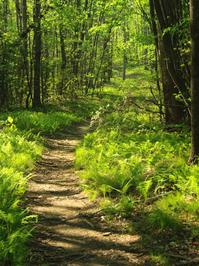
Begin the hike behind the metal gate. A sign for the Bennett Gap trail stands beside the old roadbed, which is now a trail. The rocky old road begins a short climb through some young woods, with lots of vines growing in the trees. Sections of the woods are open, with the ground covered by grass and ferns.
The climb is not very difficult, and after about 1/4 mile it levels off before entering an open meadow on top of the ridge. The meadow is kept open by the Forest Service by mowing, in order to provide habitat for wildlife that likes open, grassy areas - or those that like to live near the edge of such openings. If you're quiet, you might see something here - perhaps a deer, rabbit, or groundhog.
Follow the trail through the meadow, and exit into the woods on the other side. The woods here are similar to the ones on the other side, and lots of ferns grow in between the trees. The trail remains nearly level at this point. Gradually, the ridge starts to steepen on either side of the trail. As this happens, watch for a noticeable change in the vegetation.
As you near the 1/2 mile point, the old road bed you've been following ends and the path becomes a purpose-built trail. You'll start to notice how narrow the ridge becomes. The soil is rockier here and less rich than farther back on the ridge, and the trees start to get shorter and gnarlier. Mountain Laurel and rhododendron begins to fill in the understory. Exposure to the elements and perhaps (in the past, at least) more frequent wildfires contribute to the changing nature of this forest on this steeper part of the ridge.
The trail goes downhill a bit and there will start to be some rocks in the path, although they're not too bad at first. You might notice a short side path heading to the right, which leads to a good view to the southwest. On a clear day, especially during fall or spring, it's a spectacular vista, with Looking Glass Rock and the high Balsam Mountains to the far right, and further to the left, craggy John Rock and Cedar Rock Mountain with folds of ridges leading up to it.

This is a great place to stop and enjoy a snack. If you wish, you could end the hike here - this would make a worthy destination even if you didn't go any farther! Stay back from the edge - although it is not a cliff, per se, it's a steep drop over the side of the ridge right here.

If you wish to continue, go back to the trail and turn right, resuming the downhill walk. This section gets a bit rockier with some steps in one spot. It goes around a short switchback. (Keep in mind you'll have to hike this uphill on the way back). About 100 feet past the switchback, and 0.7 miles from the trailhead, the trail goes up over a tiny knoll on the narrow ridge (though it's only about a 15 foot climb).
On the left is a protruding rock below a group of pine trees. There are some more excellent views from atop this rock. To the northeast, the neighboring ridge - Black Mountain - can be seen. You can also see back toward Looking Glass Rock from here, but mainly in the winter.
This rock marks the end for this hike, although the trail continues and starts to drop steeply, eventually to come out on Avery Creek Road near the horse stables. Return to your vehicle on the same path.
All Photos from This Hike


Map
Green highlight indicates the route to follow within the trail network for this hike.
Tip: Printing this map? You can pan and zoom the map as desired before printing to show the area you need.
Map Information
Download GPS Data
Click on a route, trail, or point on the map and select the GPS Data tab to download its data.
Data Formats
KML (Google Earth)
KML is the main file type used by Google Earth. If you have Google Earth installed, clicking the KML link should open the trail or point directly in Google Earth for viewing. This is the native file format used by Google Earth, but many other map applications can use and understand KML as well, so if you're not sure which one to download, KML is a good bet.
GPX
The GPX format stands for GPS Exchange - a free, open, XML format for exchanging GPS and map data. GPX is compatible with Google Earth, many other mapping programs, and most GPS devices (such as Garmin). Load the file directly into your GPS to help find your way on your next trip!
GeoJSON
GeoJSON is a newer, lightweight data exchange format which can be used to quickly share map data and may have a smaller size than KML or GPX. Many professional mapping and GIS applications support the GeoJSON format.
About the Map
Copyright
Base Layers
Base layers provided by OpenStreetMap, the US Geological Survey, the US Forest Service, and NC OneMap. Base layer images are subject to the respective copyright policies of their owners. Base layers may not be available at all times due to system maintenance or outages.
WNCOutdoors Base Layer
The WNCOutdoors Base layer is provided by WNCOutdoors.info. It is licensed by Creative Commons Attribution 3.0.
Trail and Marker Overlays
Trail layers and downloadable data are all original works created by WNCOutdoors with guidance from a variety of sources, including ensembles of our own GPS tracks, user contributed GPS tracks, official maps and GIS data from government agencies, and field observations. WNCOutdoors data is made freely available under the Open Database License - you are free to copy and use it for any purpose under the terms of that license (summary).
Tips
- Hover over a trail to see it highlighted. Helps to see start and end points for an individual trail.
- Scroll and zoom the map before printing, and that view will persist into the printed image.
- Click a trail for more details and to download it individually.
Feedback
Ratings
Average Rating: 3.0 (rated 4 times)
Rate It Now:

Ben M. said: We followed Tim’s lead and approached on 477 from the North w/ a hybrid sedan. No AWD / 4WD necessary. It was indeed 2.4 miles from the turn off. We also found Teddy Z’s comments helpful in distinguishing the Bennett Gap road from the Trailhead (although the Trailhead was very well marked). There is parking on both the right and left side of the road for several cars. This trail seems to be popular with mountain bikers. We shared the trail with about a dozen, who continued on past the end of the Riddgewalk hike. A very enjoyable short walk w/ good variety and some excellent views of Looking Glass Rock. Thank you HIkeWNC and commentors for the very helpful info.
Teddy Z said: Wish I had read all the comments before starting out! When approaching the trail from the North end of FR477, where it crosses US276, I found FR477 blocked off part of the way down, so I continued south on US276 until FR477 crossed it again, made a left on FR477, and tried approaching the trail from the South end of FR477 (going North on FR477). There was a warning sign part way down saying FR477 was closed further ahead. Fortunately, the closing was just a few feet AFTER the trailhead. One source of confusion was this part of the directions: "There is parking for 4-5 cars on the right." I assumed that meant on the right side of the road. But that is not the case. There is some space for parking on the LEFT side of the road, where the trailhead is, just to the right of the TRAILHEAD. For about 3 or 4 cars, in my estimation, not 4 or 5. The main source of confusion was that there is a Bennet Gap Trail and a Bennet Gap Road. A few feet further north on FR477, after Bennet Gap Trail, closer to the "top of the mountain," is Bennet Gap ROAD - behind a similar gate. And, indeed, it was on Bennet Gap ROAD where I walked for a mile - on a ROAD as the directions said I should be - before realizing that I was on the wrong trail - there were no trail blazes or trail markers of any sort. After I returned to this "trailhead" and looked more closely at the signpost at the "trailhead," I saw the word "Rd" at the very bottom of the signpost, partly obscured by plant growth. After walking back to my car, I finally found the trailhead - just to the left of where I had left my car! I had left my car in the parking spot described in the directions - just to the right of the trail. To the left of my car was a gate, and to the left of the gate was the sign post that said Bennet Gap TRAIL - but the sign post had been fairly well obscured by plant growth so I hadn't seen it earlier. I'll have to come back another day and hike the TRAIL instead of the road.
Teddy Z said: Wish I had read all the comments before starting out! When approaching the trail from the North end of FR477, where it crosses US276, I found FR477 blocked off part of way down, so I continued south on US276 until FR477 crossed it again, made a left on FR477, and tried approaching the trail from the South end of FR477 (going North on FR477). There was a warning sign part way down saying FR477 was closed further ahead. Fortunately, the closing was just a few feet AFTER the trailhead. One source of confusion was this part of the directions: "There is parking for 4-5 cars on the right." I assumed that meant on the right side of the road. But that is not the case. There is some space for parking on the LEFT side of the road, where the trailhead is, just to the right of the TRAILHEAD. For about 3 or 4 cars, in my estimation, not 4 or 5. The main source of confusion was that there is a Bennet Gap Trail and a Bennet Gap Road. A few feet further north on FR477, after Bennet Gap Trail, closer to the "top of the mountain," is Bennet Gap ROAD - behind a similar gate. And, indeed, it was on Bennet Gap ROAD where I walked for a mile - on a ROAD as the directions said I should be - before realizing that I was on the wrong trail - there were no trail blazes or trail markers of any sort. After I returned to this "trailhead" and looked more closely at the signpost at the "trailhead," I saw the word "Rd" at the very bottom of the signpost, partly obscured by plant growth. After walking back to my car, I finally found the trailhead - just to the left of where I had left my car! I had left my car in the parking spot described in the directions - just to the right of the trail. To the left of my car was a gate, and to the left of the gate was the sign post that said Bennet Gap TRAIL - but the sign post had been fairly well obscured by plant growth so I hadn't seen it earlier. I'll have to come back another day and hike the TRAIL instead of the road.
[Site Admin] Jordan M. said: @Tim - thanks for the note, we noticed that FS 477 was getting rough and the stretch of it north to US 276 was in better shape last time we visited too (Fall 2015) and we've updated the directions to reflect that, as well as the "ghost roads" leading into the woods near the trail!
Tim said: My wife, almost 4-year old daughter, and almost 2-year old son hiked this today (May 4, 2016). It was a great suggestion. It was challenging enough to push the kids a bit, but it was easy enough that they mostly enjoyed themselves. We hung out at the lookout spot for 20 minutes or so as the kids played on the rocks in the trail. We carried both kids in backpacks for part of the hike, and that worked well from the meadow to the overlook. That part has some exposed rocks and a few climbs our kids would have found challenging. The hike from the trailhead to the meadow is somewhat easier. The trail was well maintained and easy to follow. There is a sign up now that indicates the trail is for Bennett Gap. The Forest Service road is rougher than some of the other FS roads I've been on around here (and elsewhere). We got our Honda Odyssey to the trailhead, but we were going pretty slow for the last couple miles. Micki's and Brad's points helped us avoid any wrong turns. A couple other notes: I clocked the distance from US276 to the trailhead as 4.8 miles. I re-joined US276 by going North on FR477, and that was only 2.4 miles. That portion of the FS road was also better. All in all, this was exactly the hike my kids needed. We had a great time.
Brad said: Sept. 2015, Just hiked the trail today. Started hiking then realized nothing was right. Drove a little up the road and found the right spot. I understand how Heather got lost. The trail is clearly marked and maintained. Overall it was a pleasant walk in the woods. A perfect beginner trail for my two year old.
Micki Krieger said: We decided to chance it despite Heather's review and agree with Jordan that she hiked the wrong trail. The give away was her comment about the meadow. We found the meadow readily, less than five minutes from the gate. That said, there are a few things worth noting. First of all, there is no parking area on the right. And there are TWO gates around the corner from each other, both on the left. Park at the second. The sign says "Bennett Gap Road". We weren't sure if that was the trail but fortunately a kind gentlemen camping just to the left of that second gate advised us to walk back down FR477 (literally around a near bend) to the first gate. This was not marked either but he said that one trail went down, the other up and to take the one that went up. Within 100 feet on the trail that went up we found the Bennett Gap Trail sign broken and tossed into the brush. The rest of the hike is as described and we enjoyed it.
[Site Admin] Jordan M. said: Sorry to hear that you didn't enjoy it. Something tells me that you might not have found the correct trailhead, though...the trail has always been signed, blazed, and fairly well maintained when I hiked it, and the meadow is maintained as a wildlife opening with mowers. Nevertheless, conditions do change and trails can quickly become overgrown if not maintained. Thanks and we'll check it out next time we're down there!
Heather said: As of May 15, 2013 this trail is overgrown and poorly maintained. The description above is completely day and night as to what the hike is now. I could see not views. I could hardly tell were the trail was going at times. I never saw a open meadow, or a purpose built trail. I did see some big tarp laying over something with carpet sticking out. My friend and I got cut to shreds by thorns on bushes and there is a lot of run off which leads to almost impassable muddy places. I never got to the end of this trail, and it was a long drive up to the trail for nothing. And I never saw any blaze at all for this trail. The forest service should warn hikers that his trail is too grown up to try to hike. I will never again go on this hike. But the Moore Cove Falls hike was wonderful.