Table Rock Hike

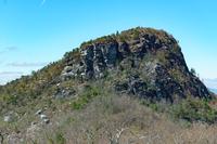
This trail climbs steeply to the top of a knife ridge, which from afar looks flat, giving the mountain its name. Though the rugged peak won't seem much like the surface of a table when you're standing on it, the views are unparalleled and worth the strenuous climb. The hike to Table Rock is not actually a wilderness trail - being one of the few developed, maintained, and signed trails just outside the wilderness boundary on the gorge's rim. But the views into the Gorge are spectacular, and from the top, you'll get the same kind of inspiring feelings that the wilderness can provide.
At A Glance
 2.0 mi round-trip
Difficulty Rating: 3.51 ![]()
Tread Condition: Moderately Rough ![]()
Climb: Climbs Moderately ![]()
Lowest Elevation: 3280 ft
Highest Elevation: 3940 ft
Climb Total: 660 ft
Configuration: Out-and-back
Starting Point: Parking area at the end of Table Rock Road
Trails Used: Table Rock Summit, Mountains to Sea Section 4
Hike Start Location
Directions
From the intersection of US 221 and NC 181 in Linville, NC, head south on NC 181 for 1.6 miles. Turn left on 181 and go 1.8 miles. Turn left to stay on NC 181 and go 6.4 miles. Turn right onto Ginger Cake Road - there are signs for Table Rock from here on out. Bear left after 0.3 miles onto Table Rock Road (FS 210). It's 5.4 miles on this curvy, narrow, bumpy gravel road to FS 210B - turn right here, and go another 1.3 bumpy miles. Turn right again onto Old Table Rock Road, which becomes paved and goes through a series of impossibly steep switchbacks before ending at the picnic area. All the gravel roads are bumpy, but maintained, and should be passable in passenger cars.
Details
Hike Description

Begin the hike at the north end of the parking lot (the side away from the toilets). The trail begins to the right of the sign board. The ridge of Table Rock looms high above the parking area right from the start. The trail starts out level, but very quickly begins its steep, mostly relentless climb to the top. You'll pass through a vast spread of Mayapple, particularly noticeable in the spring months.
Not only is it somewhat steep, but the trail quickly becomes very rocky. There is nothing particularly egregious, but some stretches have large stepping stones that have become dislodged and loose due to heavy hiker traffic. Some stretches of the trail sport smooth, sloping rock, so watch your footing to avoid a slip.
The beginning of the trail is in a forest of medium-height hardwood trees; mostly oaks. A few hemlocks and white pines grow in the understory, hoping to overtake the hardwoods and poke out into the sun some decades into the future.
But the forest quickly changes, and the trail becomes more open and sunny. In years past, this area was a forest, composed primarily of a species scraggly tree called Table Mountain Pine. But many of those have died as a result of an infestation of the native Southern Pine Beetle. Only the gnarled trunks now remain. Luckily, this insect has evolved along with the pines, so the trees aren't all killed by an infestation. Sparse sections of healthy pine forest can still be found.


This forest has also been affected by fire. In fact, these pines need fires periodically to open their cones and regenerate from seed. Along the way, you'll see signs explaining fire ecology which mention this fact. Aside from the pines, trailside vegetation consists mostly of rhododendron and mountain laurel. They are prolific, and bloom relatively early here (late May), which is an excellent time to hike this trail.
To your left, a nice view opens up through the sparse trees of the Linville Gorge and - to the far left - the Chimneys. These rock formations are some of the closest features we have in the Appalachians to "hoodoos" so common out west - pillars of rock standing apart from a main cliff face, formed by erosion. They are a popular rock climbing destination (as is Table Rock itself) and even have a connection to the famous Linville Falls some miles up the Linville River from this location.
Linville Gorge was formed as the Linville River cut down through a hard, resistant layer of rock into the softer rocks below. Where the river flows over this layer near the top of the gorge, it forms Linville Falls. The Chimneys, Table Rock, Hawksbill Mountain (which you will see once you reach the top), and all the high cliffs near the rim of the Gorge are all formed as a result of that same ancient, erosion-resistant layer of rock. At one point, the trail passes through a neat slot formed by a large boulder that has split away from the main rock face.
As you ascend, and once you reach the top, keep your eyes peeled for the elusive Peregrine Falcon. These graceful, large raptors are native to the area. They are, in fact, widespread across much of the world. But they were eliminated regionally during the 20th century due to the effects of DDT. Since then, they've been reintroduced to the area successfully and are still protected. Rock climbing routes near their high, windy cliff-side nesting sites are closed periodically to ensure that the birds are able to hatch and raise their offspring in peace. The Peregrine's most well-known feature is their hunting style: taking other birds in mid-flight, they dive from high above, striking their prey at literally breakneck speeds.

The trail will go around a ridge and curve to the right. An intersection with a faint path - the old Little Table Rock trail - is at the top of the ridge; bear right, uphill. You will immediately pass onto the cooler, wetter side of the mountain. Here, Carolina Hemlocks grow among the pines and hardwoods with a few Eastern hemlocks as well.
Both hemlock species are being ravaged by the Hemlock Wooly Adelgid, a non-native pest that has a lot less mercy on its host than the pine beetles have. These on Table Rock are still hanging on as of 2021 and some of them look perfectly healthy and unaffected by adelgid. They may have been treated chemically with insecticides to prevent the Adelgids from taking hold.
There is another intersection on the left; this time, with the Mountains to Sea Trail. Bear right, uphill. The rest of the trail is unblazed.
The trail switches back again, climbing in earnest, and goes back onto the open, sunny south side of the mountain. There are some side-paths going in all directions, but just follow the most well-worn path to stay on the main trail. Several rock formations stand out along this section of trail.
As you approach the top, the vegetation gets reduced down to very short, gnarled growth. It's mostly shrubs with a few stunted trees. But that means the views begin to really open up! The trail officially ends on a small flat area where an observation tower once stood. Despite the tower's absence, views are to be had in every direction, and they are spectacular.

You can travel along the ridge to the south if you're willing to scramble and climb over some very rough rocks. Keep in mind that there are sheer cliffs in almost all directions from the top and stay well back away from the edges. Also, obey any signs posted regarding closures for the Peregrine Falcons during the spring nesting season.
Once you are finished soaking up the views, return to your vehicle on the same path.

Extended Hike Option (+2 mi, minimal elevation change): If you've still got some time and energy to extend your hike, continue straight across the parking lot onto the Mountains to Sea trail and continue through the Table Rock Picnic Area. It's about a mile out to the Chimneys area of Linville Gorge, a rugged section of the ridge offering up more absolutely spectacular rock formations and views like those on Table Rock.

All Photos from This Hike


Map
Green highlight indicates the route to follow within the trail network for this hike.
Tip: Printing this map? You can pan and zoom the map as desired before printing to show the area you need.
Map Information
Download GPS Data
Click on a route, trail, or point on the map and select the GPS Data tab to download its data.
Data Formats
KML (Google Earth)
KML is the main file type used by Google Earth. If you have Google Earth installed, clicking the KML link should open the trail or point directly in Google Earth for viewing. This is the native file format used by Google Earth, but many other map applications can use and understand KML as well, so if you're not sure which one to download, KML is a good bet.
GPX
The GPX format stands for GPS Exchange - a free, open, XML format for exchanging GPS and map data. GPX is compatible with Google Earth, many other mapping programs, and most GPS devices (such as Garmin). Load the file directly into your GPS to help find your way on your next trip!
GeoJSON
GeoJSON is a newer, lightweight data exchange format which can be used to quickly share map data and may have a smaller size than KML or GPX. Many professional mapping and GIS applications support the GeoJSON format.
About the Map
Copyright
Base Layers
Base layers provided by OpenStreetMap, the US Geological Survey, the US Forest Service, and NC OneMap. Base layer images are subject to the respective copyright policies of their owners. Base layers may not be available at all times due to system maintenance or outages.
WNCOutdoors Base Layer
The WNCOutdoors Base layer is provided by WNCOutdoors.info. It is licensed by Creative Commons Attribution 3.0.
Trail and Marker Overlays
Trail layers and downloadable data are all original works created by WNCOutdoors with guidance from a variety of sources, including ensembles of our own GPS tracks, user contributed GPS tracks, official maps and GIS data from government agencies, and field observations. WNCOutdoors data is made freely available under the Open Database License - you are free to copy and use it for any purpose under the terms of that license (summary).
Tips
- Hover over a trail to see it highlighted. Helps to see start and end points for an individual trail.
- Scroll and zoom the map before printing, and that view will persist into the printed image.
- Click a trail for more details and to download it individually.
Feedback
Ratings
Average Rating: 2.1 (rated 75 times)
Rate It Now:

Rose hawley said: We are not happy that we missed see view mountain during color we did went there this morning as diappoined as nit find good place as you need big sign where is table rock we will go back east of nc
Mike Locke said: Who "saved" Linville Gorge for thousands of years as it burned naturally before we suppressed fire? Fires wouldn't need to be managed there at all if there weren't vacation homes inappropriately built too close to one of the most fire prone areas in the NC mountains. You should retitle your website "Save our McMansions"
sally james said: you have described beautifully one of the most popular Linville Gorge hikes!! i am sending a link below to a site formed to stop the destruction of this special place. following are the beginning comments i've made in a petition to the USFS against their proposed burn of the entire 16000 acreas including the spectacular gorge itself: "WILDERNESS NO MORE—Is this the intent of the current burn proposal by the USFS? We have all read by now the definition of “wilderness” either provided by that visionary act of Congress, the Wilderness Act of 1964, or from other sources. This so-called “wildness” will cease to exist for the Linville Gorge, the oft-called Grand Canyon of the East, if such a proposal as this goes through. Another “managed forest” will be what we are left with." There are many excellent, well-documented comments on the petition site which you can read under the comments section of our petition by first going to: http://savelgw.org/ which is the website we've formed to fight this FS proposal--it includes an easy link to our petition. i would invite you and your friends to sign on our behalf. we have only a few days left. and, please fee free to contact any of us. thank you! sally james, jonas ridge nc and winter park fl