Mountains to Sea Section 4 Trail

At A Glance


75.2 mi one-way
Difficulty Rating: 75.2 ![]()
Steepness: Hilly ![]()
Tread Condition: Moderately Rough ![]()
Blaze Color: White
Hikes That Use This Trail: Harper Creek Falls, Table Rock, Shortoff Mountain
Description
Black Mountain Campground to Beacon Heights
From Black Mounain Recreation Area by South Toe River in Pisgah NF to Buck Gap at BRP mp 344.1: Climbs the ridge. From Buck Gap at BRP mp 344.1 (NC-80) to Woodlawn Park (US-221): The MST leaves the Blue Ridge Parkway here and doesn't return to it until Grandfather Mountain. Parts of this section follow old US Forest Service Roads.
From Woodlawn Park (US-221) north of Marion this scenic and challenging section has a climb to Bald Knob and to Dobson Knob Road. The route was constructed (tread work) by the FMST and the Central Blue Ridge Task Force. White MST Blazes are up along this section and are easy to follow. Grant money provided a bridge across the North Fork of the Catawba River during the summer of 2004. After Kistler Memorial Highway, 19.8 miles have been designated by DPR to Ripshin Ridge (NC-181) parking area at Greentown Trail. Along the route the Linville River must be forded by wading. Scenic Shortoff Mountain and Table Rock follows. One of the most secnic areas along the MST is the Linville Gorge area. The views from Shortoff Mountain and Table Rock make this seciton a "jewel" of the MST.
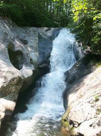
From Ripshin Ridge (NC-181) to Beacon Heights BRP 305.3 The MST passes the highest waterfalls of its entire route on this section as it passes through the scenic and rugged Wilson Creek area. Though not formally designated as a wilderness, parts of the trail will feel wilderness-like and there are some significant stream crossings as well as ridge-top views. Beyond Wilson Creek the trail ascends again to Beacon Heights on the Blue Ridge Parkway.
Intersecting Trails
This trail is located in the Black Mountains & Toe River area. For a list of all the trails in that area, see the Black Mountains & Toe River trails list page.
This trail also crosses into these trailhead areas:
All Photos from the Trail


GPS Map
Map Information
Download GPS Data
Click on a route, trail, or point on the map and select the GPS Data tab to download its data.
Data Formats
KML (Google Earth)
KML is the main file type used by Google Earth. If you have Google Earth installed, clicking the KML link should open the trail or point directly in Google Earth for viewing. This is the native file format used by Google Earth, but many other map applications can use and understand KML as well, so if you're not sure which one to download, KML is a good bet.
GPX
The GPX format stands for GPS Exchange - a free, open, XML format for exchanging GPS and map data. GPX is compatible with Google Earth, many other mapping programs, and most GPS devices (such as Garmin). Load the file directly into your GPS to help find your way on your next trip!
GeoJSON
GeoJSON is a newer, lightweight data exchange format which can be used to quickly share map data and may have a smaller size than KML or GPX. Many professional mapping and GIS applications support the GeoJSON format.
About the Map
Copyright
Base Layers
Base layers provided by OpenStreetMap, the US Geological Survey, the US Forest Service, and NC OneMap. Base layer images are subject to the respective copyright policies of their owners. Base layers may not be available at all times due to system maintenance or outages.
WNCOutdoors Base Layer
The WNCOutdoors Base layer is provided by WNCOutdoors.info. It is licensed by Creative Commons Attribution 3.0.
Trail and Marker Overlays
Trail layers and downloadable data are all original works created by WNCOutdoors with guidance from a variety of sources, including ensembles of our own GPS tracks, user contributed GPS tracks, official maps and GIS data from government agencies, and field observations. WNCOutdoors data is made freely available under the Open Database License - you are free to copy and use it for any purpose under the terms of that license (summary).
Tips
- Hover over a trail to see it highlighted. Helps to see start and end points for an individual trail.
- Scroll and zoom the map before printing, and that view will persist into the printed image.
- Click a trail for more details and to download it individually.
Trail Segments
Trails are often made up of several connecting paths which may have different characteristics, allowed uses, and seasons. This trail is divided into multiple segments as follows:
Mountains to Sea Trail - River Loop to FS 2074
- Allowed Uses: Hiking
- Length: 1.5 mi
Mountains to Sea Trail - FS 2074 to Road
- Allowed Uses: Hiking
- Length: 0.2 mi
Mountains to Sea Trail - Road to Parkway (Black Mtns.)
- Allowed Uses: Hiking
- Length: 3.13 mi
Mountains to Sea Trail - Black Mountains - to Singecat Ridge Overlook
- Allowed Uses: Hiking
- Length: 0.56 mi
Mountains to Sea Trail - Black Mountains - Singecat Ridge Overlook to NC 80
- Allowed Uses: Hiking
- Length: 1.45 mi
Mountains to Sea Trail - NC 80 to Hazelnut Gap
- Allowed Uses: Hiking
- Length: 0.61 mi
Mountains to Sea Trail - Armstrong Creek Trail to Bad Fork Trail
- Allowed Uses: Hiking
- Length: 3.04 mi
Mountains to Sea Trail - Bad Fork Trail to Woodlawn
- Allowed Uses: Hiking
- Length: 8.08 mi
Mountains to Sea Trail - Woodlawn to Catawba River Bridge
- Allowed Uses: Hiking
- Length: 3.84 mi
Mountains to Sea Trail - Catawba River Bridge to Bald Knob
- Allowed Uses: Hiking
- Length: 3.87 mi
Mountains to Sea Trail - Bald Knob to
- Allowed Uses: Hiking
- Length: 4.6 mi
Mountains to Sea Trail - Overmountain Victory - Linville
- Allowed Uses: Hiking
- Length: 1.47 mi
Mountains to Sea Trail - Kistler - Old NC 105
- Allowed Uses: Hiking
- Length: 0.75 mi
Mountains to Sea - Linville Gorge - Kistler to Leadmine Ext.
- Allowed Uses: Hiking
- Length: 1.07 mi
Mountains to Sea - Linville - Leadmin Ext. to FS 117 Conn.
- Allowed Uses: Hiking
- Length: 0.24 mi
Mountains to Sea - Linville - FS 117 Conn. to Bottom trk.
- Allowed Uses: Hiking
- Length: 1.36 mi
Mountains to Sea - Linville - Bottom Trk. to River
- Allowed Uses: Hiking
- Length: 0.19 mi
Mountains to Sea - Linville - River to Blue Dot Access
- Allowed Uses: Hiking
- Length: 0.27 mi
Mountains to Sea - Linville - Blue Dot Access to Rick's Crossover
- Allowed Uses: Hiking
- Length: 0.99 mi
Mountains to Sea - Linville - Rick's Crossover to Wolf Pit
- Allowed Uses: Hiking
- Length: 0.24 mi
Mountains to Sea - Linville - Wolf Pit to Olson
- Allowed Uses: Hiking
- Length: 55 ft
Mountains to Sea - Linville - Olson to Jeep Trail
- Allowed Uses: Hiking
- Length: 0.76 mi
Mountains to Sea - Linville - Jeep Trail to Shortoff Overlook
- Allowed Uses: Hiking
- Length: 0.44 mi
Mountains to Sea - Linville - Shortoff Overlook
- Allowed Uses: Hiking
- Length: 263 ft
Mountains to Sea - Linville - Shortoff Overlook to Cambric Tr.
- Allowed Uses: Hiking
- Length: 2.53 mi
Mountains to Sea - Linville - Cambric to Chimney Gap Water
- Allowed Uses: Hiking
- Length: 0.3 mi
Mountains to Sea - Linville - Chimney Gap Water Tr. to Gap Connector
- Allowed Uses: Hiking
- Length: 0.38 mi
Mountains to Sea - Linville - Gap Connector to Amphitheater
- Allowed Uses: Hiking
- Length: 0.55 mi
Mountains to Sea - Linville - Amphitheater to Mossy Monster
- Allowed Uses: Hiking
- Length: 0.3 mi
Mountains to Sea - Linville - Mossy Monster to Camel
- Allowed Uses: Hiking
- Length: 323 ft
Mountains to Sea - Linville - Chimneys to Table Rock Parking
- Allowed Uses: Hiking
- Length: 0.77 mi
Table Rock Summit - Parking to Little Table Rock Tr.
- Allowed Uses: Hiking
- Length: 0.3 mi
Table Rock Summit - Little Table Rock Tr. to MST
- Allowed Uses: Hiking
- Length: 299 ft
Mountains to Sea Trail - Table Rock Tr. to Roses Creek Rd.
- Allowed Uses: Hiking
- Length: 1.02 mi
Mountains to Sea Trail - along Roses Creek Rd.
- Allowed Uses: Hiking
- Length: 316 ft
Mountains to Sea Trail - Roses Creek Road to New Gingercake Road
- Allowed Uses: Hiking
- Length: 0.36 mi
Mountains to Sea Trail - along New Gingercake Road
- Allowed Uses: Hiking
- Length: 0.18 mi
Mountains to Sea Trail - New Gingercake Road to Steeles Creek
- Allowed Uses: Hiking
- Length: 5.44 mi
MST Section 4 - Steeles Creek
- Allowed Uses: Hiking
- Length: 0.67 mi
Mountains to Sea Trail - Steeles Creek to NC 181
- Allowed Uses: Hiking
- Length: 0.91 mi
MST Section 4 - NC 181 to Greentown Shortcut
- Allowed Uses: Hiking
- Length: 1.81 mi
MST Section 4 - Greentown Shortcut to Raider Camp
- Allowed Uses: Hiking
- Length: 3.71 mi
Raider Camp - S. Harper Ck Falls Overlook to MTS
- Allowed Uses: Hiking
- Length: 335 ft
Raider Camp - Harper Creek to Pine Ridge Tr.
- Allowed Uses: Hiking
- Length: 0.32 mi
Harper Creek - Raider Camp to Harper Creek Falls
- Allowed Uses: Hiking
- Length: 0.35 mi
Harper Creek - Harper Creek Falls to Harper Ck. Tr.
- Allowed Uses: Hiking
- Length: 1.73 mi
North Harper Creek - Harper Creek to Persimmon Ridge
- Allowed Uses: Hiking
- Length: 0.8 mi
North Harper Creek - Persimmon Ridge Tr. to Bard Falls
- Allowed Uses: Hiking
- Length: 0.55 mi
North Harper Creek - Bard Falls to N. Harper Shortcut
- Allowed Uses: Hiking
- Length: 0.65 mi
North Harper Shortcut
- Allowed Uses: Hiking
- Length: 1 mi
Mountains to Sea Trail - Hazelnut Gap to Armstrong Creek Trail
- Allowed Uses: Hiking
- Length: 0.22 mi
Total Calculated Length: 63.84 mi
This value is derived from our underlying map data, and it may not match officially published information.
Feedback
Ratings
Average Rating: (rated 0 times)
Rate It Now:

No comments yet.