Bear Pen Trail

At A Glance


1.4 mi one-way
Difficulty Rating: 2.84 ![]()
Steepness: Climbs Steeply ![]()
Tread Condition: Moderately Rough ![]()
Lowest Elevation: 3930 ft
Highest Elevation: 4600 ft
Climb Total: 670 ft
Blaze Color: Orange
Trail Number: 176
Description
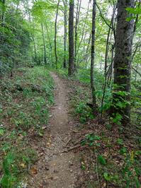
Starting on FS 74, this trail climbs old road beds up to the Laurel Gap trail (another, newer logging road). Beginning as a wide, eroded trough climbing through a gentle cove of mixed hardwoods, the trail climbs past the 4000 ft elevation contour near a switchback from north to southeast. It then ascends Walker Ridge sidelong on a prettier section of trail toward a conjunction with Staire Branch, where it crosses a northern and southern fork of that stream. The trail then climbs the next ridge south, unnamed, before wrapping around its nose for the final push to the top in an area where some large Eastern Hemlock trees still survive as of September 2019. The trail then passes into the lower elevations of the Northern Hardwood forest zone before ending.
A little overgrown with weeds in places, and there's lots of stinging nettle, so be sure to wear long pants on this trail (and others in the area). Old logging roads go off in all directions from this one but the correct route is fairly well-worn and obvious. Do pay attention if you get to what looks to be a junction since there are no signs or blazes.
Intersecting Trails
This trail is located in the Big Ivy (Coleman Boundary) area. For a list of all the trails in that area, see the Big Ivy (Coleman Boundary) trails list page.
All Photos from the Trail


GPS Map
Map Information
Download GPS Data
Click on a route, trail, or point on the map and select the GPS Data tab to download its data.
Data Formats
KML (Google Earth)
KML is the main file type used by Google Earth. If you have Google Earth installed, clicking the KML link should open the trail or point directly in Google Earth for viewing. This is the native file format used by Google Earth, but many other map applications can use and understand KML as well, so if you're not sure which one to download, KML is a good bet.
GPX
The GPX format stands for GPS Exchange - a free, open, XML format for exchanging GPS and map data. GPX is compatible with Google Earth, many other mapping programs, and most GPS devices (such as Garmin). Load the file directly into your GPS to help find your way on your next trip!
GeoJSON
GeoJSON is a newer, lightweight data exchange format which can be used to quickly share map data and may have a smaller size than KML or GPX. Many professional mapping and GIS applications support the GeoJSON format.
About the Map
Copyright
Base Layers
Base layers provided by OpenStreetMap, the US Geological Survey, the US Forest Service, and NC OneMap. Base layer images are subject to the respective copyright policies of their owners. Base layers may not be available at all times due to system maintenance or outages.
WNCOutdoors Base Layer
The WNCOutdoors Base layer is provided by WNCOutdoors.info. It is licensed by Creative Commons Attribution 3.0.
Trail and Marker Overlays
Trail layers and downloadable data are all original works created by WNCOutdoors with guidance from a variety of sources, including ensembles of our own GPS tracks, user contributed GPS tracks, official maps and GIS data from government agencies, and field observations. WNCOutdoors data is made freely available under the Open Database License - you are free to copy and use it for any purpose under the terms of that license (summary).
Tips
- Hover over a trail to see it highlighted. Helps to see start and end points for an individual trail.
- Scroll and zoom the map before printing, and that view will persist into the printed image.
- Click a trail for more details and to download it individually.
Feedback
Ratings
Average Rating: 4.0 (rated 2 times)
Rate It Now:

Susan said: Attractive western views around 4 - 8p 5/28. Broad biked out? tread first 1/2 mile. Levels off to some pleasant moss/grass sided areas. 4 slight water crossings. Honestly, does no one know the 'rule' about steep? THESE trails are not steep. 'Steep' is elevation gain over 1000' per mile. This is 570' over 1.4. Generously call it 200' per 1/2 mile. Walk in park.
Lee said: You better be in shape for this trail as it is deceptively steep and will wind you if you are not in good shape!