Staire Creek Trail

At A Glance


1.1 mi one-way
Difficulty Rating: 1.1 ![]()
Steepness: Climbs Steeply ![]()
Tread Condition: Some Obstacles ![]()
Blaze Color: Orange
Trail Number: 183
Description
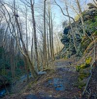
Steep climb or descent mostly on eroded old roadbeds. Follows creek near the bottom; ascends to ridge near the top where it flattens out and passes through a clearing before ending on FS 74. Passes through a nice mature hardwood forest with a smattering of rhododendron in the lower sections. There are some cliffs & small rock caves along the trail - at one point the rushing water can be heard in stereo as it bounces off a rock face.
Intersecting Trails
This trail is located in the Big Ivy (Coleman Boundary) area. For a list of all the trails in that area, see the Big Ivy (Coleman Boundary) trails list page.
All Photos from the Trail


GPS Map
Map Information
Download GPS Data
Click on a route, trail, or point on the map and select the GPS Data tab to download its data.
Data Formats
KML (Google Earth)
KML is the main file type used by Google Earth. If you have Google Earth installed, clicking the KML link should open the trail or point directly in Google Earth for viewing. This is the native file format used by Google Earth, but many other map applications can use and understand KML as well, so if you're not sure which one to download, KML is a good bet.
GPX
The GPX format stands for GPS Exchange - a free, open, XML format for exchanging GPS and map data. GPX is compatible with Google Earth, many other mapping programs, and most GPS devices (such as Garmin). Load the file directly into your GPS to help find your way on your next trip!
GeoJSON
GeoJSON is a newer, lightweight data exchange format which can be used to quickly share map data and may have a smaller size than KML or GPX. Many professional mapping and GIS applications support the GeoJSON format.
About the Map
Copyright
Base Layers
Base layers provided by OpenStreetMap, the US Geological Survey, the US Forest Service, and NC OneMap. Base layer images are subject to the respective copyright policies of their owners. Base layers may not be available at all times due to system maintenance or outages.
WNCOutdoors Base Layer
The WNCOutdoors Base layer is provided by WNCOutdoors.info. It is licensed by Creative Commons Attribution 3.0.
Trail and Marker Overlays
Trail layers and downloadable data are all original works created by WNCOutdoors with guidance from a variety of sources, including ensembles of our own GPS tracks, user contributed GPS tracks, official maps and GIS data from government agencies, and field observations. WNCOutdoors data is made freely available under the Open Database License - you are free to copy and use it for any purpose under the terms of that license (summary).
Tips
- Hover over a trail to see it highlighted. Helps to see start and end points for an individual trail.
- Scroll and zoom the map before printing, and that view will persist into the printed image.
- Click a trail for more details and to download it individually.
Feedback
Ratings
Average Rating: 4.5 (rated 2 times)
Rate It Now:

Tyler K. said: This is a lovely little trail to take your time and soak in the good vibes down by creek. Staire creek is gently cascading over rounded mossy rocks and is lined with rhododendron and mountain dog hobble. There are lots of interesting eddies and pools to explore for aquatic life. About 1/2-3/4 of a mile in you get to a cool cave, which is apparently a climbing spot (chalk marks on holds) which has some sweet rock furniture and fire pit that someone made. There is a geocache there (make sure to leave a note) full of inspiration. Sadly, in the forest of this area, you can see the devastation left by the hemlock wooly adelgid, but you can also see the understory transitioning into heath shrubs, which is kind of neat. The trail past the cave becomes very very steep and tiring, so I opted to not go any further, however I was very pleased to spend an hour or so hanging out in the creek. If you are looking to put some miles in on a hike, this isn't the greatest trail for you (unless you connect to other trails) but it is well worth a walk because it is a beautiful rich cove. Plan your hike accordingly because it gets dark and very cool down in this holler earlier than other places. Maybe I'll see you there!