Snowball Trail

At A Glance


3 mi one-way
Difficulty Rating: 7.2 ![]()
Steepness: Hilly ![]()
Tread Condition: Moderately Rough ![]()
Lowest Elevation: 4360 ft
Highest Elevation: 5380 ft
Climb Total: 2040 ft
Blaze Color: White
Trail Number: 170
Hikes That Use This Trail: Snowball
Description
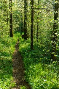
From the intersection of Stoney Fork Road and the Craggy Gardens Picnic Area access road in Beetree Gap, the Mountains to Sea Trail climbs past a nice clearing to a junction with the Snowball trail on the right. The Snowball trail slips off the north side of the ridge and makes a few switchbacks as it climbs through a beautiful northern hardwood forest toward the summit, a forest with some big old oaks in it. There are patches of spruce-fir forest, too, which are unusual for the Craggies.
Crosses the summit of 5,341 ft Snowball Mountain in an areas where the ridge drops steeply on both sides of the trail. Winds downhill on the other side of the summit to a gap, then climbs again to Hawkbill Rock, where the trail becomes steep and rough. On Hawkbill Rock, there are limited views mostly to the southeast back toward Snowball Mountain and Lane Pinnacle, but also to the west toward the Craggies.
The trail continues to follow the ridge toward Snowball Gap, a drop of 800 ft from the top of the ridge near Hawkbill, but with some uphill sections along the way, too.
The trail widens at Snowball Gap due to illegal ATV use and begins to climb toward Little Snowball Mountain. There are some downhill spots, though, which will be uphill on the way back. On Little Snowball, you may spot the remains of the old fire lookout tower that once stood on the summit. It was relocated to the Big Ivy Historical Park years ago, and only the concrete foundation remains.
The hike back is more of a climb than a descent, so factor that in when deciding how much of this trail to hike. A great out-and-back destination using this trail is Hawkbill Rock (2.75 mi round-trip), since that covers the most interesting parts of the trail. See the Snowball Hike for more details.
Intersecting Trails
This trail is located in the Blue Ridge Parkway Section 4 area. For a list of all the trails in that area, see the Blue Ridge Parkway Section 4 trails list page.
This trail also crosses into these trailhead areas:
All Photos from the Trail


GPS Map
Map Information
Download GPS Data
Click on a route, trail, or point on the map and select the GPS Data tab to download its data.
Data Formats
KML (Google Earth)
KML is the main file type used by Google Earth. If you have Google Earth installed, clicking the KML link should open the trail or point directly in Google Earth for viewing. This is the native file format used by Google Earth, but many other map applications can use and understand KML as well, so if you're not sure which one to download, KML is a good bet.
GPX
The GPX format stands for GPS Exchange - a free, open, XML format for exchanging GPS and map data. GPX is compatible with Google Earth, many other mapping programs, and most GPS devices (such as Garmin). Load the file directly into your GPS to help find your way on your next trip!
GeoJSON
GeoJSON is a newer, lightweight data exchange format which can be used to quickly share map data and may have a smaller size than KML or GPX. Many professional mapping and GIS applications support the GeoJSON format.
About the Map
Copyright
Base Layers
Base layers provided by OpenStreetMap, the US Geological Survey, the US Forest Service, and NC OneMap. Base layer images are subject to the respective copyright policies of their owners. Base layers may not be available at all times due to system maintenance or outages.
WNCOutdoors Base Layer
The WNCOutdoors Base layer is provided by WNCOutdoors.info. It is licensed by Creative Commons Attribution 3.0.
Trail and Marker Overlays
Trail layers and downloadable data are all original works created by WNCOutdoors with guidance from a variety of sources, including ensembles of our own GPS tracks, user contributed GPS tracks, official maps and GIS data from government agencies, and field observations. WNCOutdoors data is made freely available under the Open Database License - you are free to copy and use it for any purpose under the terms of that license (summary).
Tips
- Hover over a trail to see it highlighted. Helps to see start and end points for an individual trail.
- Scroll and zoom the map before printing, and that view will persist into the printed image.
- Click a trail for more details and to download it individually.
Trail Segments
Trails are often made up of several connecting paths which may have different characteristics, allowed uses, and seasons. This trail is divided into multiple segments as follows:
Snowball - MST to Hawkbill Rock
- Allowed Uses: Hiking
- Length: 1.27 mi
Snowball - Hawkbill Rock to Snowball Gap
- Allowed Uses: Hiking
- Length: 1.1 mi
Snowball Trail - Snowball Gap to Little Snowball Mtn
- Allowed Uses: Hiking
- Length: 1.03 mi
Snowball Trail - to Little Snowball Summit
- Allowed Uses: Hiking
- Length: 134 ft
Total Calculated Length: 3.43 mi
This value is derived from our underlying map data, and it may not match officially published information.
Feedback
Ratings
Average Rating: 4.0 (rated 3 times)
Rate It Now:

AKACAK said: Hiked today (7/24/17). Trail is in good condition. We had a plethora of butterflies and breezes. Fading rhododendrons and abundant Turk Caps dominated most of the color-scape. This has got to be a grand hike in the fall/winter when the trees have shed. We Will certainly return.