Hiking in the Craggy Gardens Area
Craggy Gardens is a mountaintop area located along the Blue Ridge Parkway not far north of Asheville, NC in the Great Craggy Mountains range.

Peaks top out at over 6000 ft in elevation, while the Parkway in this area ranges from about 4600 ft to 5600 ft, making it one of the high altitude areas to escape the summer heat and enjoy early fall color. A number of trails wind throughout the area with the Mountains to Sea Trail as a backbone linking them together. Everything from short, easy strolls to long, overnight hikes are possible starting from Craggy Gardens, with gorgeous scenery making it all worth the effort.

Hiking Trails
The Craggy Gardens trail connects the Visitor Center with the Picnic Area, sharing a portion of the path with the Mountains to Sea Trail. It's a moderate hike, with a spur trail at the high point that leads to the gardens area and an overlook. The trail is extremely popular, but highly recommended, and is one of the best hikes in the region.
The Craggy Pinnacle trail starts one parking area north of the Visitor Center, at the Craggy Dome overlook. It's short, but it leads to one of the best summit views in the range as it reaches the very top of this sharp-peaked mountain. This trail does not connect to the others in the area without a walk on the Parkway.
The Snowball trail is a US Forest Service trail which starts off the Mountains to Sea Trail just west of the visitor center. It leads across Snowball Mountain to Hawkbill Rock, where a great view back to the east of the primary ridge of the Great Craggy range. A lesser-used trail, it's most easily accessed from the first junction on the Picnic Area spur road, or from the Picnic Area itself, but it can also be accessed from the visitor center via the Craggy Gardens trail.
The Douglas Falls trail is a US Forest Service trail which connects to the Mountain to Sea Trail on Craggy Pinncale. It's accessible from the visitor center parking area, and descends 3.5 mi to the 70-ft free-falling waterfall of the same name. This is a more strenuous trek with over 1500 ft of elevation gain; however, it travels through a beautiful, wilderness-like area and is well worth the effort if you have the time and energy.
The Mountains to Sea Trail passes through the entire Craggy Gardens area, sharing a portion of path with the Craggy Gardens trail. It can be used to tie all the other trails in the Craggy Gardens area together.
Craggy Gardens Trail


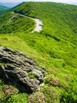
Craggy Pinnacle Trail
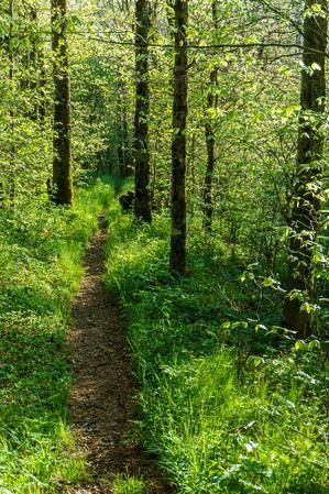
Snowball Trail

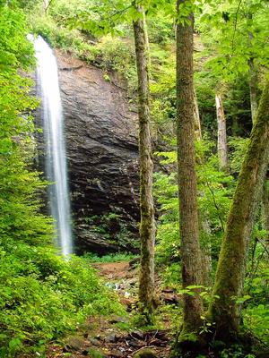
Douglas Falls Trail
Mountains to Sea Section 3 Trail

Map Information
Download GPS Data
Click on a route, trail, or point on the map and select the GPS Data tab to download its data.
Data Formats
KML (Google Earth)
KML is the main file type used by Google Earth. If you have Google Earth installed, clicking the KML link should open the trail or point directly in Google Earth for viewing. This is the native file format used by Google Earth, but many other map applications can use and understand KML as well, so if you're not sure which one to download, KML is a good bet.
GPX
The GPX format stands for GPS Exchange - a free, open, XML format for exchanging GPS and map data. GPX is compatible with Google Earth, many other mapping programs, and most GPS devices (such as Garmin). Load the file directly into your GPS to help find your way on your next trip!
GeoJSON
GeoJSON is a newer, lightweight data exchange format which can be used to quickly share map data and may have a smaller size than KML or GPX. Many professional mapping and GIS applications support the GeoJSON format.
About the Map
Copyright
Base Layers
Base layers provided by OpenStreetMap, the US Geological Survey, the US Forest Service, and NC OneMap. Base layer images are subject to the respective copyright policies of their owners. Base layers may not be available at all times due to system maintenance or outages.
WNCOutdoors Base Layer
The WNCOutdoors Base layer is provided by WNCOutdoors.info. It is licensed by Creative Commons Attribution 3.0.
Trail and Marker Overlays
Trail layers and downloadable data are all original works created by WNCOutdoors with guidance from a variety of sources, including ensembles of our own GPS tracks, user contributed GPS tracks, official maps and GIS data from government agencies, and field observations. WNCOutdoors data is made freely available under the Open Database License - you are free to copy and use it for any purpose under the terms of that license (summary).
Tips
- Hover over a trail to see it highlighted. Helps to see start and end points for an individual trail.
- Scroll and zoom the map before printing, and that view will persist into the printed image.
- Click a trail for more details and to download it individually.
Facilities
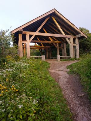
Picnic Area
The Craggy Gardens picnic area offers a mountaintop setting with a good number of tables on a hilly site. Wheelchair-accessible restrooms with flush toilets, water, tables, fire rings, and grills are available at the picnic area in a mixture of open and shady sites. The Craggy Gardens trail starts within the picnic area and the Mountains to Sea Trail runs through it as well, meaning you can start your hike directly from the picnic area.
Visitor Center
The Craggy Gardens visitor center, open from May - October, has some exhibits on the flora, fauna and geology of the area, as well as a small Parkway store with books, maps, and local art. Stop in for a warm-up on a cold day or to sit a spell and look out at the view. Restrooms are available under the visitor center building, but they are not wheelchair-accessible.
Directions
Craggy Gardens is located about 15 miles north of Asheville on the Blue Ridge Parkway (from the Folk Art Center at US 70). Look for the mileposts to find the most popular stopping points:
- 367.6 for the Craggy Gardens Picnic Area and trails, and the Snowball trail
- 364.4 for the Visitor Center and Craggy Gardens trail
- 364.1 for the Craggy Pinnacle trail (at the Craggy Dome overlook).
