North Slope Trail

At A Glance


")
3.7 mi one-way
Difficulty Rating: 4.95 ![]()
Steepness: Hilly ![]()
Tread Condition: Some Obstacles ![]()
Lowest Elevation: 2150 ft
Highest Elevation: 2550 ft
Climb Total: 500 ft
Blaze Color: Orange
Trail Number: 359
Description
This neat little loop starts and ends in the Davidson River campground, making it a must-hike if you're staying there. Described counterclockwise, but can be hiked in either direction.
Starting at the campground's amphitheater, the trail climbs an out-and-back portion to a split; turn right. The trail circumnavigates the campground near the bottom of the ridge, then joins with the Seely Memorial Trail. It reaches a junction with the Exercise trail; turn left to begin following the Davidson River upstream.
The trail then pulls away from the river, steepens, goes 'round a ridge, and follows smaller stream up through a shallow cove.
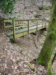
At the junction with North Slope Connector, turn left to stay on North Slope. The trail levels out and starts traversing North Slope Ridge in a sidehill fashion. It dips into small coves goes out around little ridges. There is one interesting bridge over a deep gully, and there are a couple of smaller log bridges.
The forest is mostly mixed hardwoods; Hemlock groves in this area are mostly dead due to Hemlock Woolly Adelged infestation. There are some neat mountain laurel and rhododendron tunnels.
The trail then descends moderately again to the amphitheater and campground.
Intersecting Trails
This trail is located in the Davidson River area. For a list of all the trails in that area, see the Davidson River trails list page.
All Photos from the Trail


GPS Map
Map Information
Download GPS Data
Click on a route, trail, or point on the map and select the GPS Data tab to download its data.
Data Formats
KML (Google Earth)
KML is the main file type used by Google Earth. If you have Google Earth installed, clicking the KML link should open the trail or point directly in Google Earth for viewing. This is the native file format used by Google Earth, but many other map applications can use and understand KML as well, so if you're not sure which one to download, KML is a good bet.
GPX
The GPX format stands for GPS Exchange - a free, open, XML format for exchanging GPS and map data. GPX is compatible with Google Earth, many other mapping programs, and most GPS devices (such as Garmin). Load the file directly into your GPS to help find your way on your next trip!
GeoJSON
GeoJSON is a newer, lightweight data exchange format which can be used to quickly share map data and may have a smaller size than KML or GPX. Many professional mapping and GIS applications support the GeoJSON format.
About the Map
Copyright
Base Layers
Base layers provided by OpenStreetMap, the US Geological Survey, the US Forest Service, and NC OneMap. Base layer images are subject to the respective copyright policies of their owners. Base layers may not be available at all times due to system maintenance or outages.
WNCOutdoors Base Layer
The WNCOutdoors Base layer is provided by WNCOutdoors.info. It is licensed by Creative Commons Attribution 3.0.
Trail and Marker Overlays
Trail layers and downloadable data are all original works created by WNCOutdoors with guidance from a variety of sources, including ensembles of our own GPS tracks, user contributed GPS tracks, official maps and GIS data from government agencies, and field observations. WNCOutdoors data is made freely available under the Open Database License - you are free to copy and use it for any purpose under the terms of that license (summary).
Tips
- Hover over a trail to see it highlighted. Helps to see start and end points for an individual trail.
- Scroll and zoom the map before printing, and that view will persist into the printed image.
- Click a trail for more details and to download it individually.
Trail Segments
Trails are often made up of several connecting paths which may have different characteristics, allowed uses, and seasons. This trail is divided into multiple segments as follows:
North Slope - Amphitheater Parking to Junction
- Allowed Uses: Hiking, Mountain Biking
- Length: 0.17 mi
North Slope - Junction to Seely Memorial Tr.
- Allowed Uses: Hiking, Mountain Biking
- Length: 0.54 mi
North Slope - North Slope Connector to Junction
- Allowed Uses: Hiking, Mountain Biking
- Length: 1.85 mi
North Slope - Exercise Trail to North Slope Connector
- Allowed Uses: Hiking, Mountain Biking
- Length: 1.14 mi
North Slope - Seely Memorial Trail to Exercise Trail
- Allowed Uses: Hiking, Mountain Biking
- Length: 0.24 mi
Total Calculated Length: 3.95 mi
This value is derived from our underlying map data, and it may not match officially published information.
Feedback
Ratings
Average Rating: 3.6 (rated 14 times)
Rate It Now:

MARITA LITTLEJOHN said: I am new to biking do you have a schedule showing the times and dates that you all meet to ride? Please let me know at your earliest convience. Marita L. 828-490-3957