High Falls Trail

At A Glance


0.73 mi one-way
Difficulty Rating: 0.73 ![]()
Steepness: Climbs Moderately ![]()
Tread Condition: Some Obstacles ![]()
Hikes That Use This Trail: Dupont Waterfalls and Lakes Tour
Description
This "trail" has a several different parts to it. Starting at the High Falls parking area, a new section of footpath parallels Buck Forest Road and leads to the south intersection with the Triple Falls trail near the covered bridge. It's nice because it keeps you from having to walk on the boring, open, sunny portion Buck Forest Road. (Bikers and horses still use that portion of the road). This path is hard-packed and smooth, and is open to hikers only (and is wheelchair accessible). This path has one neat, sturdy footbridge that kids will love.
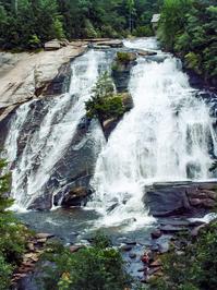
At the Triple Falls trail intersection, High Falls Trail continues straight on an old gravel road. It passes the Covered Bridge trail on the right, and descends a short distance to a split. The left fork is mostly level, and goes to the picnic shelter and a great view of the falls. This is the easiest way to the falls overlook.
The right fork gets narrower and descends steeply, past the lower overlook of the falls. (A short path also connects the picnic shelter to this lower overlook). Below the lower overlook, the trail continues descending steeply to the river and joins the River Bend trail on the right. (That's the way to the base of the falls.) Then it curves left and becomes a rocky old roadbed. It follows a tranquil section of the Little River on a gentle grade downstream, before climbing just a bit up to its end at the north intersection with the Triple Falls trail.
Triple Falls is about 100 feet downhill from the last junction, and you can use that trail to make a nice, short loop hike which includes High and Triple Falls.
Intersecting Trails
This trail is located in the Dupont State Forest area. For a list of all the trails in that area, see the Dupont State Forest trails list page.
All Photos from the Trail


GPS Map
Map Information
Download GPS Data
Click on a route, trail, or point on the map and select the GPS Data tab to download its data.
Data Formats
KML (Google Earth)
KML is the main file type used by Google Earth. If you have Google Earth installed, clicking the KML link should open the trail or point directly in Google Earth for viewing. This is the native file format used by Google Earth, but many other map applications can use and understand KML as well, so if you're not sure which one to download, KML is a good bet.
GPX
The GPX format stands for GPS Exchange - a free, open, XML format for exchanging GPS and map data. GPX is compatible with Google Earth, many other mapping programs, and most GPS devices (such as Garmin). Load the file directly into your GPS to help find your way on your next trip!
GeoJSON
GeoJSON is a newer, lightweight data exchange format which can be used to quickly share map data and may have a smaller size than KML or GPX. Many professional mapping and GIS applications support the GeoJSON format.
About the Map
Copyright
Base Layers
Base layers provided by OpenStreetMap, the US Geological Survey, the US Forest Service, and NC OneMap. Base layer images are subject to the respective copyright policies of their owners. Base layers may not be available at all times due to system maintenance or outages.
WNCOutdoors Base Layer
The WNCOutdoors Base layer is provided by WNCOutdoors.info. It is licensed by Creative Commons Attribution 3.0.
Trail and Marker Overlays
Trail layers and downloadable data are all original works created by WNCOutdoors with guidance from a variety of sources, including ensembles of our own GPS tracks, user contributed GPS tracks, official maps and GIS data from government agencies, and field observations. WNCOutdoors data is made freely available under the Open Database License - you are free to copy and use it for any purpose under the terms of that license (summary).
Tips
- Hover over a trail to see it highlighted. Helps to see start and end points for an individual trail.
- Scroll and zoom the map before printing, and that view will persist into the printed image.
- Click a trail for more details and to download it individually.
Trail Segments
Trails are often made up of several connecting paths which may have different characteristics, allowed uses, and seasons. This trail is divided into multiple segments as follows:
Triple Falls Tr. to River Bend Tr.
- Allowed Uses: Hiking, Mountain Biking, Horseback Riding
- Length: 0.32 mi
High Falls Parking to Triple Falls Shortcut
- Allowed Uses: Hiking, Accessible
- Length: 0.21 mi
Triple Falls Shortcut to Triple Falls Tr.
- Allowed Uses: Hiking, Accessible
- Length: 0.13 mi
High Falls Tr. to Triple Falls Tr.
- Allowed Uses: Hiking
- Length: 382 ft
Picnic Shelter to Lower Overlook
- Allowed Uses: Hiking
- Length: 364 ft
River Bend Tr. to High Falls Overlook
- Allowed Uses: Hiking, Mountain Biking, Horseback Riding
- Length: 0.21 mi
High Falls Overlook to Picnic Shelter Road
- Allowed Uses: Hiking, Mountain Biking, Horseback Riding
- Length: 0.1 mi
Picnic Shelter Spur Rd. to Covered Bridge Tr.
- Allowed Uses: Hiking, Mountain Biking, Horseback Riding
- Length: 282 ft
Covered Bridge Tr. to Triple Falls Tr.
- Allowed Uses: Hiking, Mountain Biking, Horseback Riding
- Length: 191 ft
One End of the Picnic Shelter to The Other
- Allowed Uses: Hiking
- Length: 102 ft
High Falls Tr. to Picnic Shelter
- Allowed Uses: Hiking, Mountain Biking, Horseback Riding
- Length: 456 ft
Total Calculated Length: 1.3 mi
This value is derived from our underlying map data, and it may not match officially published information.
Feedback
Ratings
Average Rating: (rated 0 times)
Rate It Now:

No comments yet.