Summit Trail

At A Glance


1.8 mi one-way
Difficulty Rating: 1.8 ![]()
Steepness: Climbs Moderately ![]()
Tread Condition: Some Obstacles ![]()
Blaze Color: Blue
Description
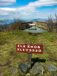
Climbs from the parking area to the summit, thru switchbacks as it goes. Crosses over an old road (which used to be the main route to the summit) several times on the way. Travels through a northern hardwood forest, which is open and attractive; near the top, the trees turn into miniature versions of the ones lower down the mountain, barely more than head-high. Carpets of wildflowers blanket the slopes in early spring. There's no real water to speak of except possibly one tiny tributary crossing after sustained heavy rains. There are some limited (especially wintertime) views on the way up; the view from the top is spectacular and there are two main overlooks: one facing north, and one facing south.
Peaks visible from the summit include The Peak, Three Top and Bluff Mountains, Mount Jefferson, Grandfather Mountain, Mount Mitchell, Mt Rogers (VA), and the Iron Mountains in Virginia and Tennessee.
This trail is located in the Elk Knob State Park area. For a list of all the trails in that area, see the Elk Knob State Park trails list page.
All Photos from the Trail


GPS Map
Map Information
Download GPS Data
Click on a route, trail, or point on the map and select the GPS Data tab to download its data.
Data Formats
KML (Google Earth)
KML is the main file type used by Google Earth. If you have Google Earth installed, clicking the KML link should open the trail or point directly in Google Earth for viewing. This is the native file format used by Google Earth, but many other map applications can use and understand KML as well, so if you're not sure which one to download, KML is a good bet.
GPX
The GPX format stands for GPS Exchange - a free, open, XML format for exchanging GPS and map data. GPX is compatible with Google Earth, many other mapping programs, and most GPS devices (such as Garmin). Load the file directly into your GPS to help find your way on your next trip!
GeoJSON
GeoJSON is a newer, lightweight data exchange format which can be used to quickly share map data and may have a smaller size than KML or GPX. Many professional mapping and GIS applications support the GeoJSON format.
About the Map
Copyright
Base Layers
Base layers provided by OpenStreetMap, the US Geological Survey, the US Forest Service, and NC OneMap. Base layer images are subject to the respective copyright policies of their owners. Base layers may not be available at all times due to system maintenance or outages.
WNCOutdoors Base Layer
The WNCOutdoors Base layer is provided by WNCOutdoors.info. It is licensed by Creative Commons Attribution 3.0.
Trail and Marker Overlays
Trail layers and downloadable data are all original works created by WNCOutdoors with guidance from a variety of sources, including ensembles of our own GPS tracks, user contributed GPS tracks, official maps and GIS data from government agencies, and field observations. WNCOutdoors data is made freely available under the Open Database License - you are free to copy and use it for any purpose under the terms of that license (summary).
Tips
- Hover over a trail to see it highlighted. Helps to see start and end points for an individual trail.
- Scroll and zoom the map before printing, and that view will persist into the printed image.
- Click a trail for more details and to download it individually.
Feedback
Ratings
Average Rating: 4.0 (rated 3 times)
Rate It Now:

Scout&Rocky said: This a 1.9 mile hike that is clearly marked. The trail is narrow and has switchbacks and resting spots along the trail (use them!). After the first half mile you feel the climb and wonder why everyone coming back shows no sign of the climb. At the 1 mile marker you start hearing others asking how much further to those coming down. This is 1.9 to the top and it's uphill the entire hike. The views at the top are worth it (you can see forever up there) as is coming back down being the rested one seeing others look at you and wonder why you're not tired. :) Yep.. down hill all the way back. The park has a new picnic area and restrooms. Nice park.