Hanging Rock Trail

At A Glance


1.3 mi one-way
Difficulty Rating: 1.3 ![]()
Steepness: Climbs Steeply ![]()
Tread Condition: Some Obstacles ![]()
Blaze Color: Orange
Description
This is the most direct way to reach Hanging Rock itself, and is probably the most popular trail in the park. The trail is wide and has a gravel surface for most of its length, but gets narrower and rockier near the top.
From the picnic area/trailhead parking lot, the trail descends through young woods to become more of a gravel road and cross a small wet-weather stream. It then begins climbing in earnest through a nice mixed forest. After climbing to the ridgeline, the trail undulates and gets a bit narrower as it approaches the southwest face of the rock itself. You'll get some neat views up to the rock from here.
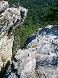
The trail then climbs more steeply again, up some steps, and becomes a narrow path as it begins looping around the southeast side of the rock. There are some neat trees growing up onto the underside of a rock overhang here, appearing like they are supporting the rock. The trail curves back up to the left onto the ridge, then climbs along the ridge to the summit of Hanging Rock, with its magnificent views. Exposed boulders and rock cliffs, along with deep fissures, make it necessary to be careful up here - especially with children. Stunted pines grow along the summit, so shade is sparse - wear sunscreen!
This trail is located in the Hanging Rock State Park area. For a list of all the trails in that area, see the Hanging Rock State Park trails list page.
All Photos from the Trail


Feedback
Ratings
Average Rating: 5.0 (rated 1 times)
Rate It Now:

No comments yet.