Betty Place Trail

At A Glance


1.2 mi one-way
Difficulty Rating: 1.87 ![]()
Steepness: Climbs Moderately ![]()
Tread Condition: Some Obstacles ![]()
Lowest Elevation: 2640 ft
Highest Elevation: 2950 ft
Climb Total: 310 ft
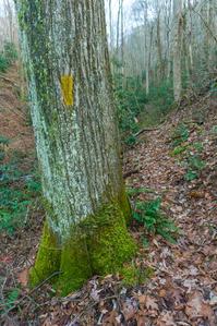
Blaze Color: Yellow
Description
Loop trail winds its way up a lush cove beside the West Fork Shut-In Creek and some of its tributaries. Passes several old homesites in a lush cove with big boulders covered in soft moss. Most of the creek crossings are bridge except the upper crossing of the main stream. You might be able to rock-hop but you might end up with wet feet. Connects with the Bluff Mountain Loop trail to make a longer loop option possible.
Directions
From the junction of NC 209 and US 70 in Hot Springs, NC, take US 70 West for 3 miles to Upper Shut In Rd. Turn left and follow Upper Shut In Rd. for 4.1 miles - this portion is paved. Turn left onto the gravel road at the National Forest sign for the Betty Place Trail. The parking area is just a few yards up the gravel road.
Note: the gravel road may be a little too rough for some passenger cars with very low clearance, but most vehicles should make it OK if you take it slowly.
Intersecting Trails
This trail is located in the Hot Springs area. For a list of all the trails in that area, see the Hot Springs trails list page.
All Photos from the Trail


GPS Map
Map Information
Download GPS Data
Click on a route, trail, or point on the map and select the GPS Data tab to download its data.
Data Formats
KML (Google Earth)
KML is the main file type used by Google Earth. If you have Google Earth installed, clicking the KML link should open the trail or point directly in Google Earth for viewing. This is the native file format used by Google Earth, but many other map applications can use and understand KML as well, so if you're not sure which one to download, KML is a good bet.
GPX
The GPX format stands for GPS Exchange - a free, open, XML format for exchanging GPS and map data. GPX is compatible with Google Earth, many other mapping programs, and most GPS devices (such as Garmin). Load the file directly into your GPS to help find your way on your next trip!
GeoJSON
GeoJSON is a newer, lightweight data exchange format which can be used to quickly share map data and may have a smaller size than KML or GPX. Many professional mapping and GIS applications support the GeoJSON format.
About the Map
Copyright
Base Layers
Base layers provided by OpenStreetMap, the US Geological Survey, the US Forest Service, and NC OneMap. Base layer images are subject to the respective copyright policies of their owners. Base layers may not be available at all times due to system maintenance or outages.
WNCOutdoors Base Layer
The WNCOutdoors Base layer is provided by WNCOutdoors.info. It is licensed by Creative Commons Attribution 3.0.
Trail and Marker Overlays
Trail layers and downloadable data are all original works created by WNCOutdoors with guidance from a variety of sources, including ensembles of our own GPS tracks, user contributed GPS tracks, official maps and GIS data from government agencies, and field observations. WNCOutdoors data is made freely available under the Open Database License - you are free to copy and use it for any purpose under the terms of that license (summary).
Tips
- Hover over a trail to see it highlighted. Helps to see start and end points for an individual trail.
- Scroll and zoom the map before printing, and that view will persist into the printed image.
- Click a trail for more details and to download it individually.
Trail Segments
Trails are often made up of several connecting paths which may have different characteristics, allowed uses, and seasons. This trail is divided into multiple segments as follows:
Bluff Mountain Loop - Betty Place - Parking to Split
- Allowed Uses: Hiking
- Length: 85 ft
Bluff Mountain Loop - Betty Place - West Leg
- Allowed Uses: Hiking
- Length: 0.43 mi
Betty Place - East Leg
- Allowed Uses: Hiking
- Length: 0.58 mi
Total Calculated Length: 1.03 mi
This value is derived from our underlying map data, and it may not match officially published information.
Feedback
Ratings
Average Rating: 3.0 (rated 1 times)
Rate It Now:

Ed said: The Betty Place Trail (named for Betty Gowan whose homestead was located near the trailhead). A 1.2-mile loop crossing a stream a couple of times with nice bridges. It was a little confusing at the start with two trails. We took the one on the right which I now think is the Bluff Mountain Trail. No matter, shortly you will come to a sign directing you to keep right on Bluff Mountain Trail or cross the bridge onto Betty Place Loop. Very easy and fun taking about 45 minutes if you stop and take a few pictures. Bitsy, Daisy (aka Trail Hound) and I hiked it December 19, 2017. We found the old home place though there was nothing there to see. We found a deer carcass that someone has dumped in the trailhead parking lot. Most unusual find was when we drove on up to the end of the gravel road and saw something in the road. After stopping and getting out of the truck we discovered it was a box of Asparagus spears! Yes, you read that correctly. A box apparently from the Farmers Market with several bunches of fresh asparagus spears tucked inside, could not have been more that a day old. We moved the box to the side of the road in case the owner came looking for them. Daisy’s comments: Too short! We did not see another dog or human so I was allowed off leash, which was good. Next time we need to take the Bluff Mountain Trail which is 3.5 miles. My humans were lazy today and just used this hike as an excuse to drink beer and eat pizza. However, I will help them eat the pizza at the Spring Creek Tavern.