Laurel River Trail

At A Glance


3.6 mi one-way
Difficulty Rating: 3.6 ![]()
Steepness: Climbs Gently ![]()
Tread Condition: Some Obstacles ![]()
Blaze Color: Yellow
Trail Number: 310
Description
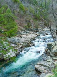
This trail follows Big Laurel Creek through a scenic gorge to its junction with the French Broad river at the old logging ghost town of Runion. This trail is especially nice in early spring when there are many wildflowers blooming along the path and riverbanks, and when the water levels are low and the creek runs clear. The creek is quite large by the time it enters the gorge - almost a river, perhaps explaining the trail's confusing name - and its popularity with boaters and fishermen.
The trail is an old railroad bed which used to carry logs to the Runion sawmill in the 1920's, and as such, is mostly level. However, it's rocky and rooty in spots, so do bring the boots.
A few small streams flow across the trail at various points, and bluffs tower over the river making the valley narrow and enclosed with precipitous slopes on either side. Huge boulders choke the gorge forming raging rapids in places, and a few deep holes invite strong swimmers to take the plunge in warm weather. The trail nears its end at the former logging town of Runion. In its heyday, Runion was home to more than 1,000 people. Brick chimneys and crumbling foundations still remain - one of the few "ghost towns" in North Carolina.
The trail crosses the railroad at the confluence of the Big Laurel and French Broad, and ends on the other side of the tracks at a tranquil riverside flat. Trespassing on railroad property is dangerous, so just follow the trail straight across (after looking and listening for trains - this is an active line!) and do not attempt to cross Big Laurel Creek on the railroad bridge like some have in the past.
Directions
This trail is located in the Hot Springs area. For a list of all the trails in that area, see the Hot Springs trails list page.
All Photos from the Trail


GPS Map
Map Information
Download GPS Data
Click on a route, trail, or point on the map and select the GPS Data tab to download its data.
Data Formats
KML (Google Earth)
KML is the main file type used by Google Earth. If you have Google Earth installed, clicking the KML link should open the trail or point directly in Google Earth for viewing. This is the native file format used by Google Earth, but many other map applications can use and understand KML as well, so if you're not sure which one to download, KML is a good bet.
GPX
The GPX format stands for GPS Exchange - a free, open, XML format for exchanging GPS and map data. GPX is compatible with Google Earth, many other mapping programs, and most GPS devices (such as Garmin). Load the file directly into your GPS to help find your way on your next trip!
GeoJSON
GeoJSON is a newer, lightweight data exchange format which can be used to quickly share map data and may have a smaller size than KML or GPX. Many professional mapping and GIS applications support the GeoJSON format.
About the Map
Copyright
Base Layers
Base layers provided by OpenStreetMap, the US Geological Survey, the US Forest Service, and NC OneMap. Base layer images are subject to the respective copyright policies of their owners. Base layers may not be available at all times due to system maintenance or outages.
WNCOutdoors Base Layer
The WNCOutdoors Base layer is provided by WNCOutdoors.info. It is licensed by Creative Commons Attribution 3.0.
Trail and Marker Overlays
Trail layers and downloadable data are all original works created by WNCOutdoors with guidance from a variety of sources, including ensembles of our own GPS tracks, user contributed GPS tracks, official maps and GIS data from government agencies, and field observations. WNCOutdoors data is made freely available under the Open Database License - you are free to copy and use it for any purpose under the terms of that license (summary).
Tips
- Hover over a trail to see it highlighted. Helps to see start and end points for an individual trail.
- Scroll and zoom the map before printing, and that view will persist into the printed image.
- Click a trail for more details and to download it individually.
Feedback
Ratings
Average Rating: 2.5 (rated 118 times)
Rate It Now:

Dick Nelson said: The people you meet are friendly. The creek is beautiful. The trail is flat. The bluffs are are breathtaking. But the bears, lions, swamp raccoons and don't forget the aligators are all very very dangerous. So, stay away from this lovely hike. Our favorite hiking spot in WNC.
Susie said: This is my second time on this trail and it is beautiful. A nice easy walk through a beautiful gorge full of mountain laurel. Our dog loves it. Lots of places to get in the creek to cool off too! Friendly people and dogs on the trail and a few fishermen. Did not see a single piece of trash. People can be responsible and pet owners as well! We didn’t make it to the end but one of these days we will!