Plunge Basin Trail

At A Glance


0.7 mi one-way
Difficulty Rating: 0.7 ![]()
Steepness: Climbs Moderately ![]()
Tread Condition: Moderately Rough ![]()
Other Map ID: BRP MP 316.4
Hikes That Use This Trail: Linville Falls - Plunge Basin
Description
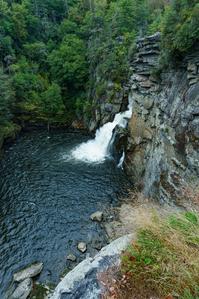
From the visitor center, this trail starts out fairly smooth through a forest of very large hemlocks and white pines to the junction with the Plunge Basin overlook split. The trail to the overlook is downhill and has some obstacles, but is well worth the view. This is a popular spot for photographing the falls. Standing on top of the cliffs above the falls, you have a great view of the pool at the base of the falls and the falls themselves, and the overlooks across the gorge. Past the split, the trail descends, sometimes on steep stairs, below rock cliffs and switches back to end up at the basin itself. This is a magnificent view from the base of the falls. Swimming is not allowed!
Intersecting Trails
This trail is located in the Linville Falls area. For a list of all the trails in that area, see the Linville Falls trails list page.
This trail also crosses into these trailhead areas:
All Photos from the Trail


GPS Map
Map Information
Download GPS Data
Click on a route, trail, or point on the map and select the GPS Data tab to download its data.
Data Formats
KML (Google Earth)
KML is the main file type used by Google Earth. If you have Google Earth installed, clicking the KML link should open the trail or point directly in Google Earth for viewing. This is the native file format used by Google Earth, but many other map applications can use and understand KML as well, so if you're not sure which one to download, KML is a good bet.
GPX
The GPX format stands for GPS Exchange - a free, open, XML format for exchanging GPS and map data. GPX is compatible with Google Earth, many other mapping programs, and most GPS devices (such as Garmin). Load the file directly into your GPS to help find your way on your next trip!
GeoJSON
GeoJSON is a newer, lightweight data exchange format which can be used to quickly share map data and may have a smaller size than KML or GPX. Many professional mapping and GIS applications support the GeoJSON format.
About the Map
Copyright
Base Layers
Base layers provided by OpenStreetMap, the US Geological Survey, the US Forest Service, and NC OneMap. Base layer images are subject to the respective copyright policies of their owners. Base layers may not be available at all times due to system maintenance or outages.
WNCOutdoors Base Layer
The WNCOutdoors Base layer is provided by WNCOutdoors.info. It is licensed by Creative Commons Attribution 3.0.
Trail and Marker Overlays
Trail layers and downloadable data are all original works created by WNCOutdoors with guidance from a variety of sources, including ensembles of our own GPS tracks, user contributed GPS tracks, official maps and GIS data from government agencies, and field observations. WNCOutdoors data is made freely available under the Open Database License - you are free to copy and use it for any purpose under the terms of that license (summary).
Tips
- Hover over a trail to see it highlighted. Helps to see start and end points for an individual trail.
- Scroll and zoom the map before printing, and that view will persist into the printed image.
- Click a trail for more details and to download it individually.
Trail Segments
Trails are often made up of several connecting paths which may have different characteristics, allowed uses, and seasons. This trail is divided into multiple segments as follows:
Plunge Basin
- Allowed Uses: Hiking
- Length: 0.72 mi
Plunge Basin Overlook Spur
- Allowed Uses: Hiking
- Length: 0.15 mi
Total Calculated Length: 0.86 mi
This value is derived from our underlying map data, and it may not match officially published information.
Feedback
Ratings
Average Rating: 4.0 (rated 1 times)
Rate It Now:

[Site Admin] Jordan M. said: Swimming is technically not allowed in any Blue Ridge Parkway waters, including this stretch of the Linville River, but I'm not surprised it wasn't really being enforced. However, you will likely be ticketed if you get caught, so just keep that in mind.
Lee Vandenberg said: Swimming is definitely allowed and if it's not then of the dozens of times I have been there there was nobody to enforce said rule. The basin usually has lots of people swimming in it.