Big Shoals Trail

At A Glance


0.64 mi one-way
Difficulty Rating: 0.64 ![]()
Steepness: Climbs Moderately ![]()
Tread Condition: Some Obstacles ![]()
Description
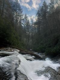
Moderate trail which follows some old road beds and winds onto purpose-built sections of trail. Leads to "Secret Falls". This falls is not so secret anymore.
Big Shoals seems to be one of the original names of the waterfall, but Secret Falls has pretty much stuck as the "real" name now.
This trail is located in the Nantahala National Forest area. For a list of all the trails in that area, see the Nantahala National Forest trails list page.
All Photos from the Trail


GPS Map
Map Information
Download GPS Data
Click on a route, trail, or point on the map and select the GPS Data tab to download its data.
Data Formats
KML (Google Earth)
KML is the main file type used by Google Earth. If you have Google Earth installed, clicking the KML link should open the trail or point directly in Google Earth for viewing. This is the native file format used by Google Earth, but many other map applications can use and understand KML as well, so if you're not sure which one to download, KML is a good bet.
GPX
The GPX format stands for GPS Exchange - a free, open, XML format for exchanging GPS and map data. GPX is compatible with Google Earth, many other mapping programs, and most GPS devices (such as Garmin). Load the file directly into your GPS to help find your way on your next trip!
GeoJSON
GeoJSON is a newer, lightweight data exchange format which can be used to quickly share map data and may have a smaller size than KML or GPX. Many professional mapping and GIS applications support the GeoJSON format.
About the Map
Copyright
Base Layers
Base layers provided by OpenStreetMap, the US Geological Survey, the US Forest Service, and NC OneMap. Base layer images are subject to the respective copyright policies of their owners. Base layers may not be available at all times due to system maintenance or outages.
WNCOutdoors Base Layer
The WNCOutdoors Base layer is provided by WNCOutdoors.info. It is licensed by Creative Commons Attribution 3.0.
Trail and Marker Overlays
Trail layers and downloadable data are all original works created by WNCOutdoors with guidance from a variety of sources, including ensembles of our own GPS tracks, user contributed GPS tracks, official maps and GIS data from government agencies, and field observations. WNCOutdoors data is made freely available under the Open Database License - you are free to copy and use it for any purpose under the terms of that license (summary).
Tips
- Hover over a trail to see it highlighted. Helps to see start and end points for an individual trail.
- Scroll and zoom the map before printing, and that view will persist into the printed image.
- Click a trail for more details and to download it individually.
Feedback
Ratings
Average Rating: (rated 0 times)
Rate It Now:

Roger Lee Wilson said: What gives anyone the right to rename The Big Shoals to secret falls. Their name is The Big Shoals my great great grandfather knew what their name is my grandfather was told the Indians named them The Big Shoals. There was even a factory just above them that was a Pin Mill. The USFS could get someone killed if they fall near The Secret Falls and call 911 I would automatically go out 64 East of Highlands NC the Cashiers Road that’s were The Secret Falls are so you can’t have two in the same 911 area. If you care enough to get the history of The Big Shoals us locals can tell you. Roger Lee Wilson 828-526-5106