Trails in the Nantahala National Forest Trailhead Area

Here is a list of all trails in the Nantahala National Forest Trailhead area.

Each trail has its own printable page with all the information and links, including (where available):

  • directions to the starting point
  • difficulty
  • length
  • elevation change
  • a map
  • photos from along the way, and
  • a detailed description and trail directions.

For general information about the Nantahala National Forest trailhead, see the Nantahala National Forest Trailhead page.

Need to find trails by another method? Go back to Trails.

Alarka Falls Trail

Moderate
  • Unofficial but well-used path leading to the base of Alarka Falls.
  • 0.5mi, Climbs Moderately, Moderately Rough

Big Shoals Trail

Moderate
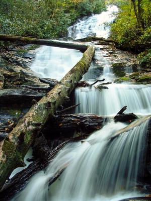
  • Moderate trail which follows some old road beds and winds onto purpose-built sections of trail. Leads to "Secret Falls". This falls is not so secret anymore. Big Shoals seems to be one of the original names of the waterfall, but Secret Falls has...
  • 0.64mi, Climbs Moderately, Some Obstacles

Brooks Cove Trail

  • mi, ,

Cable Cove Nature Trail

  • Cable Cove Nature Trail is located on the Cheoah Ranger District in the Cable Cove Campground. Through out the trail there are numerous tree and shrub species identified by trail signs. The trail length is 1 mile and has an elevation change of 1960...
  • 1.0mi, Climbs Gently,

Cable Gap Trail

  • mi, ,

Hooper Bald Trail

Easy
  • The Hooper Bald Trail is at Milepost 8 on the Cherohala Skyway in western Graham County. The parking area has a nice interpretive display and paved parking. The trail leaves from the parking area and travels east to a large expanse, "the Bald", with...
  • 0.5mi, Climbs Moderately, Few Obstacles

Indian Creek Trail

  • mi, ,

Locust Cove Trail

  • mi, ,

Lookout Rock Trail

  • mi, ,

Maple Springs Trail

Easy
  • The Maple Springs Accessible Trail is a short walk to a wooden lookout point, with a great view to the north, east and south, with the western end of the Great Smoky Mountains National Park in the middle of the viewshed. The Yellow Creek Mountains,...
  • 0.2mi, Climbs Gently, Paved

Nell's Cabin Trail

Moderate
  • An old unmaintained forest road leads along a north slope to the site used for the filming of the movie *Nell*. The cabin has been removed.
  • 1.9mi, Climbs Moderately,

Nolton Ridge Trail

  • mi, ,

Rattler Ford Trail

  • mi, ,

Rufus Morgan Trail

Moderate
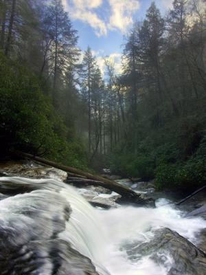
  • The signed, blazed, and easy-to-follow trail is a loop, about a mile long, with no intersections. It leads to 60' Rufus Morgan Falls at its far end - a great destination. There are some steep and narrow spots, but overall it's a moderate trek. One...
  • 1.0mi, Climbs Moderately, Some Obstacles

Santeetlah Bluffs Trail

  • mi, ,

Spirit Ridge Trail

Easy
  • The Spirit Ridge Trail is a paved, ADA accessible trail located near mile marker 10 on the Cherohala Skyway. With easy parking, picnic tables and great views, this trail offers all visitors the opportunity to see the forest at an elevation of 3,700...
  • 0.3mi, Climbs Gently, Paved

Wesser Creek Trail

More Difficult
  • A.T. side trail. This trail is heavily overgrown and in bad condition in places. Passes some cascades and slides on Wesser Creek.
  • 6.2mi, Climbs Moderately, Moderately Rough

Whitewater Falls Walkway Trail

Easy
  • This paved path leads 1/4 mile through a nice forest to the upper overlook for Whitewater Falls. An optional set of 154 wooden steps leads to a lower overlook with a slightly different view. Excellent wheelchair-accessible trail is also great for...
  • 0.3mi, Climbs Gently, Paved